

Sisteron, on the Durance

No reviews yet
Have you flown here? Share your experience with other pilots.
+ Write the first reviewDescription
Sisteron in Provençal Occitan, Sisteroun according to the Mistralian norm and Sisteron according to the classical norm, is a French commune located in the Alpes-de-Haute-Provence department in the Provence-Alpes-Côte d'Azur region.
Capital of the Sogiontii, the ancient Segustero has been a strategic crossing point since Roman times and the building of the bridge over the Durance. A bridge may even have existed here in Gallic times, at the spot where the Heraclean Way reaches the territory of the Vocontii. This bridge, a major one for the whole region, gave the town a radiance lasting a thousand years.
This role led to very early fortifications and a local bishopric from the 6th century. Administratively, the community was granted a consular charter in the 12th century, later turned into a viguerie and then a district after the Revolution, and it was often a border town. Further proof: the bridge-building brothers of the Hospitallers 1,2 asked for and obtained their attachment to the Templars.
With the very recent multiplication of crossings over the Durance, it lost some of its importance, and it never regained its bishopric after the Revolution. Today it is a small industrial and tourist town (a petrochemical plant and industries clustered around the slaughterhouses). Sisteron lies at an altitude of 485 m on the banks of the Durance, 45 km from Forcalquier, 133 km from Marseille, 145 km from Grenoble and 180 km from Nice.
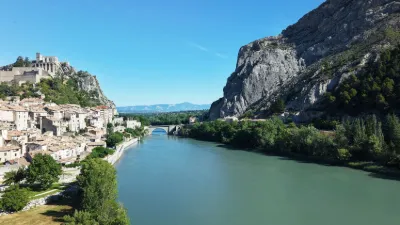
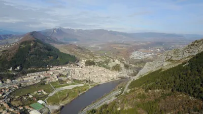
The town occupies a privileged position, close to the confluence of the Buëch and the Durance, where the latter passes through the Baume gorge, on a site easy to fortify. Sisteron is a bridge-site, the only place where a bridge lasted over the Durance from Antiquity to the 19th century.
Nicknamed "the Gateway to Provence", it borders the Dauphiné. It has many monuments, including its citadel, facing the Rocher de la Baume with its almost vertical strata, a 12th-century cathedral, Notre-Dame des Pommiers, five towers, several chapels and the remains of former convents. It is a town that welcomes many tourists drawn by its Mediterranean climate, with an annual average of 300 days of sunshine, its rich and varied heritage, its lake or its airfield.
Map and restricted areas
Open in the main mapNearby aerodromes
Open aerodromes within 25 km of the spot, heliports included, with their distance and direction from the spot. Near an aerodrome, drone flying is prohibited or height-limited: check the UAS zones map.
| Aerodrome | Type | Distance | Elevation | Difference |
|---|---|---|---|---|
| Aérodrome de Sistéron-Vaumeilh | Aerodrome | 11 km N | 540 m | spot 80 m lower |
| Aérodrome de Château-Arnoux - Saint-Auban | Aerodrome | 15 km S | 460 m | same altitude as the spot |
| La Motte du Caire Glider Field | Aerodrome | 16 km NE | 650 m | spot 190 m lower |
Aviation weather (METAR and TAF)
No METAR station within 50 km.
Weather and Kp index
Sunrise and sunset
| Day | Dawn | Sunrise | Golden hour | Sunset | Dusk | Day length |
|---|---|---|---|---|---|---|
| Sat 21 Nov | 07:08 | 07:39 | 07:39–08:24 · 16:20–17:05 | 17:05 | 17:36 | 9 h 25 |
| Sun 22 Nov | 07:09 | 07:41 | 07:41–08:26 · 16:19–17:04 | 17:04 | 17:36 | 9 h 23 |
| Mon 23 Nov | 07:10 | 07:42 | 07:42–08:27 · 16:18–17:03 | 17:03 | 17:35 | 9 h 21 |
| Tue 24 Nov | 07:11 | 07:43 | 07:43–08:28 · 16:17–17:03 | 17:03 | 17:34 | 9 h 19 |
| Wed 25 Nov | 07:12 | 07:44 | 07:44–08:30 · 16:16–17:02 | 17:02 | 17:34 | 9 h 17 |
| Thu 26 Nov | 07:14 | 07:46 | 07:46–08:31 · 16:16–17:01 | 17:01 | 17:33 | 9 h 15 |
| Fri 27 Nov | 07:15 | 07:47 | 07:47–08:33 · 16:15–17:01 | 17:01 | 17:33 | 9 h 14 |



Reviews
Log in to review this spot. Log in · Create a free account
No reviews yet. Share yours!