

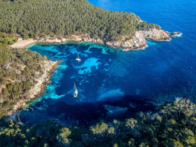
Calanque de Port d'Alon in St Cyr sur mer

No reviews yet
Have you flown here? Share your experience with other pilots.
+ Write the first reviewDescription
Beneath the pines, the little Calanque de Port d'Alon is a true haven of peace in the heart of a magnificent, wooded and unspoiled coastline. Swimming, scuba diving, lounging on the pebble beach or a gourmet stop on the terrace at "Tonton Ju", you will spend an unforgettable day at the Calanque de Port d'Alon between sea, sky and sun.
A CALANQUE BETWEEN SEA AND NATURE Shaded by a pine grove and dotted with clusters of holm oaks, agaves and prickly pear trees, the Calanque de Port d'Alon has preserved all the magic of the landscapes of southern Provence. Here, the song of the cicadas blends with the murmur of the waves, and the shade of the Aleppo pines and the gentle sea breeze make the warm sunlight even more pleasant.
The pebble beach nestled at the back of the Calanque de Port d'Alon is a great place to lay your towel for the day. You can also retreat to a more secluded spot under the trees. Large flat areas give children other playgrounds to explore.
On the sea side, all the beauty of the Mediterranean awaits you. Swimming is the favorite activity of many tourists. You can also try snorkeling or scuba diving. Guided snorkeling hikes are also organized in season to discover the marine environment.
Map and restricted areas
Open in the main mapNearby aerodromes
Open aerodromes within 25 km of the spot, heliports included, with their distance and direction from the spot. Near an aerodrome, drone flying is prohibited or height-limited: check the UAS zones map.
| Aerodrome | Type | Distance | Elevation | Difference |
|---|---|---|---|---|
| Base Hydro-ULM de La Ciotat | Seaplane base | 6.3 km NW | 0 m | spot 12 m higher |
| Le Castellet Airport | Airport | 13 km NE | 424 m | spot 412 m lower |
| Milhaud Heliport | Heliport | 16 km E | 1 m | spot 11 m higher |
| Zi Les Paluds Heliport | Heliport | 18 km NW | 116 m | spot 103 m lower |
| Toulon Sainte Anne Heliport | Heliport | 18 km E | 69 m | spot 57 m lower |
Aviation weather (METAR and TAF)
LFTH – Toulon-Hyères Airport VFR
METAR
METAR LFTH 210630Z AUTO 27005KT 250V310 CAVOK 14/05 Q1018 NOSIG
- Wind
- 270°, 9 km/h
- Visibility
- 10 km or more
- Clouds
- –
- Temperature
- 14 °C, dew point 5 °C
- QNH
- 1018 hPa
- Flight category
- VFR: ceiling > 3,000 ft and visibility > 5 mi
TAF
TAF LFTH 210200Z 2103/2203 30007KT CAVOK BECMG 2119/2122 VRB05KT BKN020 TEMPO 2122/2203 18010KT -RA BKN014 BKN025
| Period (local time) | Change | Wind | Visibility | Weather | Clouds |
|---|---|---|---|---|---|
| 21/11 04:00 → 21/11 20:00 | Initial conditions | 300°, 13 km/h | 10 km or more | No significant weather | No significant cloud |
| 21/11 20:00 → 22/11 04:00 | Becoming | Variable, 9 km/h | 10 km or more | No significant weather | Broken (5-7/8) at 2,000 ft (610 m) |
| 21/11 23:00 → 22/11 04:00 | Temporarily | 180°, 19 km/h | Rain light | Broken (5-7/8) at 1,400 ft (430 m) ; Broken (5-7/8) at 2,500 ft (760 m) |
Weather and Kp index
| Day | Weather | Temp. min. / max. | Wind | Rain | Max Kp |
|---|---|---|---|---|---|
| Sat 21 Nov | Fair | 11° / 16° | 23 km/h NW | 1.6 mm | 2 |
| Sun 22 Nov | Clear sky | 12° / 16° | 57 km/h NW | 10 mm | 2 |
| Mon 23 Nov | Fair | 10° / 14° | 55 km/h NW | – | 4 |
| Tue 24 Nov | Cloudy | 8° / 14° | 20 km/h E | 0.8 mm | 2 |
| Wed 25 Nov | Rain | 10° / 11° | 34 km/h E | 30 mm | – |
| Thu 26 Nov | Cloudy | 6° / 13° | 17 km/h N | 6.1 mm | – |
| Fri 27 Nov | Fair | 6° / 13° | 13 km/h NW | – | – |
Hour by hour: Saturday 21 November
| Time | Weather | Temp. | Wind | Rain | Clouds | Kp |
|---|---|---|---|---|---|---|
| 08:00 | Cloudy | 11° | 21 km/h NW | – | 96 % | 2 |
| 09:00 | Cloudy | 12° | 23 km/h NW | – | 99 % | 2 |
| 10:00 | Cloudy | 14° | 23 km/h NW | – | 88 % | 2 |
| 11:00 | Partly cloudy | 15° | 22 km/h NW | – | 81 % | 2 |
| 12:00 | Partly cloudy | 15° | 23 km/h W | – | 54 % | 2 |
| 13:00 | Fair | 16° | 22 km/h W | – | 33 % | 1 |
| 14:00 | Partly cloudy | 16° | 18 km/h W | – | 45 % | 1 |
| 15:00 | Partly cloudy | 16° | 17 km/h W | – | 39 % | 1 |
| 16:00 | Partly cloudy | 15° | 13 km/h W | – | 49 % | 2 |
| 17:00 | Partly cloudy | 13° | 10 km/h W | – | 80 % | 2 |
| 18:00 | Partly cloudy | 12° | 6 km/h NW | – | 84 % | 2 |
| 19:00 | Partly cloudy | 12° | 6 km/h NE | – | 85 % | 2 |
| 20:00 | Cloudy | 12° | 12 km/h E | – | 97 % | 2 |
| 21:00 | Cloudy | 13° | 17 km/h E | – | 100 % | 2 |
| 22:00 | Light rain | 13° | 19 km/h E | 0.3 mm | 100 % | 2 |
Hour by hour: Sunday 22 November
| Time | Weather | Temp. | Wind | Rain | Clouds | Kp |
|---|---|---|---|---|---|---|
| 06:00 | Heavy rain | 16° | 26 km/h S | 1.8 mm | 100 % | 2 |
| 07:00 | Rain | 15° | 27 km/h S | 0.8 mm | 100 % | 2 |
| 08:00 | Heavy rain | 16° | 32 km/h SW | 2.9 mm | 97 % | 2 |
| 09:00 | Rain | 16° | 36 km/h W | 0.8 mm | 96 % | 2 |
| 10:00 | Light rain | 15° | 51 km/h W | 0.2 mm | 97 % | 2 |
| 11:00 | Partly cloudy | 15° | 57 km/h NW | – | 71 % | 2 |
| 12:00 | Partly cloudy | 15° | 50 km/h NW | – | 84 % | 2 |
| 13:00 | Clear sky | 15° | 51 km/h NW | – | 6 % | 2 |
| 14:00 | Fair | 16° | 51 km/h NW | – | 17 % | 2 |
| 15:00 | Clear sky | 15° | 53 km/h W | – | 6 % | 2 |
| 16:00 | Clear sky | 15° | 51 km/h W | – | 6 % | 2 |
| 17:00 | Clear sky | 14° | 53 km/h W | – | 10 % | 2 |
| 18:00 | Clear sky | 13° | 53 km/h W | – | 7 % | 2 |
| 19:00 | Clear sky | 13° | 53 km/h W | – | 11 % | 2 |
| 20:00 | Fair | 12° | 53 km/h W | – | 20 % | 2 |
| 21:00 | Clear sky | 12° | 55 km/h NW | – | 12 % | 2 |
| 22:00 | Clear sky | 12° | 55 km/h NW | – | 12 % | 2 |
Sunrise and sunset
| Day | Dawn | Sunrise | Golden hour | Sunset | Dusk | Day length |
|---|---|---|---|---|---|---|
| Sat 21 Nov | 07:06 | 07:37 | 07:37–08:21 · 16:25–17:09 | 17:09 | 17:40 | 9 h 31 |
| Sun 22 Nov | 07:08 | 07:39 | 07:39–08:23 · 16:24–17:08 | 17:08 | 17:39 | 9 h 29 |
| Mon 23 Nov | 07:09 | 07:40 | 07:40–08:24 · 16:23–17:07 | 17:07 | 17:38 | 9 h 27 |
| Tue 24 Nov | 07:10 | 07:41 | 07:41–08:25 · 16:22–17:07 | 17:07 | 17:38 | 9 h 25 |
| Wed 25 Nov | 07:11 | 07:42 | 07:42–08:27 · 16:22–17:06 | 17:06 | 17:37 | 9 h 23 |
| Thu 26 Nov | 07:12 | 07:43 | 07:43–08:28 · 16:21–17:05 | 17:05 | 17:37 | 9 h 22 |
| Fri 27 Nov | 07:13 | 07:45 | 07:45–08:29 · 16:20–17:05 | 17:05 | 17:36 | 9 h 20 |





Reviews
Log in to review this spot. Log in · Create a free account
No reviews yet. Share yours!