Skip to content
Unusual

Nugget point - Catlins
New Zealand

The video is only loaded from YouTube (youtube-nocookie.com) when you start it.

1 pilot review

“Hélas, depuis fin 2018. Le survol du lieu est désormais interdit aux drones. C'est devenu…” — ThoutmesIV, 7 years ago

Read the reviews + Write my review

Description

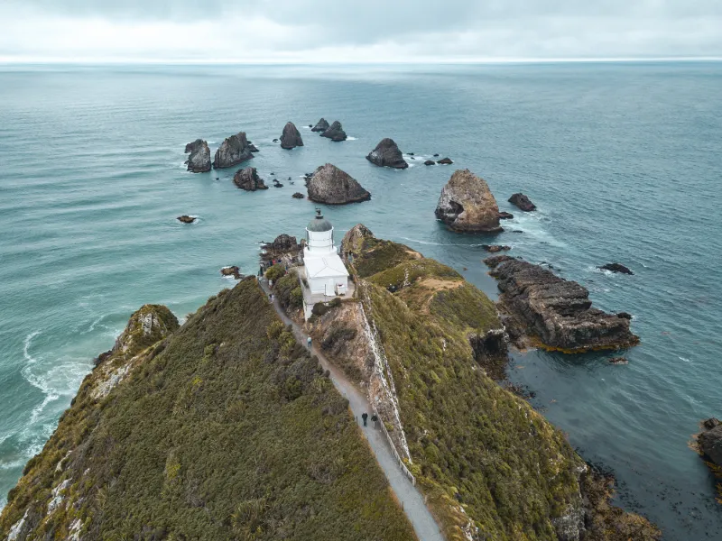
Nugget point, a particularly well known spot on the south island with these rocks out of the water in the shape of a nugget nugget. easy access (15 minutes) from the car park Video from : 1:18

Plan the light

Weather and Kp index

Loading forecast…

Sunrise and sunset

Local times at the spot (UTC+13:00). The golden hour, the warm, low light sought after for photos and videos, runs from sunrise until the sun reaches 6° above the horizon, and in the evening from 6° until sunset.

Day Dawn Sunrise Golden hour Sunset Dusk Day length
Sun 22 Nov05:14 05:50 05:50–06:35 · 20:18–21:03 21:03 21:3915 h 12
Mon 23 Nov05:13 05:50 05:50–06:34 · 20:20–21:04 21:04 21:4115 h 14
Tue 24 Nov05:12 05:49 05:49–06:34 · 20:21–21:06 21:06 21:4215 h 16
Wed 25 Nov05:11 05:48 05:48–06:33 · 20:22–21:07 21:07 21:4415 h 19
Thu 26 Nov05:10 05:47 05:47–06:32 · 20:23–21:08 21:08 21:4515 h 21
Fri 27 Nov05:10 05:47 05:47–06:32 · 20:24–21:10 21:10 21:4715 h 23
Sat 28 Nov05:09 05:46 05:46–06:31 · 20:26–21:11 21:11 21:4815 h 25

Nearby on Wikipedia

  • Phare de Nugget Point · 0.4 km away

    Le phare de Nugget Point est un phare situé sur Nugget Point, dans la région d' Otago (île du Sud), en Nouvelle-Zélande. (...)

  • Nugget Point · 0.5 km away

    Nugget Point est un cap de la côte d'Otago, en Nouvelle-Zélande. Situé à l'extrémité nord de la côte des Catlins, le long de la route de , ce promontoire escarpé a un phare à son extrémité (le phare de Nugget Point) et est entouré d'îlots rocheux appelés les (« pépites ») (...)

  • Puerua (rivière) · 8.0 km away

    La rivière Puerua est une rivière de la région de South Otago, dans l’Ile du Sud de la Nouvelle-Zélande. C’est un affluent de la rivière Clutha. La Puerua prend naissance à l’est de “Brown Dome” et s’écoule vers l’est pour rejoindre la rivière Clutha près de « Port Molyneux ». (...)

  • Catlins (fleuve) · 8.8 km away

    Le fleuve Catlins est un cours d’eau du district de Clutha, dans la région d’Otago, dans l’Île du Sud en Nouvelle-Zélande. (...)

  • Owaka (rivière) · 9.5 km away

    La rivière Owaka (en) est un cours d’eau du sud de l’Île du Sud de la Nouvelle-Zélande. (...)

Articles found by GeoNames from the spot's position.

Reviews

Log in to review this spot. Log in · Create a free account

  1. ThoutmesIV

    Hélas, depuis fin 2018. Le survol du lieu est désormais interdit aux drones. C'est devenu hélas le cas, également, pour certains parcs nationaux à forte fréquentation.

Connection to the site lost. Trying again…

The site is not responding. Trying again in seconds.

The site is no longer responding.

The site has been updated. Reloading the page…

This page has expired.

Resuming failed. Please reload the page.

The site is no longer responding.