

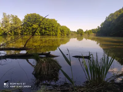
Lake Moras
No reviews yet
Have you flown here? Share your experience with other pilots.
+ Write the first reviewDescription
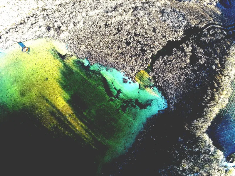
The light gives colours to the bottom of the lake
Map and restricted areas
Open in the main mapNearby aerodromes
Open aerodromes within 25 km of the spot, heliports included, with their distance and direction from the spot. Near an aerodrome, drone flying is prohibited or height-limited: check the UAS zones map.
| Aerodrome | Type | Distance | Elevation | Difference |
|---|---|---|---|---|
| Morestel Airport | Aerodrome | 14 km E | 245 m | spot 57 m higher |
| Lyon Saint-Exupéry Airport | Major airport | 15 km W | 250 m | spot 52 m higher |
| La Tour Du Pin Airfield | Aerodrome | 16 km SE | 320 m | spot 18 m lower |
| Aérodrome de Pérouges - Meximieux | Aerodrome | 22 km N | 214 m | spot 88 m higher |
| Hôtel Le Château Heliport | Heliport | 23 km SE | 387 m | spot 85 m lower |
Aviation weather (METAR and TAF)
LFLL – Lyon Saint-Exupéry Airport VFR
METAR
METAR LFLL 222300Z 27008KT 9999 OVC046 11/07 Q1017 NOSIG
- Wind
- 270°, 15 km/h
- Visibility
- 10 km or more
- Clouds
- Overcast (8/8) at 4,600 ft (1400 m)
- Temperature
- 11 °C, dew point 7 °C
- QNH
- 1017 hPa
- Flight category
- VFR: ceiling > 3,000 ft and visibility > 5 mi
TAF
TAF LFLL 222300Z 2300/2406 28010KT 9999 BKN035 OVC070 BECMG 2300/2303 22005KT SCT035 FM230800 23007KT 9999 OVC035 TEMPO 2309/2315 4500 -RA BKN020 PROB30 TEMPO 2313/2315 BKN014 FM231500 32010KT 9999 OVC020 TEMPO 2315/2320 BKN012 BECMG 2320/2323 VRB02KT 3500 BR OVC008 PROB40 2400/2404 2000 OVC004 PROB40 2404/2406 0800 FG OVC001
| Period (local time) | Change | Wind | Visibility | Weather | Clouds |
|---|---|---|---|---|---|
| 23/11 01:00 → 24/11 07:00 | Initial conditions | 280°, 19 km/h | 10 km or more | Broken (5-7/8) at 3,500 ft (1070 m) ; Overcast (8/8) at 7,000 ft (2130 m) | |
| 23/11 01:00 → 23/11 09:00 | Becoming | 220°, 9 km/h | 10 km or more | Scattered (3-4/8) at 3,500 ft (1070 m) | |
| 23/11 09:00 → 23/11 16:00 | From | 230°, 13 km/h | 10 km or more | Overcast (8/8) at 3,500 ft (1070 m) | |
| 23/11 10:00 → 23/11 16:00 | Temporarily | 4.5 km | Rain light | Broken (5-7/8) at 2,000 ft (610 m) | |
| 23/11 14:00 → 23/11 16:00 | Temporarily, probability 30% | Broken (5-7/8) at 1,400 ft (430 m) | |||
| 23/11 16:00 → 23/11 21:00 | Temporarily | Broken (5-7/8) at 1,200 ft (370 m) | |||
| 23/11 16:00 → 23/11 21:00 | From | 320°, 19 km/h | 10 km or more | Overcast (8/8) at 2,000 ft (610 m) | |
| 23/11 21:00 → 24/11 07:00 | Becoming | Variable, 4 km/h | 3.5 km | Mist | Overcast (8/8) at 800 ft (240 m) |
| 24/11 01:00 → 24/11 05:00 | probability 40% | 2.0 km | Overcast (8/8) at 400 ft (120 m) | ||
| 24/11 05:00 → 24/11 07:00 | probability 40% | 800 m | Fog | Overcast (8/8) at 100 ft (30 m) |
Weather and Kp index
Sunrise and sunset
| Day | Dawn | Sunrise | Golden hour | Sunset | Dusk | Day length |
|---|---|---|---|---|---|---|
| Mon 23 Nov | 07:16 | 07:49 | 07:49–08:36 · 16:14–17:01 | 17:01 | 17:34 | 9 h 12 |
| Tue 24 Nov | 07:18 | 07:51 | 07:51–08:38 · 16:14–17:01 | 17:01 | 17:34 | 9 h 10 |
| Wed 25 Nov | 07:19 | 07:52 | 07:52–08:39 · 16:13–17:00 | 17:00 | 17:33 | 9 h 08 |
| Thu 26 Nov | 07:20 | 07:53 | 07:53–08:41 · 16:12–16:59 | 16:59 | 17:32 | 9 h 06 |
| Fri 27 Nov | 07:21 | 07:54 | 07:54–08:42 · 16:11–16:59 | 16:59 | 17:32 | 9 h 04 |
| Sat 28 Nov | 07:22 | 07:56 | 07:56–08:43 · 16:10–16:58 | 16:58 | 17:31 | 9 h 02 |
| Sun 29 Nov | 07:23 | 07:57 | 07:57–08:45 · 16:10–16:58 | 16:58 | 17:31 | 9 h 00 |


Reviews
Log in to review this spot. Log in · Create a free account
No reviews yet. Share yours!