

Mountain
Angleur
Description
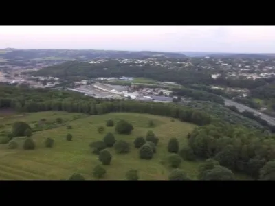
Spot located in the moors of Streupas. Unobstructed spot with an unobstructed view of Angleur, Chenee, Embourg. Access via the back of the angleur football field located rue de la belle jardinière, a few steps from the recyparc.
Map and restricted areas
Open in the main mapAviation weather (METAR and TAF)
EBLG – Liège Airport VFR
METAR
METAR EBLG 222050Z 07002KT CAVOK 00/M01 Q1016 NOSIG
- Wind
- 070°, 4 km/h
- Visibility
- 10 km or more
- Clouds
- –
- Temperature
- 0 °C, dew point -1 °C
- QNH
- 1016 hPa
- Flight category
- VFR: ceiling > 3,000 ft and visibility > 5 mi
TAF
TAF EBLG 221700Z 2218/2324 05008KT CAVOK TEMPO 2218/2311 3000 BR BKN004 PROB30 TEMPO 2219/2224 0400 FG BKN001 PROB40 TEMPO 2300/2310 0400 FZFG BKN001
| Period (local time) | Change | Wind | Visibility | Weather | Clouds |
|---|---|---|---|---|---|
| 22/11 19:00 → 24/11 01:00 | Initial conditions | 050°, 15 km/h | 10 km or more | No significant weather | No significant cloud |
| 22/11 19:00 → 23/11 12:00 | Temporarily | 3.0 km | Mist | Broken (5-7/8) at 400 ft (120 m) | |
| 22/11 20:00 → 23/11 01:00 | Temporarily, probability 30% | 400 m | Fog | Broken (5-7/8) at 100 ft (30 m) | |
| 23/11 01:00 → 23/11 11:00 | Temporarily, probability 40% | 400 m | Freezing fog | Broken (5-7/8) at 100 ft (30 m) |
Weather and Kp index
| Day | Weather | Temp. min. / max. | Wind | Rain | Max Kp |
|---|---|---|---|---|---|
| Sun 22 Nov | Partly cloudy | -0° / -0° | 6 km/h NE | – | 1 |
| Mon 23 Nov | Clear sky | -3° / 3° | 10 km/h NE | – | 4 |
| Tue 24 Nov | Clear sky | -3° / 4° | 20 km/h SE | – | 2 |
| Wed 25 Nov | Cloudy | -1° / 3° | 19 km/h SE | 0.5 mm | 2 |
| Thu 26 Nov | Partly cloudy | -4° / 0° | 15 km/h NE | – | – |
| Fri 27 Nov | Partly cloudy | -3° / 2° | 11 km/h NE | – | – |
| Sat 28 Nov | Partly cloudy | -4° / 3° | 8 km/h E | – | – |
Hour by hour: Sunday 22 November
| Time | Weather | Temp. | Wind | Rain | Clouds | Kp |
|---|---|---|---|---|---|---|
| 22:00 | Partly cloudy | -0° | 6 km/h NE | – | 84 % | 1 |
Hour by hour: Monday 23 November
| Time | Weather | Temp. | Wind | Rain | Clouds | Kp |
|---|---|---|---|---|---|---|
| 06:00 | Cloudy | 0° | 10 km/h NE | – | 98 % | 2 |
| 07:00 | Cloudy | 0° | 10 km/h NE | – | 99 % | 2 |
| 08:00 | Cloudy | -0° | 9 km/h NE | – | 94 % | 2 |
| 09:00 | Partly cloudy | -0° | 9 km/h NE | – | 54 % | 2 |
| 10:00 | Fair | 0° | 8 km/h NE | – | 14 % | 2 |
| 11:00 | Clear sky | 1° | 8 km/h NE | – | 2 % | 2 |
| 12:00 | Clear sky | 2° | 7 km/h NE | – | 1 % | 2 |
| 13:00 | Clear sky | 3° | 8 km/h NE | – | 0 % | 4 |
| 14:00 | Clear sky | 3° | 9 km/h NE | – | 0 % | 4 |
| 15:00 | Clear sky | 3° | 9 km/h NE | – | 0 % | 4 |
| 16:00 | Clear sky | 2° | 8 km/h NE | – | 0 % | 4 |
| 17:00 | Clear sky | 0° | 8 km/h NE | – | 0 % | 4 |
| 18:00 | Clear sky | -1° | 8 km/h NE | – | 0 % | 4 |
| 19:00 | Clear sky | -2° | 7 km/h E | – | 0 % | 3 |
| 20:00 | Clear sky | -2° | 8 km/h SE | – | 0 % | 3 |
| 21:00 | Clear sky | -3° | 9 km/h SE | – | 0 % | 3 |
| 22:00 | Clear sky | -3° | 10 km/h SE | – | 0 % | 2 |
Sunrise and sunset
| Day | Dawn | Sunrise | Golden hour | Sunset | Dusk | Day length |
|---|---|---|---|---|---|---|
| Sun 22 Nov | 07:27 | 08:04 | 08:04–08:58 · 15:50–16:44 | 16:44 | 17:21 | 8 h 39 |
| Mon 23 Nov | 07:28 | 08:05 | 08:05–09:00 · 15:48–16:43 | 16:43 | 17:20 | 8 h 37 |
| Tue 24 Nov | 07:30 | 08:07 | 08:07–09:02 · 15:47–16:42 | 16:42 | 17:19 | 8 h 34 |
| Wed 25 Nov | 07:31 | 08:08 | 08:08–09:03 · 15:46–16:41 | 16:41 | 17:18 | 8 h 32 |
| Thu 26 Nov | 07:32 | 08:10 | 08:10–09:05 · 15:45–16:40 | 16:40 | 17:17 | 8 h 30 |
| Fri 27 Nov | 07:34 | 08:11 | 08:11–09:07 · 15:44–16:39 | 16:39 | 17:17 | 8 h 27 |
| Sat 28 Nov | 07:35 | 08:13 | 08:13–09:09 · 15:43–16:38 | 16:38 | 17:16 | 8 h 25 |




Reviews
Log in to review this spot. Log in · Create a free account
RobinF-V
Très bon spot!