Home
›
Hungary
›
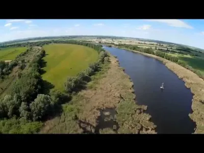
Lake Riha from the air Water
Lake Riha from the air
Hungary
We have no zone data for this country: ask the local authority before flying.Official zones map (Hungary)
The video is only loaded from YouTube (youtube-nocookie.com) when you start it.
Description The footage was recorded in cooperation with the Duna-Dráva National Park, during a survey of the area's special birdlife.
Automatic translation.
Spot details
Maximum height
120 m max
Access
On foot > 1,000 m
Elevation
84 m
Near
Mohács · 6.6 km E
GPS coordinates
46.00948, 18.76752
Added on
12 January 2021
Views
112 The information shown here is published for guidance only: height and access are reported by pilots. Drone-Spot.tech accepts no liability in this respect. Before every flight, check the regulations and the restricted areas on the map: you remain responsible for your flight.
Report a mistake or a problem with this spot
Map and zones
METAR and TAF
Weather and sun Around the spot
Aviation weather (METAR and TAF) LHPP – Pécs-Pogány Airport
· 41 km W
VFR
METAR
Observed 21/11 18:15 · 34 min ago
METAR LHPP 211715Z AUTO 30004KT CAVOK 06/M01 Q1019
Wind
300°, 7 km/h Visibility
10 km or more Clouds
– Temperature
6 °C, dew point -1 °C QNH
1019 hPa Flight category
VFR: ceiling > 3,000 ft and visibility > 5 mi TAF Issued 21/11 15:15 · valid from 21/11 16:00 to 22/11 01:00
TAF LHPP 211415Z 2115/2124 31012G22KT CAVOK TEMPO 2115/2116 SCT025 BECMG 2115/2118 VRB03KT
Period (local time)
Change
Wind
Visibility
Weather
Clouds 21/11 16:00 → 22/11 01:00
Initial conditions
310°, 22 km/h, gusts 41 km/h
10 km or more
No significant weather
No significant cloud 21/11 16:00 → 21/11 17:00
Temporarily
Scattered (3-4/8) at 2,500 ft (760 m) 21/11 16:00 → 22/11 01:00
Becoming
Variable, 6 km/h
10 km or more
No significant weather
No significant cloud
Empty cell: no change forecast for that element.
METAR and TAF from NOAA (Aviation Weather Center), for guidance only: they do not replace flight planning with official sources (SIA, Météo-France). Nearest station that issues a METAR, not necessarily the nearest aerodrome.
Weather and Kp index Loading forecast…
Sunrise and sunset
Local times at the spot (UTC+01:00). The golden hour, the warm, low light sought after for photos and videos, runs from sunrise until the sun reaches 6° above the horizon, and in the evening from 6° until sunset.
Day
Dawn
Sunrise
Golden hour
Sunset
Dusk
Day length Sat 21 Nov 06:21
06:54
06:54–07:41 · 15:21–16:08
16:08
16:41 9 h 14 Sun 22 Nov 06:22
06:55
06:55–07:42 · 15:20–16:07
16:07
16:40 9 h 12 Mon 23 Nov 06:23
06:56
06:56–07:44 · 15:19–16:06
16:06
16:39 9 h 10 Tue 24 Nov 06:24
06:58
06:58–07:45 · 15:18–16:06
16:06
16:39 9 h 08 Wed 25 Nov 06:26
06:59
06:59–07:47 · 15:17–16:05
16:05
16:38 9 h 06 Thu 26 Nov 06:27
07:00
07:00–07:48 · 15:16–16:04
16:04
16:38 9 h 04 Fri 27 Nov 06:28
07:01
07:01–07:49 · 15:16–16:04
16:04
16:37 9 h 02
Nearby on Wikipedia
Homorúd · 3.1 km away Homorúd est un village et une commune du comitat de Baranya en Hongrie. (...)
Bár · 6.1 km away Bár est un village et une commune du comitat de Baranya en Hongrie. (...)
Micro-région de Mohács · 6.6 km away La micro-région de Mohács est une micro-région statistique hongroise rassemblant plusieurs localités autour de Mohács. (...)
Mohács · 6.9 km away Mohács (; ; ou ;) est une localité hongroise ayant le rang de ville dans le comitat de Baranya. Chef-lieu de la micro-région de Mohács, elle se situe sur la rive ouest du Danube. Mohács est surtout célèbre pour la Bataille de Mohács, survenue le : l'armée ottomane de Soliman le Magnifique y a écrasé (...)
Dunaszekcső · 8.1 km away Dunaszekcső est un village et une commune du comitat de Baranya en Hongrie. (...)
Articles found by GeoNames from the spot's position.


Reviews
Log in to review this spot. Log in · Create a free account
No reviews yet. Share yours!