

Heritage
Františkova huta Podbiel
No reviews yet
Have you flown here? Share your experience with other pilots.
+ Write the first reviewDescription
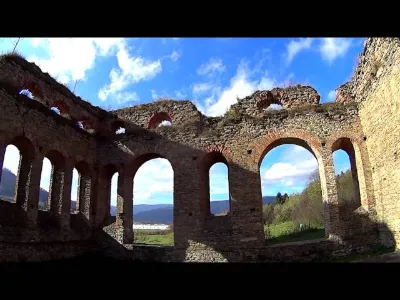
Františkova huta (locally just Hámor) is a technical monument, the ruin of the factory hall of an ironworks (iron foundry) from 1836. It is located in Orava, in the cadastral area of the municipality of Nižná, in the valley of the Studený potok stream, 2 km along the road to Zuberec. The building is owned by the municipality of Podbiel, which received it through a donation agreement signed on 9.10.2009 from the civic association Strom života. The classicist façade, the perimeter walls, the blast furnace, the supply and waste channels, the hammer mill, the blower chamber and the iron ore heap (behind the building) have been preserved.
Map and restricted areas
Open in the main mapWeather and Kp index
Sunrise and sunset
| Day | Dawn | Sunrise | Golden hour | Sunset | Dusk | Day length |
|---|---|---|---|---|---|---|
| Sat 21 Nov | 06:26 | 07:02 | 07:02–07:53 · 15:02–15:54 | 15:54 | 16:29 | 8 h 52 |
| Sun 22 Nov | 06:28 | 07:03 | 07:03–07:55 · 15:01–15:53 | 15:53 | 16:29 | 8 h 49 |
| Mon 23 Nov | 06:29 | 07:05 | 07:05–07:57 · 15:00–15:52 | 15:52 | 16:28 | 8 h 47 |
| Tue 24 Nov | 06:30 | 07:06 | 07:06–07:58 · 14:59–15:51 | 15:51 | 16:27 | 8 h 45 |
| Wed 25 Nov | 06:32 | 07:07 | 07:07–08:00 · 14:58–15:50 | 15:50 | 16:26 | 8 h 42 |
| Thu 26 Nov | 06:33 | 07:09 | 07:09–08:02 · 14:57–15:50 | 15:50 | 16:26 | 8 h 40 |
| Fri 27 Nov | 06:34 | 07:10 | 07:10–08:03 · 14:56–15:49 | 15:49 | 16:25 | 8 h 38 |
Reviews
Log in to review this spot. Log in · Create a free account
No reviews yet. Share yours!