Home
›
Hungary
›
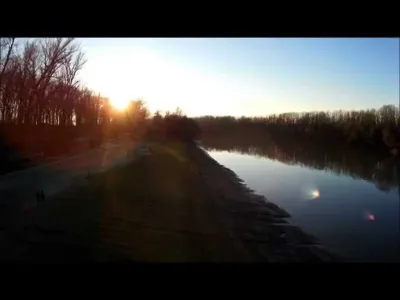
Tiszakécske public beach Water
Tiszakécske public beach
Hungary
We have no zone data for this country: ask the local authority before flying.Official zones map (Hungary)
The video is only loaded from YouTube (youtube-nocookie.com) when you start it.
Description MUSIC BY : The Scientist - Coldplay Cover by Luciana Zogbi
Automatic translation.
Spot details
Maximum height
120 m max
Access
On foot < 1,000 m
Elevation
78 m
Near
Tiszakécske · 1.7 km NE
GPS coordinates
46.94183, 20.12084
Added on
12 January 2021
Views
145 The information shown here is published for guidance only: height and access are reported by pilots. Drone-Spot.tech accepts no liability in this respect. Before every flight, check the regulations and the restricted areas on the map: you remain responsible for your flight.
Report a mistake or a problem with this spot
Map and zones
METAR and TAF
Weather and sun Around the spot
Aviation weather (METAR and TAF) LHSN – Szolnok Air Base
· 22 km NE
VFR
METAR
Observed 21/11 18:15 · 34 min ago
METAR LHSN 211715Z 29008KT 260V320 CAVOK 06/01 Q1017 NOSIG RMK BLU
Wind
290°, 15 km/h Visibility
10 km or more Clouds
– Temperature
6 °C, dew point 1 °C QNH
1017 hPa Flight category
VFR: ceiling > 3,000 ft and visibility > 5 mi TAF Issued 21/11 18:15 · valid from 21/11 19:00 to 22/11 04:00
TAF LHSN 211715Z 2118/2203 28008KT CAVOK BECMG 2120/2122 25006KT
Period (local time)
Change
Wind
Visibility
Weather
Clouds 21/11 19:00 → 21/11 21:00
Initial conditions
280°, 15 km/h
10 km or more
No significant weather
No significant cloud 21/11 21:00 → 22/11 04:00
Becoming
250°, 11 km/h
10 km or more
No significant weather
No significant cloud
Empty cell: no change forecast for that element.
METAR and TAF from NOAA (Aviation Weather Center), for guidance only: they do not replace flight planning with official sources (SIA, Météo-France). Nearest station that issues a METAR, not necessarily the nearest aerodrome.
Weather and Kp index Loading forecast…
Sunrise and sunset
Local times at the spot (UTC+01:00). The golden hour, the warm, low light sought after for photos and videos, runs from sunrise until the sun reaches 6° above the horizon, and in the evening from 6° until sunset.
Day
Dawn
Sunrise
Golden hour
Sunset
Dusk
Day length Sat 21 Nov 06:18
06:51
06:51–07:39 · 15:11–16:00
16:00
16:33 9 h 08 Sun 22 Nov 06:19
06:52
06:52–07:41 · 15:10–15:59
15:59
16:32 9 h 06 Mon 23 Nov 06:20
06:54
06:54–07:42 · 15:09–15:58
15:58
16:32 9 h 04 Tue 24 Nov 06:21
06:55
06:55–07:44 · 15:08–15:57
15:57
16:31 9 h 01 Wed 25 Nov 06:23
06:57
06:57–07:45 · 15:07–15:56
15:56
16:30 8 h 59 Thu 26 Nov 06:24
06:58
06:58–07:47 · 15:07–15:56
15:56
16:30 8 h 57 Fri 27 Nov 06:25
06:59
06:59–07:48 · 15:06–15:55
15:55
16:29 8 h 55
Nearby on Wikipedia
Nagyrév · 2.2 km away Nagyrév est un village et une commune du comitat de Jász-Nagykun-Szolnok en Hongrie. (...)
Tiszakécske · 2.3 km away Tiszakécske est une ville du comitat de Bács-Kiskun, en Hongrie, formée par la réunion d'Ókécske (« ancien Kécske ») et d'Újkécske (« nouveau Kécske ») en 1950. (...)
Tiszainoka · 4.8 km away Tiszainoka est un village et une commune du comitat de Jász-Nagykun-Szolnok en Hongrie. (...)
Cibakháza · 6.2 km away Cibakháza est un village et une commune du comitat de Jász-Nagykun-Szolnok en Hongrie. (...)
Tiszakürt · 6.5 km away Tiszakürt est un village et une commune du comitat de Jász-Nagykun-Szolnok en Hongrie. (...)
Articles found by GeoNames from the spot's position.


Reviews
Log in to review this spot. Log in · Create a free account
No reviews yet. Share yours!