

Meyreuil, le Montaiguet

No reviews yet
Have you flown here? Share your experience with other pilots.
+ Write the first reviewDescription
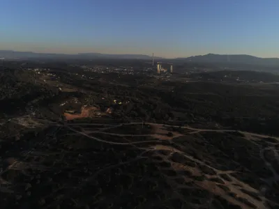
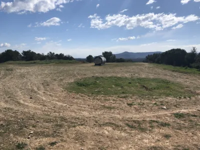
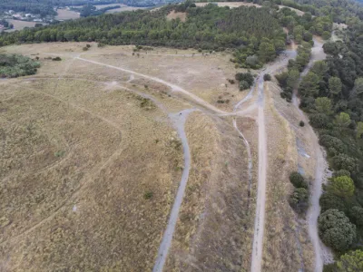
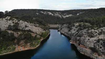
The Montaiguet massif, nicknamed "the hill of the Aixois"1, is a wooded massif in the Bouches-du-Rhône located between Aix-en-Provence, Gardanne and Meyreuil. 6 kilometers long and 3 to 5 kilometers wide, its altitude ranges from 150 to 346 m. Its surface area, about 20 km2, is made up of limestone plateaus bordered by cliffs, pine and oak woods, and vineyards or other plantations2. The massif suffered a major fire in August 20053. In October 2010, 1,500 m2 were burned. Since the fires, the vegetation has gradually turned into garrigue.
The Arc forms its northern boundary south of Aix-en-Provence. It lies between the communes of Meyreuil, Gardanne, and Aix-en-Provence.
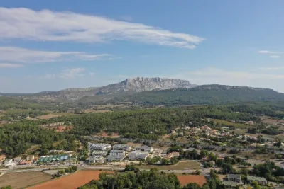
This massif is very popular with residents of the surrounding communes (Aix-en-Provence, Gardanne, Luynes and Bouc-Bel-Air) for sports and for admiring the view of Mont Sainte-Victoire
.Archaeology of the massif A path called the "Roman road" was discovered in 1975 on the east bank of the Vallon du Coq, which it climbs. It can be seen over a short distance, as its route is then lost in the vegetation and recent housing. It is very degraded and therefore not passable by vehicle. Its dating is uncertain.
Map and restricted areas
Open in the main mapNearby aerodromes
Open aerodromes within 25 km of the spot, heliports included, with their distance and direction from the spot. Near an aerodrome, drone flying is prohibited or height-limited: check the UAS zones map.
| Aerodrome | Type | Distance | Elevation | Difference |
|---|---|---|---|---|
| Pays d'Aix Medical Center Heliport | Heliport | 5.4 km NW | 222 m | spot 69 m higher |
| Aix - Les Milles Airport | Aerodrome | 8.2 km W | 112 m | spot 179 m higher |
| Nord Heliport | Heliport | 15 km SW | 187 m | spot 104 m higher |
| Marseille Provence Airport | Major airport | 21 km W | 23 m | spot 269 m higher |
| Berre/Marignane Seaplane Base | Seaplane base | 21 km W | 2 m | spot 289 m higher |
Aviation weather (METAR and TAF)
LFML – Marseille Provence Airport VFR
METAR
METAR LFML 222030Z AUTO 27020KT CAVOK 13/07 Q1016 BECMG 29020G30KT
- Wind
- 270°, 37 km/h
- Visibility
- 10 km or more
- Clouds
- –
- Temperature
- 13 °C, dew point 7 °C
- QNH
- 1016 hPa
- Flight category
- VFR: ceiling > 3,000 ft and visibility > 5 mi
TAF
TAF LFML 222000Z 2221/2403 29020G30KT CAVOK TX15/2314Z TN07/2403Z BECMG 2304/2306 32010KT TEMPO 2312/2314 30015G30KT BECMG 2316/2318 32015G30KT BECMG 2321/2323 33010KT
| Period (local time) | Change | Wind | Visibility | Weather | Clouds |
|---|---|---|---|---|---|
| 22/11 22:00 → 23/11 05:00 | Initial conditions | 290°, 37 km/h, gusts 56 km/h | 10 km or more | No significant cloud | |
| 23/11 05:00 → 23/11 17:00 | Becoming | 320°, 19 km/h | 10 km or more | No significant cloud | |
| 23/11 13:00 → 23/11 15:00 | Temporarily | 300°, 28 km/h, gusts 56 km/h | |||
| 23/11 17:00 → 23/11 22:00 | Becoming | 320°, 28 km/h, gusts 56 km/h | 10 km or more | No significant cloud | |
| 23/11 22:00 → 24/11 04:00 | Becoming | 330°, 19 km/h | 10 km or more | No significant cloud |
Weather and Kp index
| Day | Weather | Temp. min. / max. | Wind | Rain | Max Kp |
|---|---|---|---|---|---|
| Sun 22 Nov | Fair | 9° / 9° | 25 km/h W | – | 1 |
| Mon 23 Nov | Clear sky | 6° / 12° | 25 km/h W | – | 4 |
| Tue 24 Nov | Cloudy | 3° / 13° | 24 km/h E | 4.3 mm | 2 |
| Wed 25 Nov | Showers | 6° / 10° | 29 km/h E | 39 mm | 2 |
| Thu 26 Nov | Cloudy | 3° / 10° | 18 km/h NW | – | – |
| Fri 27 Nov | Clear sky | -1° / 9° | 10 km/h NW | – | – |
| Sat 28 Nov | Clear sky | -2° / 10° | 7 km/h W | – | – |
Hour by hour: Sunday 22 November
| Time | Weather | Temp. | Wind | Rain | Clouds | Kp |
|---|---|---|---|---|---|---|
| 22:00 | Fair | 9° | 24 km/h W | – | 19 % | 1 |
Hour by hour: Monday 23 November
| Time | Weather | Temp. | Wind | Rain | Clouds | Kp |
|---|---|---|---|---|---|---|
| 06:00 | Clear sky | 7° | 17 km/h NW | – | 5 % | 2 |
| 07:00 | Clear sky | 7° | 17 km/h NW | – | 11 % | 2 |
| 08:00 | Clear sky | 7° | 17 km/h NW | – | 10 % | 2 |
| 09:00 | Clear sky | 8° | 17 km/h W | – | 6 % | 2 |
| 10:00 | Fair | 10° | 16 km/h NW | – | 17 % | 2 |
| 11:00 | Fair | 11° | 19 km/h NW | – | 13 % | 2 |
| 12:00 | Fair | 12° | 22 km/h NW | – | 17 % | 2 |
| 13:00 | Clear sky | 12° | 24 km/h NW | – | 6 % | 4 |
| 14:00 | Fair | 12° | 24 km/h NW | – | 14 % | 4 |
| 15:00 | Fair | 12° | 23 km/h NW | – | 28 % | 4 |
| 16:00 | Fair | 11° | 21 km/h NW | – | 22 % | 4 |
| 17:00 | Fair | 10° | 17 km/h NW | – | 19 % | 4 |
| 18:00 | Partly cloudy | 9° | 15 km/h NW | – | 56 % | 4 |
| 19:00 | Partly cloudy | 9° | 16 km/h NW | – | 40 % | 3 |
| 20:00 | Partly cloudy | 8° | 15 km/h NW | – | 42 % | 3 |
| 21:00 | Partly cloudy | 8° | 15 km/h NW | – | 45 % | 3 |
| 22:00 | Fair | 7° | 16 km/h NW | – | 27 % | 2 |
Sunrise and sunset
| Day | Dawn | Sunrise | Golden hour | Sunset | Dusk | Day length |
|---|---|---|---|---|---|---|
| Sun 22 Nov | 07:09 | 07:41 | 07:41–08:25 · 16:24–17:08 | 17:08 | 17:39 | 9 h 27 |
| Mon 23 Nov | 07:10 | 07:42 | 07:42–08:26 · 16:23–17:07 | 17:07 | 17:39 | 9 h 25 |
| Tue 24 Nov | 07:12 | 07:43 | 07:43–08:28 · 16:22–17:07 | 17:07 | 17:38 | 9 h 23 |
| Wed 25 Nov | 07:13 | 07:44 | 07:44–08:29 · 16:21–17:06 | 17:06 | 17:38 | 9 h 21 |
| Thu 26 Nov | 07:14 | 07:45 | 07:45–08:30 · 16:21–17:05 | 17:05 | 17:37 | 9 h 20 |
| Fri 27 Nov | 07:15 | 07:47 | 07:47–08:32 · 16:20–17:05 | 17:05 | 17:37 | 9 h 18 |
| Sat 28 Nov | 07:16 | 07:48 | 07:48–08:33 · 16:19–17:04 | 17:04 | 17:36 | 9 h 16 |

Reviews
Log in to review this spot. Log in · Create a free account
No reviews yet. Share yours!