

Castle
No reviews yet
Have you flown here? Share your experience with other pilots.
+ Write the first reviewHistory
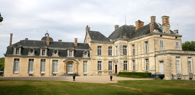
L'ensemble des bâtiments permet de comprendre la vie du château sur trois siècles. Reconstruit à partir de 1642, le château comprend un pavillon et deux ailes latérales. Une aile a été ajoutée par Voltaire en 1734-1735. Au 19e siècle, l'aile de Voltaire est complétée par une aile en retour, et une nouvelle chapelle est construite et décorée par le peintre Constant Ménissier (1851). Sur le site des anciens communs du château du 17e siècle, une grande cave formée de locaux voûtés en anse de panier et une fruiterie sont bâties. Distribués autour d'une cour rectangulaire, les communs se composent des écuries (1860) , du poulailler, du pigeonnier, du grenier à bois, du bâtiment du fermier, de la maison du berger, des granges et des étables. Dans le parc, présence d'un pont métallique (1880) et d'un chalet à décor de bois découpé caractéristique du goût de la fin du 19e siècle. Halle du haut fourneau reconstruite en 1855. Le bâtiment du directeur de la forge est caractéristique de l'architecture rurale de la fin du 18e siècle (moellons enduits, percements réguliers). Pavillons d'entrée construits en 1915.
Map and restricted areas
Open in the main mapRestricted zones
| Zone | Category | Limits | Conditions |
|---|---|---|---|
| Champagne | Zone réglementée | 244 m above ground level → 823 m above ground level | Vols interdits sauf lorsque the official document of the zone l'autorise explicitement ou avec l'accord du gestionnaire de la zone lorsqu'il est désigné par the official document of the zone |
Nearby aerodromes
Open aerodromes within 25 km of the spot, heliports included, with their distance and direction from the spot. Near an aerodrome, drone flying is prohibited or height-limited: check the UAS zones map.
| Aerodrome | Type | Distance | Elevation |
|---|---|---|---|
| Joinville Mussey Airfield | Aerodrome | 17 km NE | 312 m |
Aviation weather (METAR and TAF)
LFSI – Saint-Dizier-Robinson (BA 113) Air Base VFR
METAR
METAR LFSI 171400Z AUTO 24014KT 200V260 9999 BKN036 BKN150 BKN190 16/10 Q0994
- Wind
- 240°, 26 km/h
- Visibility
- 10 km or more
- Clouds
- Broken (5-7/8) at 3,600 ft (1100 m) ; Broken (5-7/8) at 15,000 ft (4570 m) ; Broken (5-7/8) at 19,000 ft (5790 m)
- Temperature
- 16 °C, dew point 10 °C
- QNH
- 994 hPa
- Flight category
- VFR: ceiling > 3,000 ft and visibility > 5 mi
TAF
TAF LFSI 171400Z 1715/1815 24015G25KT 9999 BKN030 TEMPO 1720/1724 21020G35KT 4000 SHRA BKN020 SCT030TCU TEMPO 1803/1808 4000 -SHRA SCT020TCU
| Period (local time) | Change | Wind | Visibility | Weather | Clouds |
|---|---|---|---|---|---|
| 17/11 16:00 → 18/11 16:00 | Initial conditions | 240°, 28 km/h, gusts 46 km/h | 10 km or more | Broken (5-7/8) at 3,000 ft (910 m) | |
| 17/11 21:00 → 18/11 01:00 | Temporarily | 210°, 37 km/h, gusts 65 km/h | 4.0 km | Showers of rain | Broken (5-7/8) at 2,000 ft (610 m) ; Scattered (3-4/8) at 3,000 ft (910 m) (towering cumulus) |
| 18/11 04:00 → 18/11 09:00 | Temporarily | 4.0 km | Showers of rain light | Scattered (3-4/8) at 2,000 ft (610 m) (towering cumulus) |
Weather and Kp index
Sunrise and sunset
| Day | Dawn | Sunrise | Golden hour | Sunset | Dusk | Day length |
|---|---|---|---|---|---|---|
| Tue 17 Nov | 07:16 | 07:51 | 07:51–08:40 · 16:11–17:00 | 17:00 | 17:34 | 9 h 09 |
| Wed 18 Nov | 07:18 | 07:52 | 07:52–08:42 · 16:09–16:59 | 16:59 | 17:33 | 9 h 06 |
| Thu 19 Nov | 07:19 | 07:54 | 07:54–08:43 · 16:08–16:58 | 16:58 | 17:32 | 9 h 04 |
| Fri 20 Nov | 07:21 | 07:55 | 07:55–08:45 · 16:07–16:57 | 16:57 | 17:31 | 9 h 01 |
| Sat 21 Nov | 07:22 | 07:57 | 07:57–08:47 · 16:06–16:56 | 16:56 | 17:30 | 8 h 59 |
| Sun 22 Nov | 07:23 | 07:58 | 07:58–08:48 · 16:04–16:55 | 16:55 | 17:30 | 8 h 56 |
| Mon 23 Nov | 07:25 | 07:59 | 07:59–08:50 · 16:03–16:54 | 16:54 | 17:29 | 8 h 54 |
Reviews (0)
Log in to review this spot. Log in · Create a free account
No reviews yet. Share yours!