

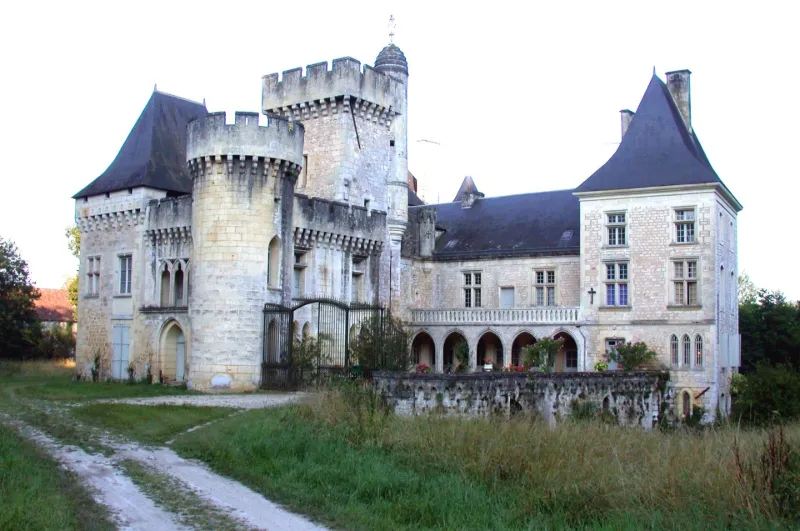
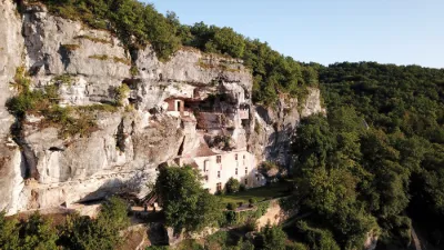
Campagne Castle Estate
No reviews yet
Have you flown here? Share your experience with other pilots.
+ Write the first reviewHistory
Mentionné dès le 12e siècle, le château remonte au 15e siècle pour sa partie la plus ancienne. L'aile au nord, avec une galerie ouverte sur cour, date du 17e siècle. L'ensemble a été restauré et mis au goût du jour entre 1854 et 1882. Des communs se développent au nord autour de trois cours. Le parc a été redessiné entre 1857 et 1862 par Jean-Jacques Rousseau, pépiniériste bordelais. La propriété du château (propriété de l'Etat - ministère de la culture) a été transférée au département le 1er juin 2007.
Map and restricted areas
Open in the main mapRestricted zones
| Zone | Category | Limits | Conditions |
|---|---|---|---|
| Zena Perigord Low | ZRT | FL 165 / FL 195 | SUP AIP 062/26 · Du jeudi 23 avril 2026 au jeudi 25 mars 2027 |
| Zena Perigord Medium | ZRT | FL 195 / FL 245 | SUP AIP 062/26 · Du jeudi 23 avril 2026 au jeudi 25 mars 2027 |
| Zena Perigord High | ZRT | FL 395 / UNL | SUP AIP 062/26 · Du jeudi 23 avril 2026 au jeudi 25 mars 2027 |
Nearby aerodromes
Open aerodromes within 25 km of the spot, heliports included, with their distance and direction from the spot. Near an aerodrome, drone flying is prohibited or height-limited: check the UAS zones map.
| Aerodrome | Type | Distance | Elevation |
|---|---|---|---|
| Aérodrome de Belvès Saint-Pardoux | Aerodrome | 14 km S | 241 m |
| Pressignac Vicq Rebeyrotte | Aerodrome | 17 km W | 196 m |
| La Canéda Centre Hospitalier Heliport | Heliport | 20 km E | 200 m |
Aviation weather (METAR and TAF)
LFBX – Périgueux-Bassillac Airport VFR
METAR
METAR LFBX 171400Z AUTO 22005KT 180V250 9999 SCT032 BKN039 OVC110 17/13 Q1002
- Wind
- 220°, 9 km/h
- Visibility
- 10 km or more
- Clouds
- Scattered (3-4/8) at 3,200 ft (980 m) ; Broken (5-7/8) at 3,900 ft (1190 m) ; Overcast (8/8) at 11,000 ft (3350 m)
- Temperature
- 17 °C, dew point 13 °C
- QNH
- 1002 hPa
- Flight category
- VFR: ceiling > 3,000 ft and visibility > 5 mi
TAF
Weather and Kp index
Sunrise and sunset
| Day | Dawn | Sunrise | Golden hour | Sunset | Dusk | Day length |
|---|---|---|---|---|---|---|
| Tue 17 Nov | 07:24 | 07:56 | 07:56–08:41 · 16:41–17:26 | 17:26 | 17:58 | 9 h 29 |
| Wed 18 Nov | 07:26 | 07:58 | 07:58–08:43 · 16:40–17:25 | 17:25 | 17:57 | 9 h 27 |
| Thu 19 Nov | 07:27 | 07:59 | 07:59–08:44 · 16:39–17:24 | 17:24 | 17:56 | 9 h 25 |
| Fri 20 Nov | 07:28 | 08:00 | 08:00–08:46 · 16:38–17:23 | 17:23 | 17:55 | 9 h 23 |
| Sat 21 Nov | 07:29 | 08:01 | 08:01–08:47 · 16:37–17:23 | 17:23 | 17:55 | 9 h 21 |
| Sun 22 Nov | 07:31 | 08:03 | 08:03–08:49 · 16:36–17:22 | 17:22 | 17:54 | 9 h 18 |
| Mon 23 Nov | 07:32 | 08:04 | 08:04–08:50 · 16:35–17:21 | 17:21 | 17:53 | 9 h 16 |
Reviews (0)
Log in to review this spot. Log in · Create a free account
No reviews yet. Share yours!