

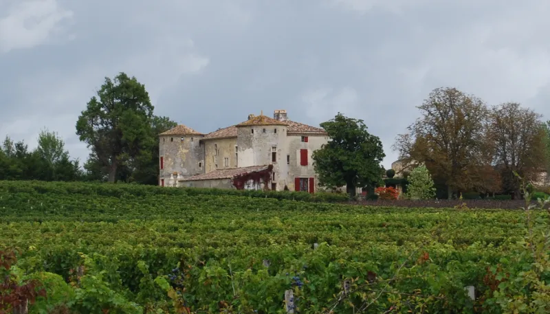
Châteauneuf Castle
No reviews yet
Have you flown here? Share your experience with other pilots.
+ Write the first reviewHistory
La demeure dépendit tout à tour du tribunal des moines de la Sauve-Majeure et de la prévôté royale d'Entre-Deux-Mers. La construction de l'édifice semble remonter à la seconde moitié du 16e siècle : tours, fenêtres à meneaux murées côté ouest, porte du côté Est surmontée d'une tête féminine. Les modifications successives s'échelonnent du 17e au 19e siècle, transformant l'ordonnance primitive pour lui donner son aspect actuel. Le logis rectangulaire est encadré, à l'ouest, par deux tours rondes. Côté Est, s'ouvre une porte à sommet cintré, encadrée d'impostes, de bossages en forte saillie, de deux têtes de lions, de lignes de refends, et coiffée d'un claveau saillant sculpté d'une tête de femme dont la coiffure évoque la seconde moitié du 16e siècle. L'ensemble est couronné d'un fronton courbe surmonté d'une corniche. Le perron côté sud comporte une balustrade en fer forgé du 18e siècle. A l'est, des communs et deux petites tours délimitent une cour dans laquelle une allée joignait le puits au logis. L'intérieur du logis conserve des cheminées du 19e siècle pour la plupart.£
Map and restricted areas
Open in the main mapRestricted zones
Nearby aerodromes
Open aerodromes within 25 km of the spot, heliports included, with their distance and direction from the spot. Near an aerodrome, drone flying is prohibited or height-limited: check the UAS zones map.
| Aerodrome | Type | Distance | Elevation |
|---|---|---|---|
| Base ULM de Arbis | Aerodrome | 11 km S | 61 m |
| Base ULM de Saint Pierre de Bat | Aerodrome | 13 km S | 48 m |
| Bordeaux Yvrac Airport | Aerodrome | 19 km NW | 73 m |
| Robert Piqué Hôpital Militaire Heliport | Heliport | 23 km W | 19 m |
Aviation weather (METAR and TAF)
LFBD – Bordeaux-Mérignac Airport VFR
METAR
METAR LFBD 171400Z AUTO 24011KT 9999 ///CB 17/14 Q1002 TEMPO 26015G25KT BECMG BKN020
- Wind
- 240°, 20 km/h
- Visibility
- 10 km or more
- Clouds
- –
- Temperature
- 17 °C, dew point 14 °C
- QNH
- 1002 hPa
- Flight category
- VFR: ceiling > 3,000 ft and visibility > 5 mi
TAF
TAF AMD LFBD 171410Z 1714/1818 26010KT 9999 BKN020 TX18/1714Z TN14/1802Z TEMPO 1714/1805 26015G35KT 4000 SHRA BKN010 FEW012CB BKN015TCU PROB30 TEMPO 1722/1801 26020G35KT 2000 TSRA BKN010 BKN015CB PROB30 TEMPO 1805/1815 26010G25KT 4000 -SHRA BKN030TCU BECMG 1816/1818 20005KT
| Period (local time) | Change | Wind | Visibility | Weather | Clouds |
|---|---|---|---|---|---|
| 17/11 15:00 → 18/11 17:00 | Initial conditions | 260°, 19 km/h | 10 km or more | Broken (5-7/8) at 2,000 ft (610 m) | |
| 17/11 15:00 → 18/11 06:00 | Temporarily | 260°, 28 km/h, gusts 65 km/h | 4.0 km | Showers of rain | Broken (5-7/8) at 1,000 ft (300 m) ; Few (1-2/8) at 1,200 ft (370 m) (cumulonimbus) ; Broken (5-7/8) at 1,500 ft (460 m) (towering cumulus) |
| 17/11 23:00 → 18/11 02:00 | Temporarily, probability 30% | 260°, 37 km/h, gusts 65 km/h | 2.0 km | Thunderstorm rain | Broken (5-7/8) at 1,000 ft (300 m) ; Broken (5-7/8) at 1,500 ft (460 m) (cumulonimbus) |
| 18/11 06:00 → 18/11 16:00 | Temporarily, probability 30% | 260°, 19 km/h, gusts 46 km/h | 4.0 km | Showers of rain light | Broken (5-7/8) at 3,000 ft (910 m) (towering cumulus) |
| 18/11 17:00 → 18/11 19:00 | Becoming | 200°, 9 km/h | 10 km or more | Broken (5-7/8) at 2,000 ft (610 m) |
Weather and Kp index
Sunrise and sunset
| Day | Dawn | Sunrise | Golden hour | Sunset | Dusk | Day length |
|---|---|---|---|---|---|---|
| Tue 17 Nov | 07:29 | 08:01 | 08:01–08:46 · 16:47–17:31 | 17:31 | 18:03 | 9 h 30 |
| Wed 18 Nov | 07:30 | 08:02 | 08:02–08:47 · 16:45–17:30 | 17:30 | 18:02 | 9 h 28 |
| Thu 19 Nov | 07:32 | 08:03 | 08:03–08:49 · 16:44–17:30 | 17:30 | 18:01 | 9 h 26 |
| Fri 20 Nov | 07:33 | 08:05 | 08:05–08:50 · 16:43–17:29 | 17:29 | 18:01 | 9 h 23 |
| Sat 21 Nov | 07:34 | 08:06 | 08:06–08:52 · 16:42–17:28 | 17:28 | 18:00 | 9 h 21 |
| Sun 22 Nov | 07:35 | 08:07 | 08:07–08:53 · 16:41–17:27 | 17:27 | 17:59 | 9 h 19 |
| Mon 23 Nov | 07:36 | 08:09 | 08:09–08:54 · 16:41–17:26 | 17:26 | 17:59 | 9 h 17 |

Reviews (0)
Log in to review this spot. Log in · Create a free account
No reviews yet. Share yours!