

Léonardsau Estate
No reviews yet
Have you flown here? Share your experience with other pilots.
+ Write the first reviewHistory
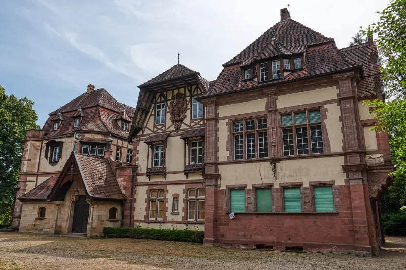
Le domaine est acheté en 1896 par le baron Albert-Louis-Eugène de Dietrich (1861-1957) qui fait construire le château actuel par étapes successives : la villa formant la partie centrale du château de 1899 à 1900, l'aile ouest de 1909 à 1910 et la salle à manger du jardin en 1921. L'ensemble est réalisé dans le goût de la Renaissance avec de nombreux éléments de remploi. L'un des salons de la villa est décoré par le peintre Charles Spindler en 1902, dans un style influencé par l'Art Nouveau. Le parc de neuf hectares, dessiné par le paysagiste belge Jules Buyssens, en collaboration avec le baron, comporte des éléments d'un parc anglais, d'un jardin à la française et des microcosmes de jardins italiens et japonais. Interventions de René-Edouard André dans le parc. Le domaine a été acquis par la ville en 1970.
Map and restricted areas
Open in the main mapRestricted zones
| Zone | Category | Limits | Conditions |
|---|---|---|---|
| Colmar Nord | Zone réglementée | 4272 m above sea level → 6259 m above sea level | Vols interdits sauf lorsque the official document of the zone l'autorise explicitement ou avec l'accord du gestionnaire de la zone lorsqu'il est désigné par the official document of the zone |
Nearby aerodromes
Open aerodromes within 25 km of the spot, heliports included, with their distance and direction from the spot. Near an aerodrome, drone flying is prohibited or height-limited: check the UAS zones map.
| Aerodrome | Type | Distance | Elevation |
|---|---|---|---|
| Strasbourg Airport | Airport | 16 km NE | 154 m |
| Aérodrome d'Albé - Val de Villé | Aerodrome | 16 km SW | 380 m |
| Club ULM de Kogenheim | Aerodrome | 18 km S | 161 m |
| Graffenstaden Centre Hospitalier Heliport | Heliport | 22 km E | 157 m |
| Centre Hospitalier Hautepierre Heliport | Heliport | 24 km NE | 148 m |
Aviation weather (METAR and TAF)
LFST – Strasbourg Airport VFR
METAR
METAR LFST 171330Z AUTO 23021G31KT 9999 BKN043 OVC051 OVC060 18/10 Q0994 TEMPO FEW030TCU BECMG 20012KT
- Wind
- 230°, 39 km/h, gusts 57 km/h
- Visibility
- 10 km or more
- Clouds
- Broken (5-7/8) at 4,300 ft (1310 m) ; Overcast (8/8) at 5,100 ft (1550 m) ; Overcast (8/8) at 6,000 ft (1830 m)
- Temperature
- 18 °C, dew point 10 °C
- QNH
- 994 hPa
- Flight category
- VFR: ceiling > 3,000 ft and visibility > 5 mi
TAF
TAF LFST 171100Z 1712/1812 20012KT 9999 BKN035 TEMPO 1712/1715 23020G35KT -SHRA FEW030TCU TEMPO 1721/1804 22015G25KT -SHRA SCT030TCU PROB40 TEMPO 1722/1802 24020G35KT 4000 SHRA SCT025CB
| Period (local time) | Change | Wind | Visibility | Weather | Clouds |
|---|---|---|---|---|---|
| 17/11 13:00 → 18/11 13:00 | Initial conditions | 200°, 22 km/h | 10 km or more | Broken (5-7/8) at 3,500 ft (1070 m) | |
| 17/11 13:00 → 17/11 16:00 | Temporarily | 230°, 37 km/h, gusts 65 km/h | Showers of rain light | Few (1-2/8) at 3,000 ft (910 m) (towering cumulus) | |
| 17/11 22:00 → 18/11 05:00 | Temporarily | 220°, 28 km/h, gusts 46 km/h | Showers of rain light | Scattered (3-4/8) at 3,000 ft (910 m) (towering cumulus) | |
| 17/11 23:00 → 18/11 03:00 | Temporarily, probability 40% | 240°, 37 km/h, gusts 65 km/h | 4.0 km | Showers of rain | Scattered (3-4/8) at 2,500 ft (760 m) (cumulonimbus) |
Weather and Kp index
| Day | Weather | Temp. min. / max. | Wind | Rain | Max Kp |
|---|---|---|---|---|---|
| Tue 17 Nov | Cloudy | 11° / 14° | 32 km/h SW | 2.9 mm | 5 |
| Wed 18 Nov | Light rain | 8° / 12° | 32 km/h W | 7.3 mm | 5 |
| Thu 19 Nov | Light rain | 7° / 11° | 28 km/h W | 12 mm | 3 |
| Fri 20 Nov | Light rain | 8° / 10° | 26 km/h SW | 11 mm | 3 |
| Sat 21 Nov | Partly cloudy | 6° / 9° | 16 km/h W | 8.4 mm | – |
| Sun 22 Nov | Rain | 3° / 6° | 8 km/h SW | 8.5 mm | – |
| Mon 23 Nov | Light rain | 6° / 9° | 16 km/h W | 2.5 mm | – |
Hour by hour: Tuesday 17 November
| Time | Weather | Temp. | Wind | Rain | Clouds | Kp |
|---|---|---|---|---|---|---|
| 15:00 | Cloudy | 14° | 32 km/h SW | – | 100 % | 4 |
| 16:00 | Cloudy | 14° | 29 km/h SW | – | 99 % | 4 |
| 17:00 | Cloudy | 14° | 27 km/h SW | – | 90 % | 4 |
| 18:00 | Partly cloudy | 13° | 24 km/h SW | – | 58 % | 4 |
| 19:00 | Partly cloudy | 13° | 27 km/h SW | – | 85 % | 5 |
| 20:00 | Cloudy | 14° | 28 km/h SW | – | 89 % | 5 |
| 21:00 | Cloudy | 13° | 30 km/h SW | – | 99 % | 5 |
| 22:00 | Rain | 13° | 28 km/h SW | 0.8 mm | 91 % | 5 |
Hour by hour: Wednesday 18 November
| Time | Weather | Temp. | Wind | Rain | Clouds | Kp |
|---|---|---|---|---|---|---|
| 06:00 | Light rain | 10° | 25 km/h SW | 0.4 mm | 100 % | 4 |
| 07:00 | Rain | 10° | 27 km/h SW | 0.4 mm | 100 % | 4 |
| 08:00 | Light rain | 10° | 26 km/h W | 0.3 mm | 100 % | 4 |
| 09:00 | Rain | 10° | 27 km/h W | 0.4 mm | 100 % | 4 |
| 10:00 | Rain | 10° | 29 km/h W | 0.6 mm | 100 % | 4 |
| 11:00 | Rain | 11° | 32 km/h W | 0.7 mm | 99 % | 4 |
| 12:00 | Rain | 11° | 31 km/h W | 0.5 mm | 95 % | 4 |
| 13:00 | Light rain | 11° | 30 km/h W | 0.2 mm | 88 % | 3 |
| 14:00 | Showers | 12° | 30 km/h W | 0.2 mm | 85 % | 3 |
| 15:00 | Cloudy | 11° | 28 km/h W | – | 93 % | 3 |
| 16:00 | Cloudy | 11° | 30 km/h W | – | 88 % | 3 |
| 17:00 | Light rain | 11° | 27 km/h W | 0.2 mm | 92 % | 3 |
| 18:00 | Light rain | 10° | 27 km/h SW | 0.1 mm | 99 % | 3 |
| 19:00 | Partly cloudy | 10° | 25 km/h SW | – | 79 % | 2 |
| 20:00 | Light rain | 10° | 24 km/h SW | 0.1 mm | 91 % | 2 |
| 21:00 | Showers | 9° | 21 km/h SW | 0.1 mm | 56 % | 2 |
| 22:00 | Partly cloudy | 8° | 18 km/h SW | – | 66 % | 2 |
Sunrise and sunset
| Day | Dawn | Sunrise | Golden hour | Sunset | Dusk | Day length |
|---|---|---|---|---|---|---|
| Tue 17 Nov | 07:07 | 07:41 | 07:41–08:30 · 16:00–16:49 | 16:49 | 17:24 | 9 h 08 |
| Wed 18 Nov | 07:08 | 07:43 | 07:43–08:32 · 15:59–16:48 | 16:48 | 17:23 | 9 h 05 |
| Thu 19 Nov | 07:09 | 07:44 | 07:44–08:34 · 15:57–16:47 | 16:47 | 17:22 | 9 h 03 |
| Fri 20 Nov | 07:11 | 07:46 | 07:46–08:36 · 15:56–16:46 | 16:46 | 17:21 | 9 h 00 |
| Sat 21 Nov | 07:12 | 07:47 | 07:47–08:37 · 15:55–16:45 | 16:45 | 17:20 | 8 h 58 |
| Sun 22 Nov | 07:14 | 07:48 | 07:48–08:39 · 15:54–16:44 | 16:44 | 17:19 | 8 h 55 |
| Mon 23 Nov | 07:15 | 07:50 | 07:50–08:41 · 15:53–16:43 | 16:43 | 17:18 | 8 h 53 |


Reviews (0)
Log in to review this spot. Log in · Create a free account
No reviews yet. Share yours!