

Porhman Castle
No reviews yet
Have you flown here? Share your experience with other pilots.
+ Write the first reviewHistory
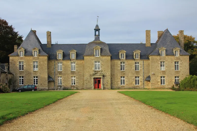
Château en granit construit à la fin du 17e siècle. Un seul corps de bâtiment comprenant rez-de-chaussée, étage et comble, flanqué aux extrémités de deux pavillons légèrement saillants, sur les deux faces. Un pavillon central surmonté d'un clocheton fait saillie du côté de la cour d'honneur. L'entrée est accusée par un fronton. A l'autre extrémité de la cour d'honneur, deux pilastres surmontés de motifs sculptés accusent l'entrée. Une aile de communs de même construction borde un côté de la cour. A l'intérieur, occupant tout le pavillon central, un escalier en granit dont les marches reposent sur des arcs supportés par quatre piliers. Le château appartenait à la seigneurie de Rohan.
Map and restricted areas
Open in the main mapRestricted zones
| Zone | Category | Limits | Conditions |
|---|---|---|---|
| Loudeac | Zone réglementée | 1372 m above sea level → 3821 m above sea level | Vols interdits sauf lorsque the official document of the zone l'autorise explicitement ou avec l'accord du gestionnaire de la zone lorsqu'il est désigné par the official document of the zone |
| Loudeac | Zone réglementée | 3053 m above sea level → 6259 m above sea level | Vols interdits sauf lorsque the official document of the zone l'autorise explicitement ou avec l'accord du gestionnaire de la zone lorsqu'il est désigné par the official document of the zone |
| Argoat | Zone réglementée | 3053 m above sea level → 6259 m above sea level | Vols interdits sauf lorsque the official document of the zone l'autorise explicitement ou avec l'accord du gestionnaire de la zone lorsqu'il est désigné par the official document of the zone |
Nearby aerodromes
Open aerodromes within 25 km of the spot, heliports included, with their distance and direction from the spot. Near an aerodrome, drone flying is prohibited or height-limited: check the UAS zones map.
| Aerodrome | Type | Distance | Elevation |
|---|---|---|---|
| Pontivy Airport | Aerodrome | 12 km NW | 124 m |
Aviation weather (METAR and TAF)
LFRV – Vannes-Meucon Airport MVFR
METAR
METAR LFRV 171400Z AUTO 23017G30KT 190V270 8000 BKN014 OVC100 15/12 Q0991
- Wind
- 230°, 31 km/h, gusts 56 km/h
- Visibility
- 8 km
- Clouds
- Broken (5-7/8) at 1,400 ft (430 m) ; Overcast (8/8) at 10,000 ft (3050 m)
- Temperature
- 15 °C, dew point 12 °C
- QNH
- 991 hPa
- Flight category
- MVFR: ceiling 1,000–3,000 ft or visibility 3–5 mi
TAF
Weather and Kp index
Sunrise and sunset
| Day | Dawn | Sunrise | Golden hour | Sunset | Dusk | Day length |
|---|---|---|---|---|---|---|
| Tue 17 Nov | 07:47 | 08:21 | 08:21–09:09 · 16:43–17:32 | 17:32 | 18:06 | 9 h 11 |
| Wed 18 Nov | 07:48 | 08:22 | 08:22–09:11 · 16:42–17:31 | 17:31 | 18:05 | 9 h 08 |
| Thu 19 Nov | 07:49 | 08:23 | 08:23–09:13 · 16:40–17:30 | 17:30 | 18:04 | 9 h 06 |
| Fri 20 Nov | 07:51 | 08:25 | 08:25–09:14 · 16:39–17:29 | 17:29 | 18:03 | 9 h 03 |
| Sat 21 Nov | 07:52 | 08:26 | 08:26–09:16 · 16:38–17:28 | 17:28 | 18:02 | 9 h 01 |
| Sun 22 Nov | 07:53 | 08:28 | 08:28–09:18 · 16:37–17:27 | 17:27 | 18:01 | 8 h 59 |
| Mon 23 Nov | 07:55 | 08:29 | 08:29–09:19 · 16:36–17:26 | 17:26 | 18:01 | 8 h 56 |
Reviews (0)
Log in to review this spot. Log in · Create a free account
No reviews yet. Share yours!