

Former Charterhouse of Saix
No reviews yet
Have you flown here? Share your experience with other pilots.
+ Write the first reviewHistory
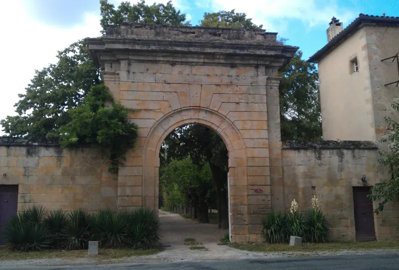
En 1359, Raymond de Saysse offre à l'évêque la libre disposition de ses terres en vue d'une fondation cartusienne, qui prendra le nom de Belvèse. Cette chartreuse s'agrandit au 15e siècle de la chartreuse de Loupiatière près de Carcassonne. Chassés de Saix par les guerres de Religion en 1567, les Chartreux se réfugièrent à Toulouse où ils fondèrent Saint-Pierre des Chartreux. De retour en 1574, ils reprennent la construction qui ne s'achèvera qu'en 1674. De cette chartreuse ne subsiste que le mur de clôture. Tous les bâtiments conventuels ont été rasés à la Révolution, et leurs matériaux pillés. Une grande porte d'entrée en pierres de taille, en chainage, constituée par un cintre surmonté d'une puissante corniche, dans le style Louis XIV, donnait accès à l'intérieur, vers l'église. Le long des côtés du mur de clôture et à chaque angle, des tours carrées de deux étages comportent deux salles superposées, voûtées d'arêtes (anciennes cellules de moines), reliées par un escalier à vis. A l'ouest, dans la courbe de la rivière, se trouve le vivier.
Map and restricted areas
Open in the main mapRestricted zones
| Zone | Category | Limits | Conditions |
|---|---|---|---|
| Tma Toulouse |
Région de contrôle terminal | 457 m above ground level → 2297 m above sea level · 610 m above sea level → 914 m above sea level · 610 m above sea level → 2297 m above sea level · 732 m above sea level → 914 m above sea level · 762 m above sea level → 2297 m above sea level · 914 m above sea level → 1219 m above sea level · 914 m above sea level → 1219 m above sea level · 914 m above sea level → 2297 m above sea level · 914 m above sea level → 2297 m above sea level · 914 m above sea level → 2297 m above sea level · 1067 m above sea level → 2297 m above sea level · 1067 m above sea level → 3821 m above sea level · 1219 m above sea level → 2297 m above sea level · 1219 m above sea level → 2297 m above sea level · 1219 m above sea level → 2297 m above sea level · 1529 m above sea level → 3821 m above sea level · 1529 m above sea level → 3821 m above sea level · 1529 m above sea level → 3821 m above sea level | Drone flights inside this zone are forbidden without the prior agreement of air traffic control |
| Istres | Zone réglementée | 5491 m above sea level → 30766 m above sea level | Vols interdits sauf lorsque the official document of the zone l'autorise explicitement ou avec l'accord du gestionnaire de la zone lorsqu'il est désigné par the official document of the zone |
Nearby aerodromes
Open aerodromes within 25 km of the spot, heliports included, with their distance and direction from the spot. Near an aerodrome, drone flying is prohibited or height-limited: check the UAS zones map.
| Aerodrome | Type | Distance | Elevation |
|---|---|---|---|
| Centre Hospitalier Heliport | Heliport | 4.8 km E | 196 m |
| Castres-Mazamet Airport | Airport | 9.4 km SE | 240 m |
| Revel Montgey Airfield | Aerodrome | 20 km SW | 196 m |
| Aérodrome de Graulhet-Montdragon | Aerodrome | 24 km NW | 177 m |
Aviation weather (METAR and TAF)
LFCK – Castres-Mazamet Airport VFR
METAR
METAR LFCK 171400Z AUTO 08005KT 050V130 9999 SCT036/// SCT100/// BKN130/// ///CB 15/14 Q1005 TEMPO VRB15G25KT 4000 SHRA
- Wind
- 080°, 9 km/h
- Visibility
- 10 km or more
- Clouds
- Scattered (3-4/8) at 3,600 ft (1100 m) ; Scattered (3-4/8) at 10,000 ft (3050 m) ; Broken (5-7/8) at 13,000 ft (3960 m)
- Temperature
- 15 °C, dew point 14 °C
- QNH
- 1005 hPa
- Flight category
- VFR: ceiling > 3,000 ft and visibility > 5 mi
TAF
TAF LFCK 171100Z 1712/1721 12004KT CAVOK TEMPO 1712/1721 VRB15G25KT 4000 SHRA BKN018 BKN040TCU FEW070CB
| Period (local time) | Change | Wind | Visibility | Weather | Clouds |
|---|---|---|---|---|---|
| 17/11 13:00 → 17/11 22:00 | Initial conditions | 120°, 7 km/h | 10 km or more | No significant weather | No significant cloud |
| 17/11 13:00 → 17/11 22:00 | Temporarily | Variable, 28 km/h, gusts 46 km/h | 4.0 km | Showers of rain | Broken (5-7/8) at 1,800 ft (550 m) ; Broken (5-7/8) at 4,000 ft (1220 m) (towering cumulus) ; Few (1-2/8) at 7,000 ft (2130 m) (cumulonimbus) |
Weather and Kp index
Sunrise and sunset
| Day | Dawn | Sunrise | Golden hour | Sunset | Dusk | Day length |
|---|---|---|---|---|---|---|
| Tue 17 Nov | 07:17 | 07:48 | 07:48–08:31 · 16:41–17:25 | 17:25 | 17:56 | 9 h 36 |
| Wed 18 Nov | 07:18 | 07:49 | 07:49–08:33 · 16:40–17:24 | 17:24 | 17:55 | 9 h 34 |
| Thu 19 Nov | 07:19 | 07:50 | 07:50–08:34 · 16:39–17:23 | 17:23 | 17:54 | 9 h 32 |
| Fri 20 Nov | 07:20 | 07:52 | 07:52–08:36 · 16:38–17:22 | 17:22 | 17:53 | 9 h 30 |
| Sat 21 Nov | 07:21 | 07:53 | 07:53–08:37 · 16:37–17:21 | 17:21 | 17:53 | 9 h 28 |
| Sun 22 Nov | 07:23 | 07:54 | 07:54–08:38 · 16:36–17:21 | 17:21 | 17:52 | 9 h 26 |
| Mon 23 Nov | 07:24 | 07:55 | 07:55–08:40 · 16:36–17:20 | 17:20 | 17:52 | 9 h 24 |
Reviews (0)
Log in to review this spot. Log in · Create a free account
No reviews yet. Share yours!