

Saint-Angel Mill
No reviews yet
Have you flown here? Share your experience with other pilots.
+ Write the first reviewHistory
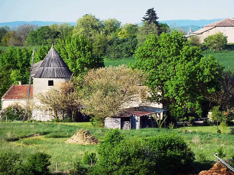
Connue aussi sous le nom de moulin de Saint-Angel, cette tour tronconique sur butte artificielle, construite en brique avec de rares assises en pierre, portait l'inscription "achetté en 1759", gravée sur une brique scellée au dessus de la porte d'entrée. Cette date, aujourd'hui disparue, est rappelée par un écriteau à l'intérieur de la salle en rez-de-chaussée surélevé, équipée de deux paires de meules. Jadis une paire de meules était située à l'étage, comme en témoignent les empreintes de l'escalier suspendu laissées dans la maçonnerie et les ouvertures. Vers 1940, un moteur à essence remplace l'énergie éolienne. Le moulin cesse son activité quelques années plus tard en 1951 ; la toiture et les ailes sont refaites en 1979. Ce moulin a été consolidé à sa base par un cerclage en fer, après la tempête de décembre 1999.
Map and restricted areas
Open in the main mapRestricted zones
Nearby aerodromes
Open aerodromes within 25 km of the spot, heliports included, with their distance and direction from the spot. Near an aerodrome, drone flying is prohibited or height-limited: check the UAS zones map.
| Aerodrome | Type | Distance | Elevation |
|---|---|---|---|
| Aérodrome de Gaillac - Lisle-sur-Tarn | Aerodrome | 19 km E | 136 m |
| Base ULM de Labastide St Sernin | Aerodrome | 24 km SW | 152 m |
Aviation weather (METAR and TAF)
LFBO – Toulouse-Blagnac Airport MVFR
METAR
METAR LFBO 171330Z AUTO 03004KT 320V080 9999 OVC024 14/13 Q1004 TEMPO 4000 RA BKN010
- Wind
- 030°, 7 km/h
- Visibility
- 10 km or more
- Clouds
- Overcast (8/8) at 2,400 ft (730 m)
- Temperature
- 14 °C, dew point 13 °C
- QNH
- 1004 hPa
- Flight category
- MVFR: ceiling 1,000–3,000 ft or visibility 3–5 mi
TAF
TAF LFBO 171100Z 1712/1818 18006KT 9999 BKN038 TEMPO 1712/1717 4000 RA BKN010 TEMPO 1717/1720 8000 -RA BKN014 BECMG 1720/1722 CAVOK BECMG 1803/1805 33006KT BECMG 1805/1807 4000 -RA BKN013 BKN040 BECMG 1807/1809 25010KT BECMG 1809/1811 9999 NSW BKN030 BECMG 1816/1818 19006KT CAVOK
| Period (local time) | Change | Wind | Visibility | Weather | Clouds |
|---|---|---|---|---|---|
| 17/11 13:00 → 17/11 21:00 | Initial conditions | 180°, 11 km/h | 10 km or more | Broken (5-7/8) at 3,800 ft (1160 m) | |
| 17/11 13:00 → 17/11 18:00 | Temporarily | 4.0 km | Rain | Broken (5-7/8) at 1,000 ft (300 m) | |
| 17/11 18:00 → 17/11 21:00 | Temporarily | 8 km | Rain light | Broken (5-7/8) at 1,400 ft (430 m) | |
| 17/11 21:00 → 18/11 04:00 | Becoming | 180°, 11 km/h | 10 km or more | No significant weather | No significant cloud |
| 18/11 04:00 → 18/11 06:00 | Becoming | 330°, 11 km/h | 10 km or more | No significant weather | No significant cloud |
| 18/11 06:00 → 18/11 08:00 | Becoming | 330°, 11 km/h | 4.0 km | Rain light | Broken (5-7/8) at 1,300 ft (400 m) ; Broken (5-7/8) at 4,000 ft (1220 m) |
| 18/11 08:00 → 18/11 10:00 | Becoming | 250°, 19 km/h | 4.0 km | Rain light | Broken (5-7/8) at 1,300 ft (400 m) ; Broken (5-7/8) at 4,000 ft (1220 m) |
| 18/11 10:00 → 18/11 17:00 | Becoming | 250°, 19 km/h | 10 km or more | No significant weather | Broken (5-7/8) at 3,000 ft (910 m) |
| 18/11 17:00 → 18/11 19:00 | Becoming | 190°, 11 km/h | 10 km or more | No significant weather | No significant cloud |
Weather and Kp index
| Day | Weather | Temp. min. / max. | Wind | Rain | Max Kp |
|---|---|---|---|---|---|
| Tue 17 Nov | Heavy rain | 11° / 14° | 14 km/h S | 12 mm | 5 |
| Wed 18 Nov | Clear sky | 11° / 17° | 22 km/h W | 4.8 mm | 5 |
| Thu 19 Nov | Fair | 10° / 14° | 28 km/h W | 11 mm | 3 |
| Fri 20 Nov | Partly cloudy | 9° / 15° | 23 km/h W | 2.5 mm | 3 |
| Sat 21 Nov | Cloudy | 7° / 15° | 14 km/h E | 0.2 mm | – |
| Sun 22 Nov | Showers | 11° / 13° | 19 km/h W | 6.4 mm | – |
| Mon 23 Nov | Cloudy | 7° / 13° | 12 km/h W | – | – |
Hour by hour: Tuesday 17 November
| Time | Weather | Temp. | Wind | Rain | Clouds | Kp |
|---|---|---|---|---|---|---|
| 15:00 | Heavy rain | 14° | 9 km/h SW | 1.1 mm | 100 % | 4 |
| 16:00 | Rain | 13° | 5 km/h SE | 0.6 mm | 100 % | 4 |
| 17:00 | Cloudy | 13° | 5 km/h NE | – | 99 % | 4 |
| 18:00 | Heavy rain | 12° | 10 km/h NE | 4.1 mm | 100 % | 4 |
| 19:00 | Heavy rain | 12° | 8 km/h NE | 1.9 mm | 99 % | 5 |
| 20:00 | Heavy rain | 11° | 7 km/h SE | 1.3 mm | 100 % | 5 |
| 21:00 | Rain | 11° | 10 km/h S | 1.0 mm | 100 % | 5 |
| 22:00 | Rain | 11° | 13 km/h S | 0.6 mm | 100 % | 5 |
Hour by hour: Wednesday 18 November
| Time | Weather | Temp. | Wind | Rain | Clouds | Kp |
|---|---|---|---|---|---|---|
| 06:00 | Cloudy | 13° | 19 km/h W | – | 99 % | 4 |
| 07:00 | Cloudy | 13° | 22 km/h W | – | 93 % | 4 |
| 08:00 | Cloudy | 13° | 22 km/h W | – | 99 % | 4 |
| 09:00 | Partly cloudy | 14° | 20 km/h W | – | 66 % | 4 |
| 10:00 | Light rain | 14° | 18 km/h W | 0.3 mm | 100 % | 4 |
| 11:00 | Fair | 14° | 18 km/h SW | – | 34 % | 4 |
| 12:00 | Fair | 15° | 19 km/h SW | – | 23 % | 4 |
| 13:00 | Clear sky | 16° | 20 km/h SW | – | 11 % | 3 |
| 14:00 | Fair | 17° | 22 km/h W | – | 24 % | 3 |
| 15:00 | Clear sky | 17° | 17 km/h W | – | 7 % | 3 |
| 16:00 | Clear sky | 16° | 11 km/h W | – | 12 % | 3 |
| 17:00 | Partly cloudy | 14° | 5 km/h SW | – | 73 % | 3 |
| 18:00 | Partly cloudy | 12° | 6 km/h S | – | 98 % | 3 |
| 19:00 | Partly cloudy | 12° | 8 km/h SE | – | 100 % | 2 |
| 20:00 | Partly cloudy | 12° | 14 km/h SE | – | 84 % | 2 |
| 21:00 | Cloudy | 12° | 17 km/h SE | – | 100 % | 2 |
| 22:00 | Rain | 12° | 20 km/h SE | 0.5 mm | 98 % | 2 |
Sunrise and sunset
| Day | Dawn | Sunrise | Golden hour | Sunset | Dusk | Day length |
|---|---|---|---|---|---|---|
| Tue 17 Nov | 07:20 | 07:51 | 07:51–08:35 · 16:42–17:26 | 17:26 | 17:57 | 9 h 35 |
| Wed 18 Nov | 07:21 | 07:52 | 07:52–08:36 · 16:41–17:25 | 17:25 | 17:56 | 9 h 33 |
| Thu 19 Nov | 07:22 | 07:53 | 07:53–08:38 · 16:40–17:24 | 17:24 | 17:56 | 9 h 31 |
| Fri 20 Nov | 07:23 | 07:55 | 07:55–08:39 · 16:39–17:24 | 17:24 | 17:55 | 9 h 28 |
| Sat 21 Nov | 07:24 | 07:56 | 07:56–08:40 · 16:38–17:23 | 17:23 | 17:54 | 9 h 26 |
| Sun 22 Nov | 07:26 | 07:57 | 07:57–08:42 · 16:37–17:22 | 17:22 | 17:54 | 9 h 24 |
| Mon 23 Nov | 07:27 | 07:58 | 07:58–08:43 · 16:36–17:21 | 17:21 | 17:53 | 9 h 23 |

Reviews (0)
Log in to review this spot. Log in · Create a free account
No reviews yet. Share yours!