

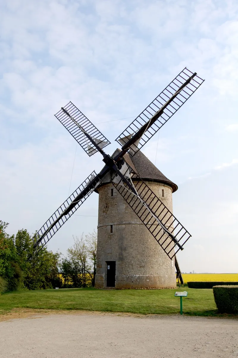
Frouville-Pensier Windmill
No reviews yet
Have you flown here? Share your experience with other pilots.
+ Write the first reviewHistory
La présence d'un moulin est attestée à cet emplacement dès le 13e siècle. Le moulin-tour se compose d'un soubassement en pierre de taille. Les murs construits en moëllons sont étayés par des chaînes de pierre harpées et sont cintrés au milieu par un bandeau de pierre. Des plaques de pierre gravées placées au-dessus de la porte d'entrée, indiquent l'année de construction et le nom du meunier qui a fait édifier le moulin. La toiture du moulin pivote sur des rails, lui permettant ainsi d'être orientée. A l'origine, une queue s'emboîtait dans la calotte du toit et permettait de faire pivoter toute la toiture suivant l'orientation du vent. A la fin du 19e siècle, aménagement d'un système de commande pour faire pivoter la toiture (treuil d'orientation intérieur). A l'intérieur, trois niveaux subsistent, reliés par un escalier.
Map and restricted areas
Open in the main mapRestricted zones
| Zone | Category | Limits | Conditions |
|---|---|---|---|
| Tma Orleans |
Région de contrôle terminal | 457 m above sea level → 2297 m above sea level · 457 m above sea level → 2297 m above sea level · 457 m above sea level → 2297 m above sea level · 1067 m above sea level → 2297 m above sea level · 1067 m above sea level → 2297 m above sea level · 1372 m above sea level → 2297 m above sea level · 1372 m above sea level → 3821 m above sea level · 1529 m above sea level → 3821 m above sea level · 3053 m above sea level → 4735 m above sea level · 3967 m above sea level → 6259 m above sea level | Drone flights inside this zone are forbidden without the prior agreement of air traffic control |
| Paris 7 | Zone réglementée | 1529 m above sea level → 2907 m above sea level | Vols interdits sauf lorsque the official document of the zone l'autorise explicitement ou avec l'accord du gestionnaire de la zone lorsqu'il est désigné par the official document of the zone |
| Paris 9 | Zone réglementée | 2138 m above sea level → 3821 m above sea level | Vols interdits sauf lorsque the official document of the zone l'autorise explicitement ou avec l'accord du gestionnaire de la zone lorsqu'il est désigné par the official document of the zone |
Nearby aerodromes
Open aerodromes within 25 km of the spot, heliports included, with their distance and direction from the spot. Near an aerodrome, drone flying is prohibited or height-limited: check the UAS zones map.
| Aerodrome | Type | Distance | Elevation |
|---|---|---|---|
| Châteaudun (BA 279) Air Base | Airport | 7.0 km NW | 132 m |
| Orléans-Bricy (BA 123) Air Base | Airport | 23 km E | 126 m |
Aviation weather (METAR and TAF)
LFOJ – Orléans-Bricy (BA 123) Air Base VFR
METAR
METAR LFOJ 171400Z AUTO 22022KT 9999 FEW032 BKN150 BKN180 15/11 Q0993 TEMPO 24025G35KT
- Wind
- 220°, 41 km/h
- Visibility
- 10 km or more
- Clouds
- Few (1-2/8) at 3,200 ft (980 m) ; Broken (5-7/8) at 15,000 ft (4570 m) ; Broken (5-7/8) at 18,000 ft (5490 m)
- Temperature
- 15 °C, dew point 11 °C
- QNH
- 993 hPa
- Flight category
- VFR: ceiling > 3,000 ft and visibility > 5 mi
TAF
TAF LFOJ 170800Z 1709/1809 24020KT 9999 BKN025 TX17/1714Z TN10/1800Z TEMPO 1709/1718 24025G35KT TEMPO 1718/1720 25030G45KT 4000 RA PROB40 TEMPO 1719/1720 2000 -TSRA BKN025 SCT030CB PROB30 TEMPO 1802/1809 25020G35KT 4000 SHRA SCT030TCU
| Period (local time) | Change | Wind | Visibility | Weather | Clouds |
|---|---|---|---|---|---|
| 17/11 10:00 → 18/11 10:00 | Initial conditions | 240°, 37 km/h | 10 km or more | Broken (5-7/8) at 2,500 ft (760 m) | |
| 17/11 10:00 → 17/11 19:00 | Temporarily | 240°, 46 km/h, gusts 65 km/h | |||
| 17/11 19:00 → 17/11 21:00 | Temporarily | 250°, 56 km/h, gusts 83 km/h | 4.0 km | Rain | |
| 17/11 20:00 → 17/11 21:00 | Temporarily, probability 40% | 2.0 km | Thunderstorm rain light | Broken (5-7/8) at 2,500 ft (760 m) ; Scattered (3-4/8) at 3,000 ft (910 m) (cumulonimbus) | |
| 18/11 03:00 → 18/11 10:00 | Temporarily, probability 30% | 250°, 37 km/h, gusts 65 km/h | 4.0 km | Showers of rain | Scattered (3-4/8) at 3,000 ft (910 m) (towering cumulus) |
Weather and Kp index
Sunrise and sunset
| Day | Dawn | Sunrise | Golden hour | Sunset | Dusk | Day length |
|---|---|---|---|---|---|---|
| Tue 17 Nov | 07:30 | 08:04 | 08:04–08:52 · 16:26–17:15 | 17:15 | 17:49 | 9 h 11 |
| Wed 18 Nov | 07:31 | 08:05 | 08:05–08:54 · 16:25–17:14 | 17:14 | 17:48 | 9 h 08 |
| Thu 19 Nov | 07:32 | 08:07 | 08:07–08:56 · 16:23–17:13 | 17:13 | 17:47 | 9 h 06 |
| Fri 20 Nov | 07:34 | 08:08 | 08:08–08:57 · 16:22–17:12 | 17:12 | 17:46 | 9 h 03 |
| Sat 21 Nov | 07:35 | 08:09 | 08:09–08:59 · 16:21–17:11 | 17:11 | 17:45 | 9 h 01 |
| Sun 22 Nov | 07:36 | 08:11 | 08:11–09:01 · 16:20–17:10 | 17:10 | 17:44 | 8 h 58 |
| Mon 23 Nov | 07:38 | 08:12 | 08:12–09:02 · 16:19–17:09 | 17:09 | 17:44 | 8 h 56 |

Reviews (0)
Log in to review this spot. Log in · Create a free account
No reviews yet. Share yours!