

Acquigny Estate
No reviews yet
Have you flown here? Share your experience with other pilots.
+ Write the first reviewHistory
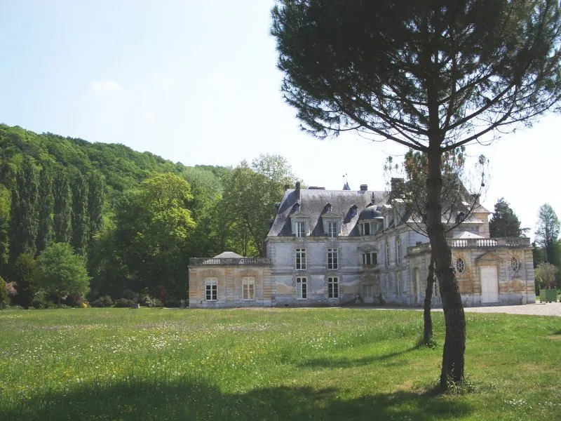
Le domaine est situé en fond de vallée, entre l'Eure et l'Iton. Remplaçant un château fort rasé en 1378, le château d'Acquigny a été construit entre 1557 et 1572 et devait dès l'origine posséder des jardins importants. Le château et le parc ont été progressivement agrandis et transformés au 17e siècle, et surtout à partir de 1745 pour le Président d'Acquigny, président à mortier du Parlement de Rouen, par l'architecte Charles Thibault. L'ensemble comporte des communs, au nord et à l'ouest d'une vaste cour, une église, prolongée au sud-ouest par une orangerie, un vaste parc au dessin régulier, parcouru par un réseau de canaux se recoupant entre eux et alimentant deux miroirs d'eau et un grand canal. A la fin de sa vie, le président d'Acquigny s'est fait construire un logement secondaire accolé au chevet de l'église, connu sous le nom de Petit Château. L'ensemble des constructions de la seconde moitié du 18e siècle est homogène, notamment en raison d'un emploi quasi exclusif de brique orangée. Le parc a été mis au goût du jour postérieurement à 1823 (création d'une rivière artificielle, construction de cascades, ponts de rochers, introduction d'essences nouvelles, etc.). Entre 1845 et 1860, les douves ont été supprimées et le cimetière a été déplacé à son emplacement actuel.
Map and restricted areas
Open in the main mapRestricted zones
| Zone | Category | Limits | Conditions |
|---|---|---|---|
| Tma Evreux |
Région de contrôle terminal | 457 m above sea level → 2297 m above sea level · 762 m above sea level → 2297 m above sea level | Drone flights inside this zone are forbidden without the prior agreement of air traffic control |
| ZRT ÉVREUX NORD (IHEDN uniquement) | ZRT | From about 2,900 m to about 3,800 m above sea level | SUP AIP 053/26 · Du jeudi 16 avril 2026 au mercredi 12 avril 2028 |
Nearby aerodromes
Open aerodromes within 25 km of the spot, heliports included, with their distance and direction from the spot. Near an aerodrome, drone flying is prohibited or height-limited: check the UAS zones map.
| Aerodrome | Type | Distance | Elevation |
|---|---|---|---|
| Base ULM de Val de Reuil | Aerodrome | 13 km N | 10 m |
| Aérodrome privé de Cesseville Ferme des Moulins | Aerodrome | 14 km W | 148 m |
| Évreux-Fauville (BA 105) Air Base | Airport | 16 km S | 141 m |
| Rouen Airport | Airport | 24 km N | 156 m |
Aviation weather (METAR and TAF)
LFOE – Évreux-Fauville (BA 105) Air Base VFR
METAR
METAR LFOE 171330Z AUTO 22016KT 9999 FEW030 BKN200 15/10 Q0990 TEMPO 27030G50KT 2000 SHRA BKN020CB
- Wind
- 220°, 30 km/h
- Visibility
- 10 km or more
- Clouds
- Few (1-2/8) at 3,000 ft (910 m) ; Broken (5-7/8) at 20,000 ft (6100 m)
- Temperature
- 15 °C, dew point 10 °C
- QNH
- 990 hPa
- Flight category
- VFR: ceiling > 3,000 ft and visibility > 5 mi
TAF
TAF LFOE 170800Z 1709/1809 21020G30KT 9999 BKN025 TEMPO 1715/1719 25025G45KT 2000 SHRA BKN025TCU PROB40 TEMPO 1715/1719 27030G50KT -TSRAGS BKN020CB
| Period (local time) | Change | Wind | Visibility | Weather | Clouds |
|---|---|---|---|---|---|
| 17/11 10:00 → 18/11 10:00 | Initial conditions | 210°, 37 km/h, gusts 56 km/h | 10 km or more | Broken (5-7/8) at 2,500 ft (760 m) | |
| 17/11 16:00 → 17/11 20:00 | Temporarily | 250°, 46 km/h, gusts 83 km/h | 2.0 km | Showers of rain | Broken (5-7/8) at 2,500 ft (760 m) (towering cumulus) |
| 17/11 16:00 → 17/11 20:00 | Temporarily, probability 40% | 270°, 56 km/h, gusts 93 km/h | Thunderstorm rain light ; thunderstorm small hail light | Broken (5-7/8) at 2,000 ft (610 m) (cumulonimbus) |
Weather and Kp index
| Day | Weather | Temp. min. / max. | Wind | Rain | Max Kp |
|---|---|---|---|---|---|
| Tue 17 Nov | Rain | 10° / 12° | 32 km/h SW | 3.4 mm | 5 |
| Wed 18 Nov | Showers | 10° / 14° | 31 km/h W | 3.5 mm | 5 |
| Thu 19 Nov | Partly cloudy | 8° / 13° | 34 km/h SW | 4.8 mm | 3 |
| Fri 20 Nov | Light rain | 9° / 13° | 27 km/h W | 3.3 mm | 3 |
| Sat 21 Nov | Partly cloudy | 7° / 11° | 24 km/h W | 0.8 mm | – |
| Sun 22 Nov | Cloudy | 6° / 8° | 14 km/h E | 9.2 mm | – |
| Mon 23 Nov | Clear sky | 7° / 11° | 16 km/h W | 0.8 mm | – |
Hour by hour: Tuesday 17 November
| Time | Weather | Temp. | Wind | Rain | Clouds | Kp |
|---|---|---|---|---|---|---|
| 15:00 | Rain | 12° | 26 km/h SW | 1.0 mm | 94 % | 4 |
| 16:00 | Rain | 12° | 29 km/h SW | 0.6 mm | 100 % | 4 |
| 17:00 | Rain | 12° | 32 km/h SW | 0.7 mm | 100 % | 4 |
| 18:00 | Heavy rain | 11° | 28 km/h SW | 1.0 mm | 99 % | 4 |
| 19:00 | Cloudy | 11° | 30 km/h SW | – | 100 % | 5 |
| 20:00 | Showers | 11° | 28 km/h SW | 0.1 mm | 72 % | 5 |
| 21:00 | Fair | 11° | 27 km/h SW | – | 32 % | 5 |
| 22:00 | Fair | 10° | 25 km/h SW | – | 30 % | 5 |
Hour by hour: Wednesday 18 November
| Time | Weather | Temp. | Wind | Rain | Clouds | Kp |
|---|---|---|---|---|---|---|
| 06:00 | Partly cloudy | 10° | 24 km/h SW | – | 69 % | 4 |
| 07:00 | Partly cloudy | 10° | 24 km/h SW | – | 78 % | 4 |
| 08:00 | Partly cloudy | 10° | 24 km/h SW | – | 80 % | 4 |
| 09:00 | Partly cloudy | 10° | 24 km/h SW | – | 68 % | 4 |
| 10:00 | Partly cloudy | 11° | 23 km/h SW | – | 54 % | 4 |
| 11:00 | Partly cloudy | 12° | 26 km/h SW | – | 53 % | 4 |
| 12:00 | Showers | 13° | 29 km/h SW | 0.1 mm | 34 % | 4 |
| 13:00 | Showers | 13° | 31 km/h W | 0.2 mm | 36 % | 3 |
| 14:00 | Fair | 13° | 28 km/h W | – | 25 % | 3 |
| 15:00 | Clear sky | 14° | 26 km/h W | – | 8 % | 3 |
| 16:00 | Fair | 13° | 23 km/h SW | – | 17 % | 3 |
| 17:00 | Partly cloudy | 12° | 21 km/h SW | – | 72 % | 3 |
| 18:00 | Cloudy | 11° | 17 km/h SW | – | 87 % | 3 |
| 19:00 | Cloudy | 11° | 18 km/h SW | – | 89 % | 2 |
| 20:00 | Heavy rain | 11° | 18 km/h S | 1.2 mm | 99 % | 2 |
| 21:00 | Heavy rain | 10° | 20 km/h S | 1.7 mm | 100 % | 2 |
| 22:00 | Light rain | 10° | 21 km/h S | 0.3 mm | 94 % | 2 |
Sunrise and sunset
| Day | Dawn | Sunrise | Golden hour | Sunset | Dusk | Day length |
|---|---|---|---|---|---|---|
| Tue 17 Nov | 07:33 | 08:08 | 08:08–08:59 · 16:22–17:12 | 17:12 | 17:47 | 9 h 03 |
| Wed 18 Nov | 07:35 | 08:10 | 08:10–09:01 · 16:20–17:11 | 17:11 | 17:46 | 9 h 00 |
| Thu 19 Nov | 07:36 | 08:11 | 08:11–09:02 · 16:19–17:10 | 17:10 | 17:45 | 8 h 58 |
| Fri 20 Nov | 07:38 | 08:13 | 08:13–09:04 · 16:18–17:09 | 17:09 | 17:44 | 8 h 55 |
| Sat 21 Nov | 07:39 | 08:15 | 08:15–09:06 · 16:16–17:08 | 17:08 | 17:43 | 8 h 53 |
| Sun 22 Nov | 07:41 | 08:16 | 08:16–09:08 · 16:15–17:07 | 17:07 | 17:42 | 8 h 50 |
| Mon 23 Nov | 07:42 | 08:17 | 08:17–09:09 · 16:14–17:06 | 17:06 | 17:41 | 8 h 48 |

Reviews (0)
Log in to review this spot. Log in · Create a free account
No reviews yet. Share yours!