

Castle
No reviews yet
Have you flown here? Share your experience with other pilots.
+ Write the first reviewHistory
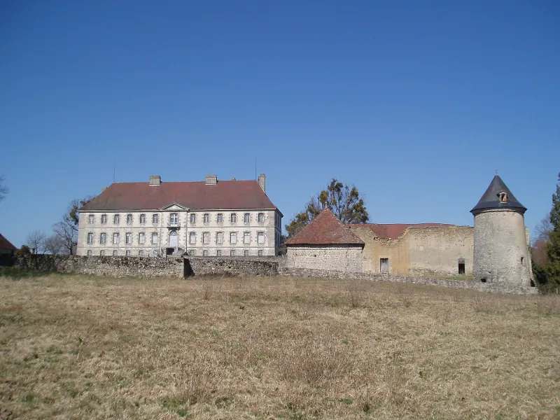
Demeure bâtie au 18e siècle à l'emplacement d'un château plus ancien. En 1439, le dauphin, futur Louis XI y logea. La chapelle Saint-Hubert est mentionnée dès 1518. Le château est relié à la prairie par une allée d'arbres ouvrant au sud par un portail aux piedroits avec deux courbes dégageant un pilastre sur le devant, et couronnés d'un entablement à la corniche saillante. A droite se dresse le pavillon du gardien. Une cour d'honneur précède le château. De part et d'autre de cette cour s'élèvent deux pavillons carrés au-delà desquels s'élève une tour. Entre ces pavillons et le château, de chaque côté de la cour, se trouvent les communs. Au fond de la cour, un escalier accède à la terrasse sur laquelle se trouve le corps de logis. En contre-bas de la terrasse se trouvent les ruines de l'orangerie, sur cave voûtée. A l'intérieur, le château conserve en sous-sol des pièces voûtées en berceau dont l'une possède une cheminée de la fin de l'époque gothique, reste du précédent édifice. Décors de stucs et cheminées du 18e siècle. Le salon à l'est conserve son ancien parquet à feuilles et un plafond en caisson avec décor de stuc.
Map and restricted areas
Open in the main mapRestricted zones
Nearby aerodromes
Open aerodromes within 25 km of the spot, heliports included, with their distance and direction from the spot. Near an aerodrome, drone flying is prohibited or height-limited: check the UAS zones map.
| Aerodrome | Type | Distance | Elevation |
|---|---|---|---|
| Centre Médical Heliport | Heliport | 2.7 km W | 470 m |
| Aérodrome de Guéret Saint-Laurent | Aerodrome | 4.8 km NE | 368 m |
| Centre Hospitalier Heliport | Heliport | 24 km SW | 450 m |
Aviation weather (METAR and TAF)
No METAR station within 50 km.
Weather and Kp index
Sunrise and sunset
| Day | Dawn | Sunrise | Golden hour | Sunset | Dusk | Day length |
|---|---|---|---|---|---|---|
| Tue 17 Nov | 07:23 | 07:56 | 07:56–08:42 · 16:32–17:19 | 17:19 | 17:51 | 9 h 22 |
| Wed 18 Nov | 07:25 | 07:57 | 07:57–08:44 · 16:31–17:18 | 17:18 | 17:50 | 9 h 20 |
| Thu 19 Nov | 07:26 | 07:59 | 07:59–08:45 · 16:30–17:17 | 17:17 | 17:49 | 9 h 17 |
| Fri 20 Nov | 07:27 | 08:00 | 08:00–08:47 · 16:29–17:16 | 17:16 | 17:49 | 9 h 15 |
| Sat 21 Nov | 07:28 | 08:01 | 08:01–08:49 · 16:28–17:15 | 17:15 | 17:48 | 9 h 13 |
| Sun 22 Nov | 07:30 | 08:03 | 08:03–08:50 · 16:27–17:14 | 17:14 | 17:47 | 9 h 11 |
| Mon 23 Nov | 07:31 | 08:04 | 08:04–08:52 · 16:26–17:13 | 17:13 | 17:46 | 9 h 09 |
Reviews (0)
Log in to review this spot. Log in · Create a free account
No reviews yet. Share yours!