

Martainville Castle
No reviews yet
Have you flown here? Share your experience with other pilots.
+ Write the first reviewHistory
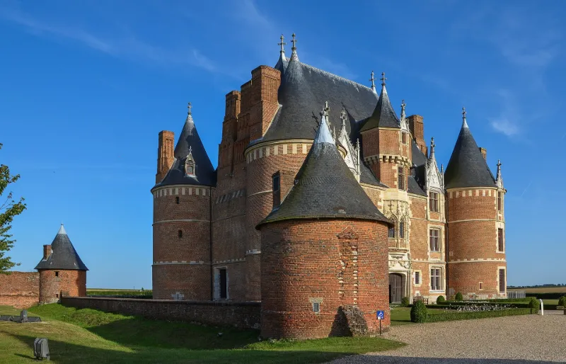
Le château de Martainville a été édifié à partir de 1485 environ par le négociant rouennais Le Pelletier, sur les vestiges d'un ancien château-fort, tandis que le domaine était constitué par échange de terrains. Ce domaine est enclos de murs de brique et ponctué de tourelles, dont le tracé est encore lisible et dont certaines portions sont conservées en élévation. Le château est un quadrilatère cantonné de quatre grosses tours d'angle, et muni sur la façade arrière d'une tourelle d'escalier. Vers la fin du 16e siècle, il a été doté d'une enceinte rectangulaire ponctuée de quatre tourelles, et un nouveau fossé non maçonné a été creusé à l'extérieur. Des jardins d'agrément ont été créés dans cet espace clos aux 17e et 18e siècles. Il en subsiste des vestiges, et ils sont connus par une série de plans et miniatures du 18e siècle. Acquis par l'Etat en 1906, le château a été cédé au département en 2002. Il constitue l'une des manifestations les plus significatives de l'architecture civile de la fin du gothique.
Map and restricted areas
Open in the main mapRestricted zones
| Zone | Category | Limits | Conditions |
|---|---|---|---|
| Ctr Rouen |
Zone de contrôle civile | 50 m above ground level → 610 m above sea level | Flights above 50 metres are forbidden without the prior agreement of air traffic control |
| Paris 7 | Zone réglementée | 1529 m above sea level → 2907 m above sea level | Vols interdits sauf lorsque the official document of the zone l'autorise explicitement ou avec l'accord du gestionnaire de la zone lorsqu'il est désigné par the official document of the zone |
| Paris 9 | Zone réglementée | 2138 m above sea level → 3821 m above sea level | Vols interdits sauf lorsque the official document of the zone l'autorise explicitement ou avec l'accord du gestionnaire de la zone lorsqu'il est désigné par the official document of the zone |
Nearby aerodromes
Open aerodromes within 25 km of the spot, heliports included, with their distance and direction from the spot. Near an aerodrome, drone flying is prohibited or height-limited: check the UAS zones map.
| Aerodrome | Type | Distance | Elevation |
|---|---|---|---|
| Rouen Airport | Airport | 12 km SW | 156 m |
| Centre Hospitalier Heliport | Heliport | 13 km W | 44 m |
| Base ULM de Val de Reuil | Aerodrome | 20 km S | 10 m |
| Casino Heliport | Heliport | 23 km NE | 150 m |
Aviation weather (METAR and TAF)
LFOP – Rouen Airport VFR
METAR
METAR LFOP 171330Z AUTO 22020KT 9999 FEW029 BKN033 BKN039 14/09 Q0989 TEMPO VRB25G40KT 2000 -TSRAGS OVC012CB
- Wind
- 220°, 37 km/h
- Visibility
- 10 km or more
- Clouds
- Few (1-2/8) at 2,900 ft (880 m) ; Broken (5-7/8) at 3,300 ft (1010 m) ; Broken (5-7/8) at 3,900 ft (1190 m)
- Temperature
- 14 °C, dew point 9 °C
- QNH
- 989 hPa
- Flight category
- VFR: ceiling > 3,000 ft and visibility > 5 mi
TAF
TAF LFOP 171100Z 1712/1721 25020G30KT 9999 BKN020 TEMPO 1713/1721 4000 SHRA BKN020TCU PROB30 TEMPO 1714/1720 VRB25G40KT 2000 -TSRAGS OVC012CB
| Period (local time) | Change | Wind | Visibility | Weather | Clouds |
|---|---|---|---|---|---|
| 17/11 13:00 → 17/11 22:00 | Initial conditions | 250°, 37 km/h, gusts 56 km/h | 10 km or more | Broken (5-7/8) at 2,000 ft (610 m) | |
| 17/11 14:00 → 17/11 22:00 | Temporarily | 4.0 km | Showers of rain | Broken (5-7/8) at 2,000 ft (610 m) (towering cumulus) | |
| 17/11 15:00 → 17/11 21:00 | Temporarily, probability 30% | Variable, 46 km/h, gusts 74 km/h | 2.0 km | Thunderstorm rain light ; thunderstorm small hail light | Overcast (8/8) at 1,200 ft (370 m) (cumulonimbus) |
Weather and Kp index
| Day | Weather | Temp. min. / max. | Wind | Rain | Max Kp |
|---|---|---|---|---|---|
| Tue 17 Nov | Heavy rain | 10° / 11° | 36 km/h SW | 5.4 mm | 5 |
| Wed 18 Nov | Showers | 9° / 12° | 31 km/h SW | 7.7 mm | 5 |
| Thu 19 Nov | Light rain | 8° / 11° | 31 km/h SW | 5.4 mm | 3 |
| Fri 20 Nov | Light rain | 8° / 11° | 27 km/h SW | 5.0 mm | 3 |
| Sat 21 Nov | Fair | 6° / 9° | 22 km/h W | 0.6 mm | – |
| Sun 22 Nov | Cloudy | 5° / 7° | 19 km/h SE | 8.3 mm | – |
| Mon 23 Nov | Partly cloudy | 6° / 10° | 17 km/h W | 2.0 mm | – |
Hour by hour: Tuesday 17 November
| Time | Weather | Temp. | Wind | Rain | Clouds | Kp |
|---|---|---|---|---|---|---|
| 15:00 | Heavy rain | 11° | 31 km/h SW | 1.9 mm | 100 % | 4 |
| 16:00 | Rain | 11° | 27 km/h SW | 0.8 mm | 100 % | 4 |
| 17:00 | Rain | 11° | 34 km/h SW | 0.9 mm | 100 % | 4 |
| 18:00 | Rain | 10° | 36 km/h SW | 0.8 mm | 100 % | 4 |
| 19:00 | Showers | 10° | 31 km/h SW | 0.4 mm | 82 % | 5 |
| 20:00 | Light rain | 10° | 28 km/h SW | 0.3 mm | 100 % | 5 |
| 21:00 | Light rain | 10° | 29 km/h SW | 0.1 mm | 98 % | 5 |
| 22:00 | Light rain | 10° | 29 km/h SW | 0.1 mm | 100 % | 5 |
Hour by hour: Wednesday 18 November
| Time | Weather | Temp. | Wind | Rain | Clouds | Kp |
|---|---|---|---|---|---|---|
| 06:00 | Cloudy | 9° | 26 km/h SW | – | 93 % | 4 |
| 07:00 | Cloudy | 9° | 25 km/h SW | – | 97 % | 4 |
| 08:00 | Light rain | 9° | 25 km/h SW | 0.2 mm | 97 % | 4 |
| 09:00 | Cloudy | 9° | 26 km/h SW | – | 100 % | 4 |
| 10:00 | Cloudy | 10° | 25 km/h SW | – | 91 % | 4 |
| 11:00 | Showers | 11° | 28 km/h SW | 0.2 mm | 77 % | 4 |
| 12:00 | Showers | 11° | 31 km/h SW | 0.2 mm | 68 % | 4 |
| 13:00 | Showers | 12° | 30 km/h W | 0.2 mm | 76 % | 3 |
| 14:00 | Showers | 12° | 28 km/h W | 0.3 mm | 62 % | 3 |
| 15:00 | Fair | 12° | 27 km/h W | – | 34 % | 3 |
| 16:00 | Fair | 12° | 24 km/h SW | – | 20 % | 3 |
| 17:00 | Showers | 11° | 22 km/h SW | 0.2 mm | 50 % | 3 |
| 18:00 | Partly cloudy | 10° | 17 km/h SW | – | 81 % | 3 |
| 19:00 | Cloudy | 10° | 17 km/h SW | – | 98 % | 2 |
| 20:00 | Light rain | 9° | 17 km/h S | 0.2 mm | 98 % | 2 |
| 21:00 | Heavy rain | 9° | 22 km/h S | 1.9 mm | 100 % | 2 |
| 22:00 | Rain | 9° | 23 km/h S | 0.7 mm | 100 % | 2 |
Sunrise and sunset
| Day | Dawn | Sunrise | Golden hour | Sunset | Dusk | Day length |
|---|---|---|---|---|---|---|
| Tue 17 Nov | 07:34 | 08:09 | 08:09–09:00 · 16:20–17:11 | 17:11 | 17:46 | 9 h 01 |
| Wed 18 Nov | 07:35 | 08:11 | 08:11–09:02 · 16:18–17:09 | 17:09 | 17:45 | 8 h 58 |
| Thu 19 Nov | 07:37 | 08:12 | 08:12–09:03 · 16:17–17:08 | 17:08 | 17:44 | 8 h 56 |
| Fri 20 Nov | 07:38 | 08:14 | 08:14–09:05 · 16:16–17:07 | 17:07 | 17:43 | 8 h 53 |
| Sat 21 Nov | 07:39 | 08:15 | 08:15–09:07 · 16:14–17:06 | 17:06 | 17:42 | 8 h 51 |
| Sun 22 Nov | 07:41 | 08:17 | 08:17–09:09 · 16:13–17:05 | 17:05 | 17:41 | 8 h 48 |
| Mon 23 Nov | 07:42 | 08:18 | 08:18–09:10 · 16:12–17:04 | 17:04 | 17:40 | 8 h 46 |

Reviews (0)
Log in to review this spot. Log in · Create a free account
No reviews yet. Share yours!