

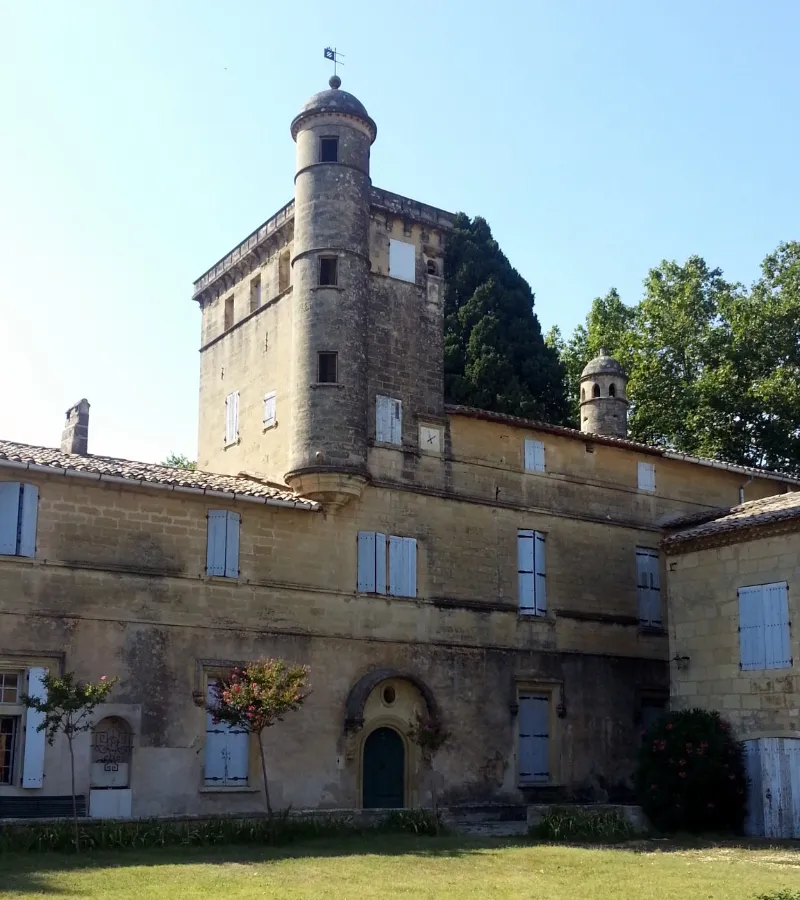
Teillan Castle
No reviews yet
Have you flown here? Share your experience with other pilots.
+ Write the first reviewHistory
Au 10e siècle, Teillan appartenait aux vicomtes Aton, comtes de Carcassonne et de Razes. Jusqu'à la fin du 16e siècle, Teillan devint une dépendance de l'abbaye de Psalmody, qui fut acquis par Philippe de Bornier, conseiller du roi. Lieu de culte reconnu par l'Eglise réformée lors de l'Edit de Nantes. Resté sans modifications depuis le début du 17e siècle, le château subit quelques dommages en 1793 (destruction d'une tourelle, reconstruite en 1873, et de la porte fortifiée Est). Au cours du 19e siècle, aménagement des communs, des façades et de certains couronnements. Le château déploie ses bâtiments autour d'une cour intérieure dont l'accès se fait par un passage voûté situé sous les communs (aile est). Ces communs occupent les ailes est, sud et nord et ont été transformés de 1820 à 1875. Le corps de bâtiment principal est voûté au rez-de-chaussée. Ces voûtes dateraient du 15e siècle. Le premier étage côté nord, construit à la fin du 16e siècle, a té remanié en 1820 ; le côté sud a été remanié et reconstruit de 1820 à 1876. Le pigeonnier à voûte en mitre d'évêque a été réalisé en pierre de taille vers 1600 avec une échelle tournante intérieure en bois. La salle voûtée du rez-de-chaussée servait de prison pour la seigneurie. Sous la cuve qui occupe cette pièce se trouve le passage d'un souterrain joignant le château à des dépendances dans la propriété de Pravielle. Selon la tradition orale, il rejoindrait même l'abbaye de Psalmodie. Le puits à roue ou noria, relié au Vidourles par un aqueduc souterrain, date de 1609. Ses superstructures ont été remaniées sous la Restauration de manière à constituer un vaste bassin alimenté par une vasque de déversement des godets en pierre à la place de l'ancienne auge en bois. La mécanique a été constamment entretenue jusque vers 1920, car il arrosait le jardin potager. La porte du début du 17e siècle, percée dans l'aile nord, était l'ancienne entrée d'honneur du château. Les piédroits et l'arc de la porte sont ornés de bossages composés alternativement de tables rectangulaires et de pointes de diamant. Elle est coiffée d'un fronton triangulaire rompu entre les branches duquel se trouve une table de pierre.
Map and restricted areas
Open in the main mapRestricted zones
| Zone | Category | Limits | Conditions |
|---|---|---|---|
| Rhone | Zone réglementée | 762 m above sea level → 6259 m above sea level | Vols interdits sauf lorsque the official document of the zone l'autorise explicitement ou avec l'accord du gestionnaire de la zone lorsqu'il est désigné par the official document of the zone |
| Istres | Zone réglementée | 5491 m above sea level → 30766 m above sea level | Vols interdits sauf lorsque the official document of the zone l'autorise explicitement ou avec l'accord du gestionnaire de la zone lorsqu'il est désigné par the official document of the zone |
| Istres | Zone réglementée | 5491 m above sea level → 30766 m above sea level | Vols interdits sauf lorsque the official document of the zone l'autorise explicitement ou avec l'accord du gestionnaire de la zone lorsqu'il est désigné par the official document of the zone |
| Zrt 108 E4 | ZRT | From about 2,300 m to about 4,400 m above sea level | SUP AIP 232/24 · Du 6 janvier 2025 au 14 avril 2027 |
Nearby aerodromes
Open aerodromes within 25 km of the spot, heliports included, with their distance and direction from the spot. Near an aerodrome, drone flying is prohibited or height-limited: check the UAS zones map.
| Aerodrome | Type | Distance | Elevation |
|---|---|---|---|
| Aérodrome de Montpellier - Candillargues | Aerodrome | 11 km SW | 2 m |
| Montpellier-Méditerranée Airport | Airport | 21 km SW | 5 m |
| Nîmes-Arles-Camargue Airport | Airport | 21 km NE | 94 m |
Aviation weather (METAR and TAF)
LFMT – Montpellier-Méditerranée Airport VFR
METAR
METAR LFMT 171330Z AUTO 22006KT 170V260 9999 BKN100/// OVC130/// ///TCU 15/13 Q1003 TEMPO
- Wind
- 220°, 11 km/h
- Visibility
- 10 km or more
- Clouds
- Broken (5-7/8) at 10,000 ft (3050 m) ; Overcast (8/8) at 13,000 ft (3960 m)
- Temperature
- 15 °C, dew point 13 °C
- QNH
- 1003 hPa
- Flight category
- VFR: ceiling > 3,000 ft and visibility > 5 mi
TAF
TAF LFMT 170800Z 1709/1809 01008KT 9999 BKN016 BECMG 1710/1712 CAVOK TEMPO 1712/1718 -SHRA FEW050TCU BECMG 1713/1715 21010KT
| Period (local time) | Change | Wind | Visibility | Weather | Clouds |
|---|---|---|---|---|---|
| 17/11 10:00 → 17/11 11:00 | Initial conditions | 010°, 15 km/h | 10 km or more | Broken (5-7/8) at 1,600 ft (490 m) | |
| 17/11 11:00 → 17/11 14:00 | Becoming | 010°, 15 km/h | 10 km or more | No significant weather | No significant cloud |
| 17/11 13:00 → 17/11 19:00 | Temporarily | Showers of rain light | Few (1-2/8) at 5,000 ft (1520 m) (towering cumulus) | ||
| 17/11 14:00 → 18/11 10:00 | Becoming | 210°, 19 km/h | 10 km or more | No significant weather | No significant cloud |
Weather and Kp index
| Day | Weather | Temp. min. / max. | Wind | Rain | Max Kp |
|---|---|---|---|---|---|
| Tue 17 Nov | Cloudy | 13° / 16° | 18 km/h SW | 3.1 mm | 5 |
| Wed 18 Nov | Partly cloudy | 12° / 18° | 21 km/h W | 0.3 mm | 5 |
| Thu 19 Nov | Fair | 12° / 16° | 31 km/h W | 8.1 mm | 3 |
| Fri 20 Nov | Fair | 11° / 15° | 20 km/h W | – | 3 |
| Sat 21 Nov | Partly cloudy | 9° / 16° | 11 km/h W | 0.1 mm | – |
| Sun 22 Nov | Clear sky | 12° / 16° | 21 km/h W | 1.6 mm | – |
| Mon 23 Nov | Partly cloudy | 9° / 16° | 18 km/h W | – | – |
Hour by hour: Tuesday 17 November
| Time | Weather | Temp. | Wind | Rain | Clouds | Kp |
|---|---|---|---|---|---|---|
| 15:00 | Cloudy | 16° | 15 km/h SW | – | 100 % | 4 |
| 16:00 | Cloudy | 15° | 18 km/h SW | – | 100 % | 4 |
| 17:00 | Rain | 14° | 17 km/h SW | 0.9 mm | 88 % | 4 |
| 18:00 | Cloudy | 14° | 14 km/h SW | – | 98 % | 4 |
| 19:00 | Rain | 14° | 12 km/h SW | 0.5 mm | 96 % | 5 |
| 20:00 | Cloudy | 13° | 8 km/h SW | – | 91 % | 5 |
| 21:00 | Rain | 13° | 4 km/h E | 0.7 mm | 100 % | 5 |
| 22:00 | Rain | 13° | 9 km/h SE | 1.0 mm | 100 % | 5 |
Hour by hour: Wednesday 18 November
| Time | Weather | Temp. | Wind | Rain | Clouds | Kp |
|---|---|---|---|---|---|---|
| 06:00 | Cloudy | 13° | 17 km/h SW | – | 100 % | 4 |
| 07:00 | Cloudy | 14° | 20 km/h SW | – | 88 % | 4 |
| 08:00 | Partly cloudy | 14° | 20 km/h W | – | 60 % | 4 |
| 09:00 | Partly cloudy | 15° | 20 km/h W | – | 74 % | 4 |
| 10:00 | Partly cloudy | 16° | 18 km/h W | – | 65 % | 4 |
| 11:00 | Showers | 17° | 21 km/h W | 0.3 mm | 66 % | 4 |
| 12:00 | Partly cloudy | 17° | 17 km/h W | – | 77 % | 4 |
| 13:00 | Partly cloudy | 18° | 19 km/h W | – | 41 % | 3 |
| 14:00 | Clear sky | 18° | 19 km/h W | – | 10 % | 3 |
| 15:00 | Clear sky | 18° | 18 km/h W | – | 1 % | 3 |
| 16:00 | Clear sky | 17° | 15 km/h W | – | 3 % | 3 |
| 17:00 | Fair | 15° | 14 km/h W | – | 21 % | 3 |
| 18:00 | Partly cloudy | 14° | 12 km/h W | – | 58 % | 3 |
| 19:00 | Partly cloudy | 13° | 10 km/h SW | – | 77 % | 2 |
| 20:00 | Partly cloudy | 12° | 11 km/h SW | – | 90 % | 2 |
| 21:00 | Partly cloudy | 12° | 10 km/h SW | – | 65 % | 2 |
| 22:00 | Partly cloudy | 12° | 9 km/h S | – | 98 % | 2 |
Sunrise and sunset
| Day | Dawn | Sunrise | Golden hour | Sunset | Dusk | Day length |
|---|---|---|---|---|---|---|
| Tue 17 Nov | 07:09 | 07:40 | 07:40–08:24 · 16:33–17:17 | 17:17 | 17:48 | 9 h 36 |
| Wed 18 Nov | 07:10 | 07:41 | 07:41–08:25 · 16:32–17:16 | 17:16 | 17:47 | 9 h 34 |
| Thu 19 Nov | 07:11 | 07:42 | 07:42–08:26 · 16:31–17:15 | 17:15 | 17:46 | 9 h 32 |
| Fri 20 Nov | 07:12 | 07:44 | 07:44–08:28 · 16:30–17:14 | 17:14 | 17:45 | 9 h 30 |
| Sat 21 Nov | 07:14 | 07:45 | 07:45–08:29 · 16:29–17:13 | 17:13 | 17:45 | 9 h 28 |
| Sun 22 Nov | 07:15 | 07:46 | 07:46–08:31 · 16:28–17:13 | 17:13 | 17:44 | 9 h 26 |
| Mon 23 Nov | 07:16 | 07:47 | 07:47–08:32 · 16:27–17:12 | 17:12 | 17:43 | 9 h 24 |

Reviews (0)
Log in to review this spot. Log in · Create a free account
No reviews yet. Share yours!