

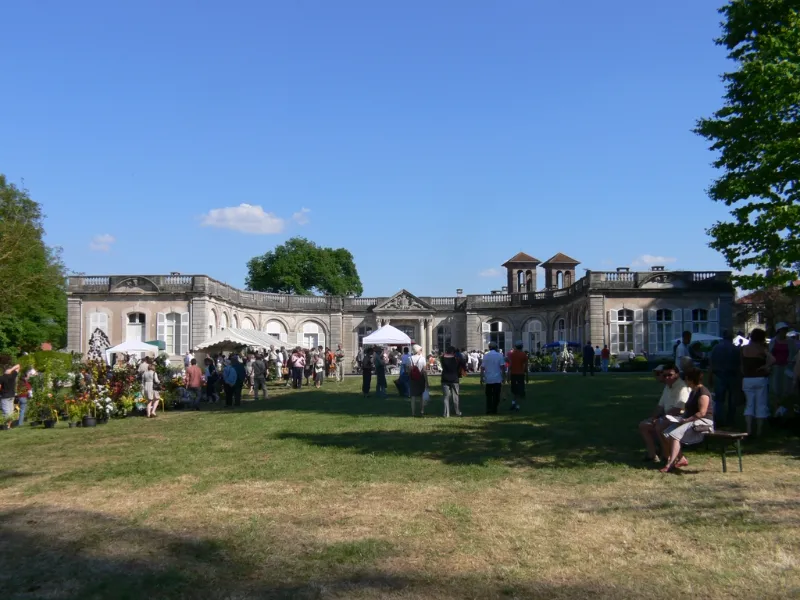
Castle Estate
No reviews yet
Have you flown here? Share your experience with other pilots.
+ Write the first reviewHistory
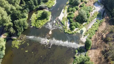
L'histoire du domaine s'échelonne sur trois siècles, du premier quart du 17e siècle aux années 1925. Le domaine comprend le château (construit vers 1620-1630, restructuré au début du 20e siècle après un incendie en 1914) , la chapelle castrale du 17e siècle (remaniée aux 19e et 20e siècles) et les bâtiments de dépendances, dont un théâtre (de la deuxième moitié du 19e siècle). Le parc (de la première moitié du 19e siècle) comprend un pavillon de briques dit pavillon rouge et un nymphée, tous deux du début du 17e siècle. Le domaine appartient à la même famille depuis 1737. Chapelle castrale attestée dès 1050, agrandie au 15e siècle alors qu'elle servait d'église paroissiale. L'édifice subit un nouvel agrandissement au début du 17e siècle. Christine Claude du Châtelet en fait don aux Carmes en 1618. La chapelle et le couvent sont vendus comme biens nationaux pendant la Révolution. L'édifice, qui abritait les sépultures des seigneurs de Gerbeviller, retrouve son rôle de chapelle castrale et subit des restaurations au cours du 19e siècle. De 1920 à 1923, restauration des deux tours de l'entrée et de la sacristie suite au bombardement du 24 août 1914. Chapelle de plan basilical avec deux tours en façade. Le portail est précédé d'un porche à entablement porté par quatre colonnes d'ordre toscan. La sacristie, de plan rectangulaire, est accolée au sud-est.
Map and restricted areas
Open in the main mapRestricted zones
| Zone | Category | Limits | Conditions |
|---|---|---|---|
| Tma Nancy |
Région de contrôle terminal | 762 m above sea level → 2602 m above sea level · 762 m above sea level → 2602 m above sea level · 1158 m above sea level → 2297 m above sea level · 1224 m above sea level → 6259 m above sea level · 1524 m above sea level → 2602 m above sea level · 3053 m above sea level → 6259 m above sea level | Drone flights inside this zone are forbidden without the prior agreement of air traffic control |
| Zrt Treveri | ZRT | From about 14,950 m to about 16,750 m above sea level | SUP AIP 233/24 · Du 16 janvier 2025 au 13 janvier 2027 |
Nearby aerodromes
Open aerodromes within 25 km of the spot, heliports included, with their distance and direction from the spot. Near an aerodrome, drone flying is prohibited or height-limited: check the UAS zones map.
| Aerodrome | Type | Distance | Elevation |
|---|---|---|---|
| Mont sur Meurthe | Aerodrome | 7.0 km NW | 241 m |
| Lunéville-Croismare Airfield | Aerodrome | 11 km N | 241 m |
| Nancy Azelot Airfield | Aerodrome | 22 km NW | 293 m |
Aviation weather (METAR and TAF)
LFSN – Nancy-Essey Airport VFR
METAR
METAR LFSN 171330Z AUTO 24018G32KT 210V270 9999 BKN039 OVC047 OVC056 16/10 Q0993
- Wind
- 240°, 33 km/h, gusts 59 km/h
- Visibility
- 10 km or more
- Clouds
- Broken (5-7/8) at 3,900 ft (1190 m) ; Overcast (8/8) at 4,700 ft (1430 m) ; Overcast (8/8) at 5,600 ft (1710 m)
- Temperature
- 16 °C, dew point 10 °C
- QNH
- 993 hPa
- Flight category
- VFR: ceiling > 3,000 ft and visibility > 5 mi
TAF
Weather and Kp index
| Day | Weather | Temp. min. / max. | Wind | Rain | Max Kp |
|---|---|---|---|---|---|
| Tue 17 Nov | Partly cloudy | 10° / 14° | 34 km/h SW | 5.2 mm | 5 |
| Wed 18 Nov | Showers | 8° / 11° | 37 km/h SW | 5.5 mm | 5 |
| Thu 19 Nov | Showers | 8° / 11° | 32 km/h SW | 14 mm | 3 |
| Fri 20 Nov | Light rain | 8° / 9° | 31 km/h SW | 11 mm | 3 |
| Sat 21 Nov | Partly cloudy | 5° / 9° | 25 km/h W | 3.4 mm | – |
| Sun 22 Nov | Rain | 2° / 7° | 19 km/h SW | 6.7 mm | – |
| Mon 23 Nov | Cloudy | 6° / 8° | 21 km/h SW | 1.8 mm | – |
Hour by hour: Tuesday 17 November
| Time | Weather | Temp. | Wind | Rain | Clouds | Kp |
|---|---|---|---|---|---|---|
| 15:00 | Partly cloudy | 14° | 31 km/h SW | – | 46 % | 4 |
| 16:00 | Partly cloudy | 14° | 27 km/h SW | – | 84 % | 4 |
| 17:00 | Partly cloudy | 14° | 26 km/h SW | – | 69 % | 4 |
| 18:00 | Showers | 12° | 28 km/h SW | 0.2 mm | 66 % | 4 |
| 19:00 | Partly cloudy | 12° | 30 km/h SW | – | 49 % | 5 |
| 20:00 | Cloudy | 12° | 31 km/h SW | – | 100 % | 5 |
| 21:00 | Heavy rain | 12° | 32 km/h SW | 1.2 mm | 100 % | 5 |
| 22:00 | Heavy rain | 11° | 34 km/h SW | 2.3 mm | 100 % | 5 |
Hour by hour: Wednesday 18 November
| Time | Weather | Temp. | Wind | Rain | Clouds | Kp |
|---|---|---|---|---|---|---|
| 06:00 | Light rain | 9° | 26 km/h SW | 0.2 mm | 96 % | 4 |
| 07:00 | Light rain | 9° | 27 km/h SW | 0.2 mm | 87 % | 4 |
| 08:00 | Showers | 9° | 27 km/h SW | 0.3 mm | 81 % | 4 |
| 09:00 | Light rain | 10° | 28 km/h SW | 0.2 mm | 91 % | 4 |
| 10:00 | Showers | 10° | 28 km/h SW | 0.7 mm | 84 % | 4 |
| 11:00 | Showers | 10° | 30 km/h SW | 1.2 mm | 73 % | 4 |
| 12:00 | Showers | 11° | 32 km/h SW | 0.5 mm | 75 % | 4 |
| 13:00 | Showers | 11° | 32 km/h SW | 0.1 mm | 52 % | 3 |
| 14:00 | Showers | 11° | 32 km/h SW | 0.2 mm | 40 % | 3 |
| 15:00 | Partly cloudy | 11° | 29 km/h SW | – | 39 % | 3 |
| 16:00 | Showers | 11° | 27 km/h SW | 0.5 mm | 34 % | 3 |
| 17:00 | Partly cloudy | 10° | 24 km/h SW | – | 52 % | 3 |
| 18:00 | Fair | 9° | 22 km/h SW | – | 23 % | 3 |
| 19:00 | Clear sky | 9° | 22 km/h SW | – | 7 % | 2 |
| 20:00 | Partly cloudy | 9° | 21 km/h SW | – | 44 % | 2 |
| 21:00 | Partly cloudy | 9° | 22 km/h SW | – | 39 % | 2 |
| 22:00 | Partly cloudy | 9° | 23 km/h SW | – | 64 % | 2 |
Sunrise and sunset
| Day | Dawn | Sunrise | Golden hour | Sunset | Dusk | Day length |
|---|---|---|---|---|---|---|
| Tue 17 Nov | 07:11 | 07:45 | 07:45–08:34 · 16:04–16:53 | 16:53 | 17:27 | 9 h 08 |
| Wed 18 Nov | 07:12 | 07:46 | 07:46–08:36 · 16:02–16:52 | 16:52 | 17:26 | 9 h 05 |
| Thu 19 Nov | 07:13 | 07:48 | 07:48–08:38 · 16:01–16:51 | 16:51 | 17:25 | 9 h 02 |
| Fri 20 Nov | 07:15 | 07:49 | 07:49–08:40 · 16:00–16:50 | 16:50 | 17:24 | 9 h 00 |
| Sat 21 Nov | 07:16 | 07:51 | 07:51–08:41 · 15:58–16:49 | 16:49 | 17:24 | 8 h 57 |
| Sun 22 Nov | 07:17 | 07:52 | 07:52–08:43 · 15:57–16:48 | 16:48 | 17:23 | 8 h 55 |
| Mon 23 Nov | 07:19 | 07:54 | 07:54–08:45 · 15:56–16:47 | 16:47 | 17:22 | 8 h 53 |
Reviews (0)
Log in to review this spot. Log in · Create a free account
No reviews yet. Share yours!