

La Ramée Mill
No reviews yet
Have you flown here? Share your experience with other pilots.
+ Write the first reviewHistory
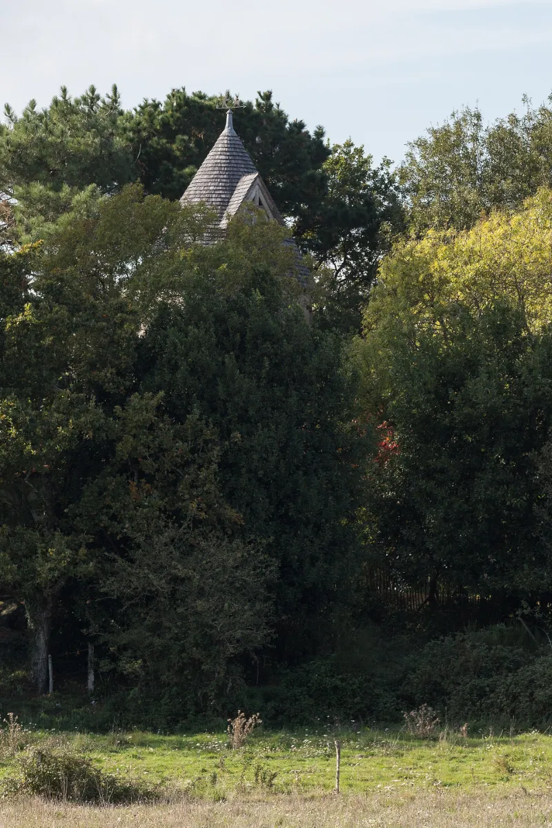
C'est probablement en 1567 que le moulin de la Ramée fut construit, comme le laisse penser cette date inscrite au dessus d'un blason martelé, sculpté sur le linteau de sa porte sud. Son activité cesse vers le milieu du 20e siècle. Sa toiture a été restaurée vers 1980.£La tour du moulin de la Ramée en moellons de granite, compte deux étages, et est couverte d'un toit conique en bardeaux de châtaignier. Ses ailes sont manquantes, la tête de l'arbre ayant été sectionnée. Tous ses mécanismes internes sont en place ; il possède une seule paire de meules. Par l'élargissement de sa base talutée formant une assise débordante, il se situe dans la tradition constructive des moulins du sillon de Bretagne et du pays de Guérande où cette particularité est fréquente aux 15e et 16e siècles.
Map and restricted areas
Open in the main mapRestricted zones
Nearby aerodromes
Open aerodromes within 25 km of the spot, heliports included, with their distance and direction from the spot. Near an aerodrome, drone flying is prohibited or height-limited: check the UAS zones map.
| Aerodrome | Type | Distance | Elevation |
|---|---|---|---|
| Base ULM de Frossay | Aerodrome | 8.8 km SE | 3 m |
| Saint-Nazaire-Montoir Airport | Airport | 14 km W | 4 m |
| Centre Hospitalier Heliport | Heliport | 19 km W | 19 m |
Aviation weather (METAR and TAF)
LFRZ – Saint-Nazaire-Montoir Airport MVFR
METAR
METAR LFRZ 171400Z AUTO 22020G31KT 9000 BKN020 OVC140 15/13 Q0993 BECMG 4500 -RA BKN020TCU
- Wind
- 220°, 37 km/h, gusts 57 km/h
- Visibility
- 9 km
- Clouds
- Broken (5-7/8) at 2,000 ft (610 m) ; Overcast (8/8) at 14,000 ft (4270 m)
- Temperature
- 15 °C, dew point 13 °C
- QNH
- 993 hPa
- Flight category
- MVFR: ceiling 1,000–3,000 ft or visibility 3–5 mi
TAF
TAF AMD LFRZ 171349Z 1713/1812 25015KT 9999 SCT017 BKN020 BKN150 BECMG 1713/1716 23020G30KT PROB30 TEMPO 1713/1715 4500 -SHRA SCT025TCU BECMG 1715/1717 4500 -RA BKN020TCU TEMPO 1716/1718 24030G50KT 2500 TSRAGS BKN014 BKN020CB BECMG 1717/1719 9999 NSW SCT014 BKN020 PROB40 TEMPO 1801/1806 4500 -SHRA SCT035CB PROB30 TEMPO 1803/1806 -TSRA
| Period (local time) | Change | Wind | Visibility | Weather | Clouds |
|---|---|---|---|---|---|
| 17/11 14:00 → 18/11 13:00 | Initial conditions | 250°, 28 km/h | 10 km or more | Scattered (3-4/8) at 1,700 ft (520 m) ; Broken (5-7/8) at 2,000 ft (610 m) ; Broken (5-7/8) at 15,000 ft (4570 m) | |
| 17/11 14:00 → 17/11 16:00 | Temporarily, probability 30% | 4.5 km | Showers of rain light | Scattered (3-4/8) at 2,500 ft (760 m) (towering cumulus) | |
| 17/11 14:00 → 17/11 16:00 | Becoming | 230°, 37 km/h, gusts 56 km/h | 10 km or more | Scattered (3-4/8) at 1,700 ft (520 m) ; Broken (5-7/8) at 2,000 ft (610 m) ; Broken (5-7/8) at 15,000 ft (4570 m) | |
| 17/11 16:00 → 17/11 18:00 | Becoming | 230°, 37 km/h, gusts 56 km/h | 4.5 km | Rain light | Broken (5-7/8) at 2,000 ft (610 m) (towering cumulus) |
| 17/11 17:00 → 17/11 19:00 | Temporarily | 240°, 56 km/h, gusts 93 km/h | 2.5 km | Thunderstorm rain ; thunderstorm small hail | Broken (5-7/8) at 1,400 ft (430 m) ; Broken (5-7/8) at 2,000 ft (610 m) (cumulonimbus) |
| 17/11 18:00 → 18/11 13:00 | Becoming | 230°, 37 km/h, gusts 56 km/h | 10 km or more | No significant weather | Scattered (3-4/8) at 1,400 ft (430 m) ; Broken (5-7/8) at 2,000 ft (610 m) |
| 18/11 02:00 → 18/11 07:00 | Temporarily, probability 40% | 4.5 km | Showers of rain light | Scattered (3-4/8) at 3,500 ft (1070 m) (cumulonimbus) | |
| 18/11 04:00 → 18/11 07:00 | Temporarily, probability 30% | Thunderstorm rain light |
Weather and Kp index
Sunrise and sunset
| Day | Dawn | Sunrise | Golden hour | Sunset | Dusk | Day length |
|---|---|---|---|---|---|---|
| Tue 17 Nov | 07:42 | 08:15 | 08:15–09:03 · 16:43–17:31 | 17:31 | 18:04 | 9 h 15 |
| Wed 18 Nov | 07:43 | 08:16 | 08:16–09:04 · 16:42–17:30 | 17:30 | 18:03 | 9 h 13 |
| Thu 19 Nov | 07:44 | 08:18 | 08:18–09:06 · 16:41–17:29 | 17:29 | 18:02 | 9 h 10 |
| Fri 20 Nov | 07:46 | 08:19 | 08:19–09:08 · 16:39–17:28 | 17:28 | 18:02 | 9 h 08 |
| Sat 21 Nov | 07:47 | 08:21 | 08:21–09:09 · 16:38–17:27 | 17:27 | 18:01 | 9 h 06 |
| Sun 22 Nov | 07:48 | 08:22 | 08:22–09:11 · 16:37–17:26 | 17:26 | 18:00 | 9 h 03 |
| Mon 23 Nov | 07:49 | 08:23 | 08:23–09:12 · 16:36–17:25 | 17:25 | 17:59 | 9 h 01 |


Reviews (0)
Log in to review this spot. Log in · Create a free account
No reviews yet. Share yours!