

Chaumont Castle
No reviews yet
Have you flown here? Share your experience with other pilots.
+ Write the first reviewHistory
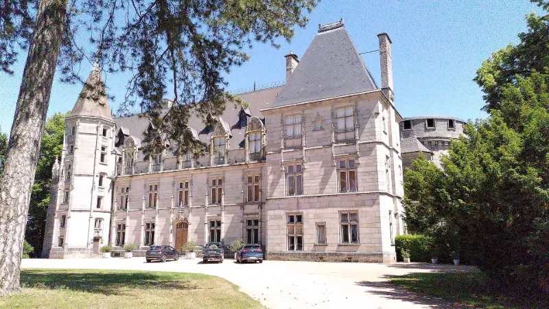
La châtellenie de Chaumont est attestée à la fin du XIe siècle ou au tout début du XIIe siècle. A partir des années 1490-1500, Pierre de Laguiche (1464-1544), conseiller, chambellan et ambassadeur du roi, entreprend la construction d'un nouveau corps de logis dans un style Renaissance inspiré des demeures royales du val de Loire. Le chantier est poursuivi par son fils jusqu'à la fin du XVIe siècle. Le château s'organise alors autour d'une cour orientée et ouverte au nord-est, avec un accès à l'est où est encore conservé un châtelet d'entrée avec son pont-levis. En 1696, la seigneurie de Chaumont devient la propriété de Charles III de Rohan (1655-1727). A la Révolution, le château et son domaine tombent en ruine. Louis de Laguiche prend possession du domaine au début du XIXe siècle. L'aménagement du parc paysager, dans les années 1837-1838, est dû à Châtelain : perspectives paysagères, saut-de-loup, tracé des allées, plantation de bosquets, construction d'une glacière… Entre 1860 et 1875, l'architecte parisien Charles-Jean Laisné propose un projet de reconstruction du château dans un style néo-gothique.
Map and restricted areas
Open in the main mapRestricted zones
Nearby aerodromes
Open aerodromes within 25 km of the spot, heliports included, with their distance and direction from the spot. Near an aerodrome, drone flying is prohibited or height-limited: check the UAS zones map.
| Aerodrome | Type | Distance | Elevation |
|---|---|---|---|
| Montceau Les Mines Airfield | Aerodrome | 14 km NW | 314 m |
| Centre Hospitalier J. Bouveri Heliport | Heliport | 18 km N | 292 m |
| Paray Le Monial Airfield | Aerodrome | 22 km W | 304 m |
| Centre Hospitalier Heliport | Heliport | 24 km W | 251 m |
Aviation weather (METAR and TAF)
LFLN – Saint-Yan Airport VFR
METAR
METAR LFLN 171400Z AUTO 24006KT 200V280 CAVOK 17/10 Q0999 TEMPO FEW030TCU
- Wind
- 240°, 11 km/h
- Visibility
- 10 km or more
- Clouds
- –
- Temperature
- 17 °C, dew point 10 °C
- QNH
- 999 hPa
- Flight category
- VFR: ceiling > 3,000 ft and visibility > 5 mi
TAF
TAF LFLN 171400Z 1715/1724 24012KT CAVOK TEMPO 1719/1724 22020G30KT -SHRA FEW040TCU PROB40 TEMPO 1722/1724 23025G40KT SHRA FEW035CB
| Period (local time) | Change | Wind | Visibility | Weather | Clouds |
|---|---|---|---|---|---|
| 17/11 16:00 → 18/11 01:00 | Initial conditions | 240°, 22 km/h | 10 km or more | No significant weather | No significant cloud |
| 17/11 20:00 → 18/11 01:00 | Temporarily | 220°, 37 km/h, gusts 56 km/h | Showers of rain light | Few (1-2/8) at 4,000 ft (1220 m) (towering cumulus) | |
| 17/11 23:00 → 18/11 01:00 | Temporarily, probability 40% | 230°, 46 km/h, gusts 74 km/h | Showers of rain | Few (1-2/8) at 3,500 ft (1070 m) (cumulonimbus) |
Weather and Kp index
Sunrise and sunset
| Day | Dawn | Sunrise | Golden hour | Sunset | Dusk | Day length |
|---|---|---|---|---|---|---|
| Tue 17 Nov | 07:14 | 07:47 | 07:47–08:34 · 16:21–17:08 | 17:08 | 17:40 | 9 h 20 |
| Wed 18 Nov | 07:15 | 07:48 | 07:48–08:35 · 16:20–17:07 | 17:07 | 17:39 | 9 h 18 |
| Thu 19 Nov | 07:17 | 07:50 | 07:50–08:37 · 16:18–17:06 | 17:06 | 17:39 | 9 h 15 |
| Fri 20 Nov | 07:18 | 07:51 | 07:51–08:39 · 16:17–17:05 | 17:05 | 17:38 | 9 h 13 |
| Sat 21 Nov | 07:19 | 07:53 | 07:53–08:40 · 16:16–17:04 | 17:04 | 17:37 | 9 h 11 |
| Sun 22 Nov | 07:21 | 07:54 | 07:54–08:42 · 16:15–17:03 | 17:03 | 17:36 | 9 h 09 |
| Mon 23 Nov | 07:22 | 07:55 | 07:55–08:43 · 16:14–17:02 | 17:02 | 17:36 | 9 h 06 |

Reviews (0)
Log in to review this spot. Log in · Create a free account
No reviews yet. Share yours!