

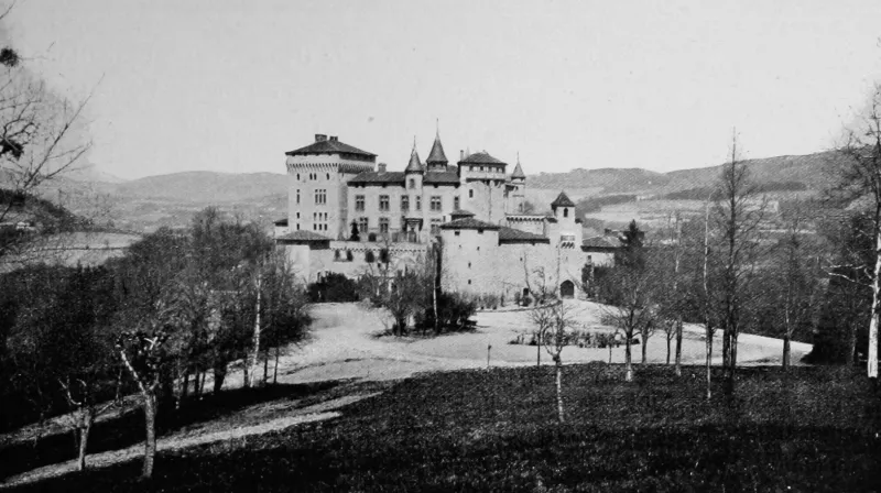
Chamousset Castle
No reviews yet
Have you flown here? Share your experience with other pilots.
+ Write the first reviewHistory
La fondation de Chamousset remonte au 13e siècle. Le château remplaça un manoir plus ancien. Restauré au 19e siècle avec la participation de Viollet-le-Duc et son collaborateur Edmond Duthoit. Entre 1868 et 1870, les premiers travaux consistent en la démolition et la reconstruction de la partie nord du château et du pavillon oriental. Vers 1885, construction du nouveau donjon, du corps de logis sud, de la tour au-dessus de la chapelle, et des bâtiments d'exploitation. De 1892 à 1895, réalisation de l'ensemble des travaux intérieurs de peinture par l'architecte Gelis-Didot, représentatifs des goûts d'une grande famille de l'époque. Salle-à-manger de style néo-médiéval (plafond, poutre à corbeaux, frise peinte, cheminée, boiseries...). La chambre du roi est décorée dans un style néo-Renaissance. La chambre du capitaine des gardes possède une cheminée de style néo-mauresque.
Map and restricted areas
Open in the main mapRestricted zones
| Zone | Category | Limits | Conditions |
|---|---|---|---|
| Zrt Feurs High | ZRT | FL 175 / FL 185 | SUP AIP 055/26 · Du jeudi 16 avril 2026 au mercredi 12 avril 2028 |
Nearby aerodromes
Open aerodromes within 25 km of the spot, heliports included, with their distance and direction from the spot. Near an aerodrome, drone flying is prohibited or height-limited: check the UAS zones map.
| Aerodrome | Type | Distance | Elevation |
|---|---|---|---|
| Lyon Brindas Airfield | Aerodrome | 19 km E | 317 m |
| St Galmier Airfield | Aerodrome | 21 km SW | 386 m |
| Aérodrome de Feurs - Chambéon | Aerodrome | 22 km W | 334 m |
| Villefranche-Tarare Airport | Aerodrome | 22 km NE | 328 m |
Aviation weather (METAR and TAF)
LFMH – Saint-Étienne-Bouthéon Airport VFR
METAR
METAR LFMH 171400Z AUTO 22010KT 190V250 9999 FEW049 19/08 Q1001
- Wind
- 220°, 19 km/h
- Visibility
- 10 km or more
- Clouds
- Few (1-2/8) at 4,900 ft (1490 m)
- Temperature
- 19 °C, dew point 8 °C
- QNH
- 1001 hPa
- Flight category
- VFR: ceiling > 3,000 ft and visibility > 5 mi
TAF
Weather and Kp index
Sunrise and sunset
| Day | Dawn | Sunrise | Golden hour | Sunset | Dusk | Day length |
|---|---|---|---|---|---|---|
| Tue 17 Nov | 07:12 | 07:45 | 07:45–08:31 · 16:24–17:10 | 17:10 | 17:42 | 9 h 24 |
| Wed 18 Nov | 07:14 | 07:46 | 07:46–08:32 · 16:22–17:09 | 17:09 | 17:41 | 9 h 22 |
| Thu 19 Nov | 07:15 | 07:47 | 07:47–08:34 · 16:21–17:08 | 17:08 | 17:40 | 9 h 20 |
| Fri 20 Nov | 07:16 | 07:49 | 07:49–08:35 · 16:20–17:07 | 17:07 | 17:39 | 9 h 18 |
| Sat 21 Nov | 07:17 | 07:50 | 07:50–08:37 · 16:19–17:06 | 17:06 | 17:39 | 9 h 15 |
| Sun 22 Nov | 07:19 | 07:51 | 07:51–08:38 · 16:18–17:05 | 17:05 | 17:38 | 9 h 13 |
| Mon 23 Nov | 07:20 | 07:53 | 07:53–08:40 · 16:17–17:04 | 17:04 | 17:37 | 9 h 11 |

Reviews (0)
Log in to review this spot. Log in · Create a free account
No reviews yet. Share yours!