

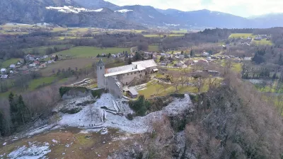
Estate of the Allinges Castles
No reviews yet
Have you flown here? Share your experience with other pilots.
+ Write the first reviewHistory
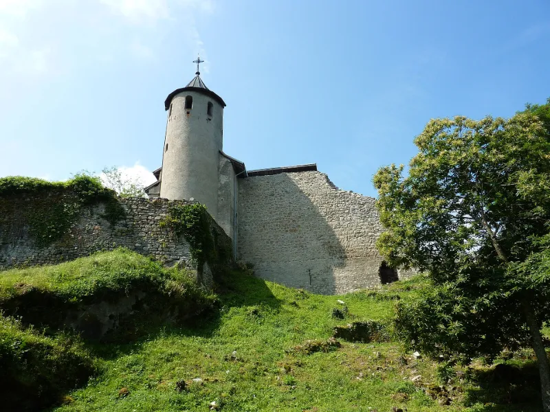
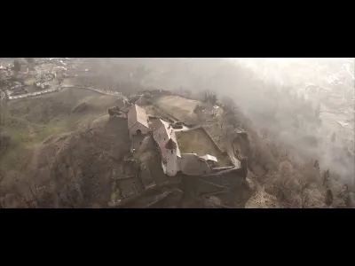
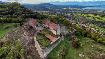
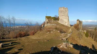
Edifiés sur une crête en forme de croissant, située sur la rive sud du Lac Léman, les deux châteaux des Allinges présentent la caractéristique d'être installés face à face et séparés par une faible distance. Le lignage d'Allinges apparait dans la documentation écrite à la fin du 10ème siècle. Cependant, les deux châteaux ne sont mentionnés ensemble qu'au début du 13ème siècle, bien après leur construction. A cette période, Château-Neuf se trouve en possession de la maison de Savoie, tandis que Château-Vieux appartient aux Sires de Faucigny. A la suite du conflit delphino-savoyard qui perdura de la seconde moitié du 13ème siècle jusqu'au 14ème siècle, Château-Vieux est peu à peu abandonné et seul Château-Neuf reste en usage. Château-Neuf sera finalement démantelé en 1703 par le duc de Savoie dans la crainte de voir cette place forte tomber aux mains des Français. La chapelle de Château-Neuf fera l'objet d'une restauration en 1836 et entre 1842 et 1844, les missionnaires de Saint-François-de-Sales construisirent une habitation à côté de la chapelle, vraisemblablement sur les ruines des anciens bâtiments du château.
Map and restricted areas
Open in the main mapRestricted zones
| Zone | Category | Limits | Conditions |
|---|---|---|---|
| Tma Geneve |
Région de contrôle terminal | 305 m above ground level → 6259 m above sea level · 1067 m above sea level → 6259 m above sea level · 1676 m above sea level → 6259 m above sea level · 1834 m above sea level → 2907 m above sea level · 1834 m above sea level → 6259 m above sea level · 1981 m above sea level → 6259 m above sea level · 2138 m above sea level → 6259 m above sea level · 2443 m above sea level → 6259 m above sea level · 2748 m above sea level → 6259 m above sea level · 3053 m above sea level → 5040 m above sea level · 3053 m above sea level → 6259 m above sea level | Drone flights inside this zone are forbidden without the prior agreement of air traffic control |
Nearby aerodromes
Open aerodromes within 25 km of the spot, heliports included, with their distance and direction from the spot. Near an aerodrome, drone flying is prohibited or height-limited: check the UAS zones map.
| Aerodrome | Type | Distance | Elevation |
|---|---|---|---|
| Societe des Eaux Minerales D'Evian Heliport | Heliport | 7.7 km NE | 387 m |
| Hôtel Royal Heliport | Heliport | 13 km NE | 469 m |
| La Côte Airport | Aerodrome | 18 km NW | 412 m |
| Base ULM Thollon les Mémises | Aerodrome | 21 km E | 913 m |
| Annemasse Airfield | Airport | 21 km SW | 494 m |
Aviation weather (METAR and TAF)
LSGG – Geneva Cointrin International Airport VFR
METAR
METAR LSGG 171220Z AUTO 22014KT 9999 SCT041 14/10 Q1002 TEMPO SHRA
- Wind
- 220°, 26 km/h
- Visibility
- 10 km or more
- Clouds
- Scattered (3-4/8) at 4,100 ft (1250 m)
- Temperature
- 14 °C, dew point 10 °C
- QNH
- 1002 hPa
- Flight category
- VFR: ceiling > 3,000 ft and visibility > 5 mi
TAF
TAF LSGG 171125Z 1712/1818 22010KT 9999 FEW025 BKN050 TX13/1714Z TN10/1805Z TX14/1814Z TEMPO 1712/1715 22015G25KT TEMPO 1723/1803 22015G25KT TEMPO 1723/1804 SHRA
| Period (local time) | Change | Wind | Visibility | Weather | Clouds |
|---|---|---|---|---|---|
| 17/11 13:00 → 18/11 19:00 | Initial conditions | 220°, 19 km/h | 10 km or more | Few (1-2/8) at 2,500 ft (760 m) ; Broken (5-7/8) at 5,000 ft (1520 m) | |
| 17/11 13:00 → 17/11 16:00 | Temporarily | 220°, 28 km/h, gusts 46 km/h | |||
| 18/11 00:00 → 18/11 04:00 | Temporarily | 220°, 28 km/h, gusts 46 km/h | |||
| 18/11 00:00 → 18/11 05:00 | Temporarily | Showers of rain |
Weather and Kp index
| Day | Weather | Temp. min. / max. | Wind | Rain | Max Kp |
|---|---|---|---|---|---|
| Tue 17 Nov | Light rain | 10° / 13° | 34 km/h S | 1.0 mm | 5 |
| Wed 18 Nov | Showers | 8° / 10° | 41 km/h SW | 15 mm | 5 |
| Thu 19 Nov | Partly cloudy | 5° / 9° | 34 km/h SW | 22 mm | 3 |
| Fri 20 Nov | Light rain | 5° / 8° | 31 km/h S | 10 mm | 3 |
| Sat 21 Nov | Fair | 4° / 10° | 19 km/h S | 0.4 mm | – |
| Sun 22 Nov | Showers | 5° / 7° | 17 km/h S | 14 mm | – |
| Mon 23 Nov | Fair | 2° / 8° | 21 km/h S | 4.1 mm | – |
Hour by hour: Tuesday 17 November
| Time | Weather | Temp. | Wind | Rain | Clouds | Kp |
|---|---|---|---|---|---|---|
| 13:00 | Light rain | 12° | 31 km/h S | 0.3 mm | 87 % | 4 |
| 14:00 | Partly cloudy | 12° | 27 km/h SW | – | 58 % | 4 |
| 15:00 | Fair | 13° | 27 km/h SW | – | 38 % | 4 |
| 16:00 | Fair | 13° | 26 km/h S | – | 38 % | 4 |
| 17:00 | Fair | 12° | 20 km/h S | – | 31 % | 4 |
| 18:00 | Clear sky | 10° | 17 km/h S | – | 4 % | 4 |
| 19:00 | Clear sky | 11° | 19 km/h S | – | 0 % | 5 |
| 20:00 | Fair | 11° | 27 km/h S | – | 27 % | 5 |
| 21:00 | Partly cloudy | 12° | 30 km/h S | – | 76 % | 5 |
| 22:00 | Showers | 12° | 32 km/h S | 0.2 mm | 85 % | 5 |
Hour by hour: Wednesday 18 November
| Time | Weather | Temp. | Wind | Rain | Clouds | Kp |
|---|---|---|---|---|---|---|
| 06:00 | Showers | 9° | 41 km/h SW | 1.2 mm | 69 % | 4 |
| 07:00 | Showers | 8° | 29 km/h SW | 0.7 mm | 63 % | 4 |
| 08:00 | Showers | 8° | 26 km/h SW | 0.2 mm | 38 % | 4 |
| 09:00 | Partly cloudy | 9° | 29 km/h SW | – | 56 % | 4 |
| 10:00 | Showers | 10° | 27 km/h SW | 0.1 mm | 75 % | 4 |
| 11:00 | Showers | 10° | 31 km/h SW | 1.7 mm | 77 % | 4 |
| 12:00 | Showers | 9° | 33 km/h SW | 0.5 mm | 62 % | 4 |
| 13:00 | Showers | 10° | 32 km/h SW | 0.3 mm | 61 % | 3 |
| 14:00 | Showers | 10° | 34 km/h SW | 0.3 mm | 58 % | 3 |
| 15:00 | Showers | 10° | 32 km/h SW | 0.3 mm | 70 % | 3 |
| 16:00 | Showers | 10° | 32 km/h SW | 0.3 mm | 80 % | 3 |
| 17:00 | Light rain | 9° | 26 km/h S | 0.3 mm | 97 % | 3 |
| 18:00 | Rain | 8° | 25 km/h S | 0.5 mm | 100 % | 3 |
| 19:00 | Light rain | 8° | 26 km/h S | 0.2 mm | 98 % | 2 |
| 20:00 | Light rain | 8° | 24 km/h S | 0.2 mm | 99 % | 2 |
| 21:00 | Light rain | 8° | 21 km/h S | 0.1 mm | 100 % | 2 |
| 22:00 | Cloudy | 8° | 18 km/h S | – | 97 % | 2 |
Sunrise and sunset
| Day | Dawn | Sunrise | Golden hour | Sunset | Dusk | Day length |
|---|---|---|---|---|---|---|
| Tue 17 Nov | 07:06 | 07:38 | 07:38–08:25 · 16:13–17:00 | 17:00 | 17:33 | 9 h 21 |
| Wed 18 Nov | 07:07 | 07:40 | 07:40–08:26 · 16:12–16:59 | 16:59 | 17:32 | 9 h 19 |
| Thu 19 Nov | 07:08 | 07:41 | 07:41–08:28 · 16:11–16:58 | 16:58 | 17:31 | 9 h 16 |
| Fri 20 Nov | 07:09 | 07:42 | 07:42–08:30 · 16:10–16:57 | 16:57 | 17:30 | 9 h 14 |
| Sat 21 Nov | 07:11 | 07:44 | 07:44–08:31 · 16:09–16:56 | 16:56 | 17:29 | 9 h 12 |
| Sun 22 Nov | 07:12 | 07:45 | 07:45–08:33 · 16:08–16:55 | 16:55 | 17:29 | 9 h 10 |
| Mon 23 Nov | 07:13 | 07:47 | 07:47–08:34 · 16:07–16:55 | 16:55 | 17:28 | 9 h 08 |
Reviews (0)
Log in to review this spot. Log in · Create a free account
No reviews yet. Share yours!