

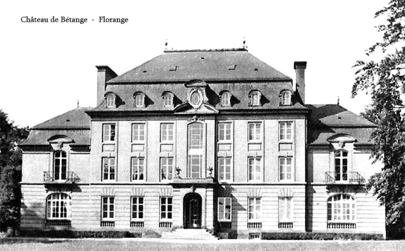
Bétange Estate
No reviews yet
Have you flown here? Share your experience with other pilots.
+ Write the first reviewHistory
Château construit en 1828 puis modifié à plusieurs reprises (1856 ; 1927 ; pendant la Seconde guerre mondiale puis à la libération). Le corps principal est flanqué, dans son prolongement, de deux ailes basses. L'ensemble est entouré d'une cour anglaise sur trois côtés et d'une terrasse s'ouvrant vers le jardin. Il est construit en calcaire jaune. Maçonnerie imitant le bossage à refend au premier niveau, puis moellon enduit. Encadrements et allèges en pierre de taille. Les distributions, restées dans l'état des années 1920, témoignent du mode de vie d'une famille très nombreuse de la haute bourgeoisie : services au sous-sol, salles de réceptions au rez-de-chaussée ornées de boiseries néo-18e, chambres avec salles de bain dans les étages, chambres des domestiques et lingerie dans les combles.
Map and restricted areas
Open in the main mapRestricted zones
| Zone | Category | Limits | Conditions |
|---|---|---|---|
| Saint Dizier | Zone réglementée | 3053 m above sea level → 6259 m above sea level | Vols interdits sauf lorsque the official document of the zone l'autorise explicitement ou avec l'accord du gestionnaire de la zone lorsqu'il est désigné par the official document of the zone |
Nearby aerodromes
Open aerodromes within 25 km of the spot, heliports included, with their distance and direction from the spot. Near an aerodrome, drone flying is prohibited or height-limited: check the UAS zones map.
| Aerodrome | Type | Distance | Elevation |
|---|---|---|---|
| Villerupt Aerodrome | Aerodrome | 18 km NW | 396 m |
| Centre Hospitalier Emile Mayrisch Heliport | Heliport | 21 km NW | 296 m |
| Doncourt Les Conflans Airfield | Aerodrome | 25 km SW | 245 m |
Aviation weather (METAR and TAF)
ELLX – Luxembourg-Findel International Airport VFR
METAR
METAR ELLX 171220Z 26026G36KT 9999 R24/1400N VCSH FEW020 SCT024 14/10 Q0988 TEMPO 25025G40KT
- Wind
- 260°, 48 km/h, gusts 67 km/h
- Visibility
- 10 km or more
- Weather
- Showers of in the vicinity
- Clouds
- Few (1-2/8) at 2,000 ft (610 m) ; Scattered (3-4/8) at 2,400 ft (730 m)
- Temperature
- 14 °C, dew point 10 °C
- QNH
- 988 hPa
- Flight category
- VFR: ceiling > 3,000 ft and visibility > 5 mi
TAF
TAF ELLX 171100Z 1712/1818 23018G30KT 9999 SCT030 TEMPO 1712/1818 23020G35KT 4000 SHRA SCT015TCU BKN020 TEMPO 1719/1724 25025G40KT 2000 SHRA TSRA BKN010CB
| Period (local time) | Change | Wind | Visibility | Weather | Clouds |
|---|---|---|---|---|---|
| 17/11 13:00 → 18/11 19:00 | Initial conditions | 230°, 33 km/h, gusts 56 km/h | 10 km or more | Scattered (3-4/8) at 3,000 ft (910 m) | |
| 17/11 13:00 → 18/11 19:00 | Temporarily | 230°, 37 km/h, gusts 65 km/h | 4.0 km | Showers of rain | Scattered (3-4/8) at 1,500 ft (460 m) (towering cumulus) ; Broken (5-7/8) at 2,000 ft (610 m) |
| 17/11 20:00 → 18/11 01:00 | Temporarily | 250°, 46 km/h, gusts 74 km/h | 2.0 km | Showers of rain ; thunderstorm rain | Broken (5-7/8) at 1,000 ft (300 m) (cumulonimbus) |
Weather and Kp index
| Day | Weather | Temp. min. / max. | Wind | Rain | Max Kp |
|---|---|---|---|---|---|
| Tue 17 Nov | Light rain | 10° / 14° | 33 km/h SW | 12 mm | 5 |
| Wed 18 Nov | Showers | 8° / 11° | 32 km/h SW | 5.9 mm | 5 |
| Thu 19 Nov | Cloudy | 8° / 10° | 32 km/h SW | 12 mm | 3 |
| Fri 20 Nov | Light rain | 8° / 9° | 25 km/h W | 12 mm | 3 |
| Sat 21 Nov | Clear sky | 3° / 8° | 17 km/h SW | 2.8 mm | – |
| Sun 22 Nov | Rain | 0° / 4° | 12 km/h E | 7.1 mm | – |
| Mon 23 Nov | Light rain | 6° / 8° | 20 km/h SW | 1.1 mm | – |
Hour by hour: Tuesday 17 November
| Time | Weather | Temp. | Wind | Rain | Clouds | Kp |
|---|---|---|---|---|---|---|
| 13:00 | Light rain | 13° | 33 km/h SW | 0.1 mm | 99 % | 4 |
| 14:00 | Showers | 14° | 29 km/h W | 0.2 mm | 80 % | 4 |
| 15:00 | Fair | 14° | 28 km/h SW | – | 33 % | 4 |
| 16:00 | Rain | 13° | 26 km/h SW | 0.6 mm | 88 % | 4 |
| 17:00 | Heavy rain | 12° | 27 km/h SW | 1.3 mm | 100 % | 4 |
| 18:00 | Heavy rain | 10° | 24 km/h SW | 1.4 mm | 98 % | 4 |
| 19:00 | Heavy rain | 10° | 23 km/h SW | 1.8 mm | 100 % | 5 |
| 20:00 | Heavy rain | 10° | 24 km/h SW | 1.8 mm | 100 % | 5 |
| 21:00 | Heavy rain | 10° | 26 km/h SW | 1.5 mm | 100 % | 5 |
| 22:00 | Heavy rain | 10° | 28 km/h SW | 2.4 mm | 100 % | 5 |
Hour by hour: Wednesday 18 November
| Time | Weather | Temp. | Wind | Rain | Clouds | Kp |
|---|---|---|---|---|---|---|
| 06:00 | Rain | 9° | 28 km/h SW | 0.6 mm | 100 % | 4 |
| 07:00 | Light rain | 9° | 32 km/h SW | 0.2 mm | 100 % | 4 |
| 08:00 | Light rain | 9° | 28 km/h SW | 0.2 mm | 99 % | 4 |
| 09:00 | Light rain | 9° | 28 km/h SW | 0.2 mm | 100 % | 4 |
| 10:00 | Light rain | 10° | 30 km/h SW | 0.1 mm | 100 % | 4 |
| 11:00 | Showers | 10° | 32 km/h SW | 0.6 mm | 84 % | 4 |
| 12:00 | Rain | 10° | 32 km/h W | 0.6 mm | 89 % | 4 |
| 13:00 | Showers | 10° | 31 km/h W | 0.4 mm | 71 % | 3 |
| 14:00 | Showers | 11° | 30 km/h W | 0.4 mm | 74 % | 3 |
| 15:00 | Showers | 10° | 29 km/h SW | 0.3 mm | 56 % | 3 |
| 16:00 | Showers | 10° | 27 km/h W | 0.2 mm | 59 % | 3 |
| 17:00 | Partly cloudy | 9° | 26 km/h W | – | 76 % | 3 |
| 18:00 | Partly cloudy | 9° | 23 km/h SW | – | 69 % | 3 |
| 19:00 | Showers | 9° | 23 km/h SW | 0.2 mm | 64 % | 2 |
| 20:00 | Partly cloudy | 9° | 23 km/h SW | – | 45 % | 2 |
| 21:00 | Fair | 8° | 21 km/h SW | – | 36 % | 2 |
| 22:00 | Partly cloudy | 8° | 20 km/h SW | – | 48 % | 2 |
Sunrise and sunset
| Day | Dawn | Sunrise | Golden hour | Sunset | Dusk | Day length |
|---|---|---|---|---|---|---|
| Tue 17 Nov | 07:14 | 07:49 | 07:49–08:40 · 16:01–16:52 | 16:52 | 17:27 | 9 h 02 |
| Wed 18 Nov | 07:16 | 07:51 | 07:51–08:42 · 16:00–16:51 | 16:51 | 17:26 | 8 h 59 |
| Thu 19 Nov | 07:17 | 07:52 | 07:52–08:44 · 15:58–16:49 | 16:49 | 17:25 | 8 h 57 |
| Fri 20 Nov | 07:18 | 07:54 | 07:54–08:45 · 15:57–16:48 | 16:48 | 17:24 | 8 h 54 |
| Sat 21 Nov | 07:20 | 07:55 | 07:55–08:47 · 15:56–16:47 | 16:47 | 17:23 | 8 h 52 |
| Sun 22 Nov | 07:21 | 07:57 | 07:57–08:49 · 15:54–16:46 | 16:46 | 17:22 | 8 h 49 |
| Mon 23 Nov | 07:23 | 07:58 | 07:58–08:51 · 15:53–16:45 | 16:45 | 17:21 | 8 h 47 |
Reviews (0)
Log in to review this spot. Log in · Create a free account
No reviews yet. Share yours!