

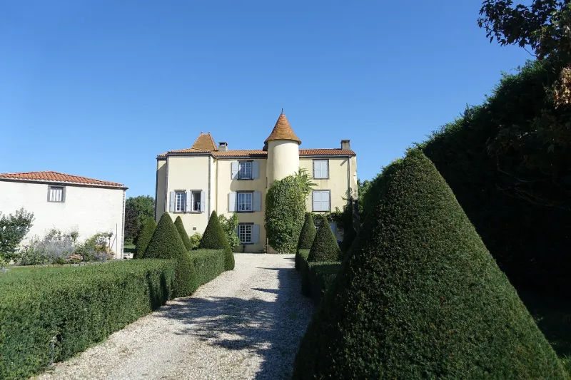
La Pause Castle
No reviews yet
Have you flown here? Share your experience with other pilots.
+ Write the first reviewHistory
La Pause était un petit fief dépendant à l'origine de la seigneurie de Pessat, mentionné pour la première fois en 1560. Christophe Duboys, contrôleur général des finances à Riom, fut sans doute le commanditaire du château actuel au 17e siècle. Ses armoiries subsistent à l'intérieur. La Pause est constituée d'une gentilhommière du 17e entourée de dépendances agricoles. A l'origine, le corps de logis était accosté, pour sa façade antérieure ouest, de deux avants-corps latéraux, et flanqué en son centre d'une tourelle d'escalier circulaire hors-oeuvre. L'avant-corps sud qui comprenait une chapelle a été détruit. Cet édifice mérite une attention particulière de par le décor intérieur original qui a été conservé dans toute son authenticité depuis le 17e siècle. Outre les sols, plafonds et cheminées, il présente un décor peint avec motifs géométriques, blasons, vue du château... Il s'agit d'une imitation en peinture d'un décor de lambris à grands cadres tel qu'on en trouve en France dans le milieu du 17e siècle.
Map and restricted areas
Open in the main mapRestricted zones
Nearby aerodromes
Open aerodromes within 25 km of the spot, heliports included, with their distance and direction from the spot. Near an aerodrome, drone flying is prohibited or height-limited: check the UAS zones map.
| Aerodrome | Type | Distance | Elevation |
|---|---|---|---|
| Clermont-Ferrand Auvergne Airport | Airport | 15 km S | 332 m |
| Centre Hospitalier Heliport | Heliport | 19 km S | 416 m |
Aviation weather (METAR and TAF)
LFLC – Clermont-Ferrand Auvergne Airport VFR
METAR
METAR LFLC 171400Z AUTO 15012G27KT 120V190 9999 BKN053 BKN190 OVC210 18/08 Q1000
- Wind
- 150°, 22 km/h, gusts 50 km/h
- Visibility
- 10 km or more
- Clouds
- Broken (5-7/8) at 5,300 ft (1620 m) ; Broken (5-7/8) at 19,000 ft (5790 m) ; Overcast (8/8) at 21,000 ft (6400 m)
- Temperature
- 18 °C, dew point 8 °C
- QNH
- 1000 hPa
- Flight category
- VFR: ceiling > 3,000 ft and visibility > 5 mi
TAF
TAF LFLC 170500Z 1706/1806 19012KT CAVOK TEMPO 1706/1710 19018G30KT -RA BKN050 PROB30 TEMPO 1707/1710 22025G45KT RA BKN020 FM171000 22012KT CAVOK TEMPO 1710/1717 22018G30KT PROB30 TEMPO 1714/1717 -SHRA BKN060TCU FM171700 25015KT CAVOK TEMPO 1717/1806 25018G30KT PROB30 TEMPO 1720/1723 25025G45KT SHRA BKN060TCU
| Period (local time) | Change | Wind | Visibility | Weather | Clouds |
|---|---|---|---|---|---|
| 17/11 07:00 → 17/11 11:00 | Initial conditions | 190°, 22 km/h | 10 km or more | No significant weather | No significant cloud |
| 17/11 07:00 → 17/11 11:00 | Temporarily | 190°, 33 km/h, gusts 56 km/h | Rain light | Broken (5-7/8) at 5,000 ft (1520 m) | |
| 17/11 08:00 → 17/11 11:00 | Temporarily, probability 30% | 220°, 46 km/h, gusts 83 km/h | Rain | Broken (5-7/8) at 2,000 ft (610 m) | |
| 17/11 11:00 → 17/11 18:00 | From | 220°, 22 km/h | 10 km or more | No significant weather | No significant cloud |
| 17/11 11:00 → 17/11 18:00 | Temporarily | 220°, 33 km/h, gusts 56 km/h | |||
| 17/11 15:00 → 17/11 18:00 | Temporarily, probability 30% | Showers of rain light | Broken (5-7/8) at 6,000 ft (1830 m) (towering cumulus) | ||
| 17/11 18:00 → 18/11 07:00 | Temporarily | 250°, 33 km/h, gusts 56 km/h | |||
| 17/11 18:00 → 18/11 07:00 | From | 250°, 28 km/h | 10 km or more | No significant weather | No significant cloud |
| 17/11 21:00 → 18/11 00:00 | Temporarily, probability 30% | 250°, 46 km/h, gusts 83 km/h | Showers of rain | Broken (5-7/8) at 6,000 ft (1830 m) (towering cumulus) |
Weather and Kp index
Sunrise and sunset
| Day | Dawn | Sunrise | Golden hour | Sunset | Dusk | Day length |
|---|---|---|---|---|---|---|
| Tue 17 Nov | 07:18 | 07:50 | 07:50–08:36 · 16:28–17:14 | 17:14 | 17:47 | 9 h 23 |
| Wed 18 Nov | 07:19 | 07:52 | 07:52–08:38 · 16:27–17:13 | 17:13 | 17:46 | 9 h 21 |
| Thu 19 Nov | 07:20 | 07:53 | 07:53–08:40 · 16:26–17:12 | 17:12 | 17:45 | 9 h 19 |
| Fri 20 Nov | 07:22 | 07:54 | 07:54–08:41 · 16:25–17:11 | 17:11 | 17:44 | 9 h 17 |
| Sat 21 Nov | 07:23 | 07:56 | 07:56–08:43 · 16:24–17:11 | 17:11 | 17:43 | 9 h 14 |
| Sun 22 Nov | 07:24 | 07:57 | 07:57–08:44 · 16:23–17:10 | 17:10 | 17:43 | 9 h 12 |
| Mon 23 Nov | 07:25 | 07:58 | 07:58–08:46 · 16:22–17:09 | 17:09 | 17:42 | 9 h 10 |
Reviews (0)
Log in to review this spot. Log in · Create a free account
No reviews yet. Share yours!