

Grand Daubeuf Estate
No reviews yet
Have you flown here? Share your experience with other pilots.
+ Write the first reviewHistory
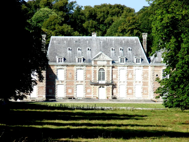
Le château attribué à François Mansart, a été construit en 1629, ainsi que le domaine enclos.. Le château avec corps de logis flanqué de deux pavillons construits sur une légère éminence est très caractéristique des constructions de la fin du règne de Louis XIII. Malgré les travaux d'amélioration du 19e siècle, il est encore très représentatif de cette architecture robuste mais très soignée. Le parc a été redessiné au 18e siècle, des perspectives ont été créées se prolongeant à l'extérieur du domaine au-delà du saut-de-loup. Dans son emprise foncière et dans sa composition, les grandes lignes en sont préservées, y compris la clôture. Au 19e siècle, il a été modifié par Bühler (adjonction de la pièce d'eau et du jardin bas). L'ensemble des dépendances, construites par Alexandre Pinchon et E. Boulanger dans la seconde moitié du 19e siècle, sont d'un intérêt moindre, sauf en ce qui concerne les grandes écuries réalisées selon un parti ambitieux avec leur grand hall éclairé d'une verrière et leurs amples ailes en hémicycle. L'intérêt de ce château vient surtout de son mobilier, ensemble exceptionnel dont il n'est pas douteux qu'en partie il ait été conçu ou acquis pour ce château et ne l'ait pas quitté depuis le 18e siècle.
Map and restricted areas
Open in the main mapRestricted zones
Nearby aerodromes
Open aerodromes within 25 km of the spot, heliports included, with their distance and direction from the spot. Near an aerodrome, drone flying is prohibited or height-limited: check the UAS zones map.
| Aerodrome | Type | Distance | Elevation |
|---|---|---|---|
| Centre Hospitalier Heliport | Heliport | 7.8 km NW | 97 m |
| Aérodrome de Saint-Valery-Vittefleur | Aerodrome | 19 km NE | 83 m |
| Centrale Nucléaire Heliport | Heliport | 20 km NE | 93 m |
| Yvetot-Baons Le Comte Airfield | Aerodrome | 20 km SE | 142 m |
| Aérodrome du Havre - Saint-Romain | Aerodrome | 20 km SW | 129 m |
Aviation weather (METAR and TAF)
LFOH – Le Havre Octeville Airport VFR
METAR
METAR LFOH 171330Z AUTO 22019KT 9999 BKN034/// BKN120/// ///TCU 14/10 Q0987 TEMPO VRB30G40KT 2500 -TSRAGS BKN012CB
- Wind
- 220°, 35 km/h
- Visibility
- 10 km or more
- Clouds
- Broken (5-7/8) at 3,400 ft (1040 m) ; Broken (5-7/8) at 12,000 ft (3660 m)
- Temperature
- 14 °C, dew point 10 °C
- QNH
- 987 hPa
- Flight category
- VFR: ceiling > 3,000 ft and visibility > 5 mi
TAF
TAF LFOH 171100Z 1712/1812 24020G30KT 9999 BKN020 TEMPO 1712/1812 VRB30G40KT 4000 SHRA BKN030TCU PROB40 TEMPO 1713/1812 2500 -TSRAGS BKN012CB
| Period (local time) | Change | Wind | Visibility | Weather | Clouds |
|---|---|---|---|---|---|
| 17/11 13:00 → 18/11 13:00 | Initial conditions | 240°, 37 km/h, gusts 56 km/h | 10 km or more | Broken (5-7/8) at 2,000 ft (610 m) | |
| 17/11 13:00 → 18/11 13:00 | Temporarily | Variable, 56 km/h, gusts 74 km/h | 4.0 km | Showers of rain | Broken (5-7/8) at 3,000 ft (910 m) (towering cumulus) |
| 17/11 14:00 → 18/11 13:00 | Temporarily, probability 40% | 2.5 km | Thunderstorm rain light ; thunderstorm small hail light | Broken (5-7/8) at 1,200 ft (370 m) (cumulonimbus) |
Weather and Kp index
| Day | Weather | Temp. min. / max. | Wind | Rain | Max Kp |
|---|---|---|---|---|---|
| Tue 17 Nov | Heavy rain | 10° / 11° | 54 km/h SW | 13 mm | 5 |
| Wed 18 Nov | Heavy rain | 9° / 12° | 49 km/h SW | 17 mm | 5 |
| Thu 19 Nov | Showers | 8° / 11° | 45 km/h SW | 18 mm | 3 |
| Fri 20 Nov | Showers | 9° / 11° | 40 km/h SW | 18 mm | 3 |
| Sat 21 Nov | Partly cloudy | 8° / 11° | 22 km/h W | 1.2 mm | – |
| Sun 22 Nov | Light rain | 6° / 8° | 24 km/h SE | 11 mm | – |
| Mon 23 Nov | Partly cloudy | 7° / 10° | 21 km/h W | 6.2 mm | – |
Hour by hour: Tuesday 17 November
| Time | Weather | Temp. | Wind | Rain | Clouds | Kp |
|---|---|---|---|---|---|---|
| 15:00 | Heavy rain | 11° | 40 km/h SW | 2.8 mm | 100 % | 4 |
| 16:00 | Heavy rain | 11° | 46 km/h SW | 3.1 mm | 100 % | 4 |
| 17:00 | Heavy rain | 11° | 54 km/h SW | 2.9 mm | 100 % | 4 |
| 18:00 | Rain | 11° | 51 km/h SW | 0.5 mm | 100 % | 4 |
| 19:00 | Rain | 11° | 46 km/h SW | 0.9 mm | 94 % | 5 |
| 20:00 | Showers | 10° | 42 km/h SW | 0.4 mm | 82 % | 5 |
| 21:00 | Showers | 10° | 39 km/h SW | 0.8 mm | 67 % | 5 |
| 22:00 | Rain | 10° | 42 km/h W | 0.8 mm | 97 % | 5 |
Hour by hour: Wednesday 18 November
| Time | Weather | Temp. | Wind | Rain | Clouds | Kp |
|---|---|---|---|---|---|---|
| 06:00 | Rain | 10° | 43 km/h SW | 0.8 mm | 99 % | 4 |
| 07:00 | Rain | 10° | 45 km/h SW | 0.5 mm | 98 % | 4 |
| 08:00 | Heavy rain | 10° | 42 km/h SW | 1.2 mm | 98 % | 4 |
| 09:00 | Rain | 10° | 40 km/h SW | 0.8 mm | 94 % | 4 |
| 10:00 | Rain | 10° | 42 km/h SW | 0.9 mm | 100 % | 4 |
| 11:00 | Rain | 10° | 46 km/h SW | 0.5 mm | 99 % | 4 |
| 12:00 | Heavy rain | 10° | 46 km/h SW | 1.1 mm | 98 % | 4 |
| 13:00 | Heavy rain | 11° | 43 km/h SW | 1.5 mm | 93 % | 3 |
| 14:00 | Showers | 11° | 44 km/h W | 0.2 mm | 86 % | 3 |
| 15:00 | Showers | 12° | 40 km/h SW | 0.1 mm | 44 % | 3 |
| 16:00 | Showers | 12° | 39 km/h SW | 0.4 mm | 65 % | 3 |
| 17:00 | Showers | 10° | 36 km/h SW | 0.2 mm | 70 % | 3 |
| 18:00 | Cloudy | 10° | 32 km/h SW | – | 94 % | 3 |
| 19:00 | Cloudy | 10° | 28 km/h SW | – | 95 % | 2 |
| 20:00 | Heavy rain | 10° | 24 km/h S | 1.8 mm | 100 % | 2 |
| 21:00 | Heavy rain | 9° | 27 km/h S | 1.3 mm | 100 % | 2 |
| 22:00 | Heavy rain | 9° | 32 km/h S | 1.4 mm | 91 % | 2 |
Sunrise and sunset
| Day | Dawn | Sunrise | Golden hour | Sunset | Dusk | Day length |
|---|---|---|---|---|---|---|
| Tue 17 Nov | 07:38 | 08:13 | 08:13–09:04 · 16:22–17:13 | 17:13 | 17:48 | 8 h 59 |
| Wed 18 Nov | 07:39 | 08:15 | 08:15–09:06 · 16:20–17:12 | 17:12 | 17:47 | 8 h 57 |
| Thu 19 Nov | 07:41 | 08:16 | 08:16–09:08 · 16:19–17:11 | 17:11 | 17:46 | 8 h 54 |
| Fri 20 Nov | 07:42 | 08:18 | 08:18–09:10 · 16:18–17:10 | 17:10 | 17:45 | 8 h 51 |
| Sat 21 Nov | 07:43 | 08:19 | 08:19–09:12 · 16:16–17:09 | 17:09 | 17:44 | 8 h 49 |
| Sun 22 Nov | 07:45 | 08:21 | 08:21–09:13 · 16:15–17:08 | 17:08 | 17:44 | 8 h 46 |
| Mon 23 Nov | 07:46 | 08:22 | 08:22–09:15 · 16:14–17:07 | 17:07 | 17:43 | 8 h 44 |

Reviews (0)
Log in to review this spot. Log in · Create a free account
No reviews yet. Share yours!