

Cliffe Fort
No reviews yet
Have you flown here? Share your experience with other pilots.
+ Write the first reviewHistory
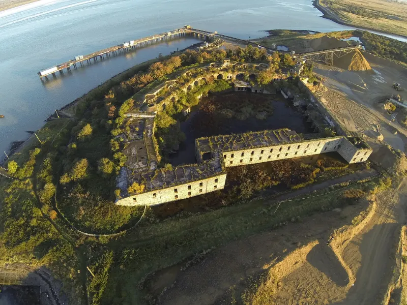
Cliffe Fort is a disused artillery fort built in the 1860s to guard the entrance to the River Thames. It stands on the south bank of the river at the entrance to Cliffe Creek, in the Cliffe marshes on the Hoo Peninsula in North Kent. Its marshy location caused problems from the start of construction.
Map and restricted areas
Open in the main mapRestricted zones
Nearby aerodromes
Open aerodromes within 25 km of the spot, heliports included, with their distance and direction from the spot. Near an aerodrome, drone flying is prohibited or height-limited: check the UAS zones map.
| Aerodrome | Type | Distance | Elevation |
|---|---|---|---|
| Thurrock Airfield | Aerodrome | 10 km NW | 6 m |
| Stoke Airfield | Aerodrome | 12 km E | 5 m |
| Rochester Airport | Aerodrome | 13 km S | 133 m |
| Barnards Farm | Aerodrome | 13 km NW | 24 m |
| Bensons Farm Airstrip | Aerodrome | 14 km N | 24 m |
Aviation weather (METAR and TAF)
EGMC – Southend Airport VFR
METAR
METAR EGMC 171220Z 24021G31KT 9999 VCSH FEW023 SCT031 13/08 Q0980
- Wind
- 240°, 39 km/h, gusts 57 km/h
- Visibility
- 10 km or more
- Weather
- Showers of in the vicinity
- Clouds
- Few (1-2/8) at 2,300 ft (700 m) ; Scattered (3-4/8) at 3,100 ft (940 m)
- Temperature
- 13 °C, dew point 8 °C
- QNH
- 980 hPa
- Flight category
- VFR: ceiling > 3,000 ft and visibility > 5 mi
TAF
TAF EGMC 171104Z 1712/1721 22015G25KT 9999 SCT025 PROB40 TEMPO 1712/1718 23025G35KT PROB30 TEMPO 1712/1721 3000 +SHRA BKN014
| Period (local time) | Change | Wind | Visibility | Weather | Clouds |
|---|---|---|---|---|---|
| 17/11 12:00 → 17/11 21:00 | Initial conditions | 220°, 28 km/h, gusts 46 km/h | 10 km or more | Scattered (3-4/8) at 2,500 ft (760 m) | |
| 17/11 12:00 → 17/11 21:00 | Temporarily, probability 30% | 3.0 km | Showers of rain heavy | Broken (5-7/8) at 1,400 ft (430 m) | |
| 17/11 12:00 → 17/11 18:00 | Temporarily, probability 40% | 230°, 46 km/h, gusts 65 km/h |
Weather and Kp index
| Day | Weather | Temp. min. / max. | Wind | Rain | Max Kp |
|---|---|---|---|---|---|
| Tue 17 Nov | Partly cloudy | 9° / 13° | 32 km/h SW | – | 5 |
| Wed 18 Nov | Partly cloudy | 9° / 12° | 25 km/h W | 6.2 mm | 5 |
| Thu 19 Nov | Cloudy | 6° / 10° | 13 km/h NW | 5.0 mm | 3 |
| Fri 20 Nov | Light rain | 8° / 9° | 18 km/h NE | 5.4 mm | 3 |
| Sat 21 Nov | Fair | 2° / 8° | 10 km/h N | – | – |
| Sun 22 Nov | Cloudy | 6° / 8° | 22 km/h E | 0.5 mm | – |
| Mon 23 Nov | Cloudy | 5° / 9° | 17 km/h W | 2.6 mm | – |
Hour by hour: Tuesday 17 November
| Time | Weather | Temp. | Wind | Rain | Clouds | Kp |
|---|---|---|---|---|---|---|
| 12:00 | Clear sky | 13° | 32 km/h SW | – | 12 % | 4 |
| 13:00 | Partly cloudy | 13° | 32 km/h SW | – | 63 % | 4 |
| 14:00 | Partly cloudy | 13° | 28 km/h SW | – | 41 % | 4 |
| 15:00 | Partly cloudy | 13° | 25 km/h SW | – | 72 % | 4 |
| 16:00 | Cloudy | 12° | 21 km/h SW | – | 91 % | 4 |
| 17:00 | Cloudy | 11° | 21 km/h SW | – | 98 % | 4 |
| 18:00 | Fair | 11° | 19 km/h SW | – | 20 % | 5 |
| 19:00 | Fair | 10° | 20 km/h W | – | 15 % | 5 |
| 20:00 | Clear sky | 10° | 21 km/h W | – | 6 % | 5 |
| 21:00 | Fair | 9° | 21 km/h W | – | 32 % | 5 |
| 22:00 | Partly cloudy | 9° | 22 km/h W | – | 57 % | 5 |
Hour by hour: Wednesday 18 November
| Time | Weather | Temp. | Wind | Rain | Clouds | Kp |
|---|---|---|---|---|---|---|
| 06:00 | Fair | 9° | 19 km/h W | – | 14 % | 4 |
| 07:00 | Clear sky | 9° | 18 km/h W | – | 6 % | 4 |
| 08:00 | Fair | 9° | 18 km/h W | – | 18 % | 4 |
| 09:00 | Partly cloudy | 10° | 18 km/h W | – | 43 % | 4 |
| 10:00 | Partly cloudy | 11° | 17 km/h SW | – | 91 % | 4 |
| 11:00 | Fair | 12° | 20 km/h SW | – | 24 % | 4 |
| 12:00 | Partly cloudy | 12° | 25 km/h W | – | 48 % | 3 |
| 13:00 | Partly cloudy | 12° | 24 km/h W | – | 38 % | 3 |
| 14:00 | Partly cloudy | 12° | 19 km/h SW | – | 41 % | 3 |
| 15:00 | Fair | 12° | 17 km/h SW | – | 18 % | 3 |
| 16:00 | Fair | 11° | 18 km/h SW | – | 13 % | 3 |
| 17:00 | Fair | 11° | 15 km/h SW | – | 20 % | 3 |
| 18:00 | Partly cloudy | 10° | 18 km/h SW | – | 91 % | 2 |
| 19:00 | Partly cloudy | 9° | 14 km/h SW | – | 99 % | 2 |
| 20:00 | Cloudy | 9° | 14 km/h SW | – | 100 % | 2 |
| 21:00 | Cloudy | 9° | 16 km/h S | – | 100 % | 2 |
| 22:00 | Heavy rain | 10° | 15 km/h S | 1.6 mm | 100 % | 2 |
Sunrise and sunset
| Day | Dawn | Sunrise | Golden hour | Sunset | Dusk | Day length |
|---|---|---|---|---|---|---|
| Tue 17 Nov | 06:42 | 07:20 | 07:20–08:14 · 15:12–16:07 | 16:07 | 16:44 | 8 h 47 |
| Wed 18 Nov | 06:44 | 07:21 | 07:21–08:16 · 15:11–16:05 | 16:05 | 16:43 | 8 h 44 |
| Thu 19 Nov | 06:46 | 07:23 | 07:23–08:18 · 15:09–16:04 | 16:04 | 16:42 | 8 h 41 |
| Fri 20 Nov | 06:47 | 07:24 | 07:24–08:20 · 15:08–16:03 | 16:03 | 16:41 | 8 h 38 |
| Sat 21 Nov | 06:49 | 07:26 | 07:26–08:22 · 15:06–16:02 | 16:02 | 16:40 | 8 h 35 |
| Sun 22 Nov | 06:50 | 07:28 | 07:28–08:24 · 15:05–16:01 | 16:01 | 16:39 | 8 h 33 |
| Mon 23 Nov | 06:51 | 07:29 | 07:29–08:25 · 15:04–16:00 | 16:00 | 16:38 | 8 h 30 |
Reviews (0)
Log in to review this spot. Log in · Create a free account
No reviews yet. Share yours!