

Saint-Clément Church
No reviews yet
Have you flown here? Share your experience with other pilots.
+ Write the first reviewHistory
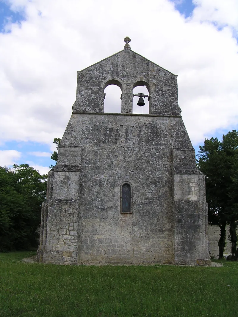
12e siècle Dès le 8e siècle, l'église appartenait à l'abbaye de Saint-Cybard. Elle fut reconstruite dans le deuxième quart du 12e siècle. C'est un petit édifice roman à campanile double, dont les trois coupoles et le cul de four sont tombés et ont été remplacés par une charpente basse et un plafond de planches. La porte romane d'origine, à trois voussures, est située au sud. Au-dessus de la façade occidentale s'élève un clocher-mur ouvert de deux baies plein cintre. Au-dessus du pignon du clocher se dresse une croix en pierre. Le vaisseau de la nef est composé de six colonnes adossées qui supportaient une voûte en berceau de pierre partant d'un bandeau en chanfrein, aujourd'hui remplacé par une voûte en plein cintre en bois.
Map and restricted areas
Open in the main mapRestricted zones
| Zone | Category | Limits | Conditions |
|---|---|---|---|
| Cognac | Zone réglementée | 457 m above sea level → 2297 m above sea level | Vols interdits sauf lorsque the official document of the zone l'autorise explicitement ou avec l'accord du gestionnaire de la zone lorsqu'il est désigné par the official document of the zone |
| Cognac | Zone réglementée | 1006 m above sea level → 1219 m above sea level | Vols interdits sauf lorsque the official document of the zone l'autorise explicitement ou avec l'accord du gestionnaire de la zone lorsqu'il est désigné par the official document of the zone |
| Cognac | Zone réglementée | 1219 m above sea level → 2297 m above sea level | Vols interdits sauf lorsque the official document of the zone l'autorise explicitement ou avec l'accord du gestionnaire de la zone lorsqu'il est désigné par the official document of the zone |
| Cognac | Zone réglementée | 1529 m above sea level → 6259 m above sea level | Vols interdits sauf lorsque the official document of the zone l'autorise explicitement ou avec l'accord du gestionnaire de la zone lorsqu'il est désigné par the official document of the zone |
Nearby aerodromes
Open aerodromes within 25 km of the spot, heliports included, with their distance and direction from the spot. Near an aerodrome, drone flying is prohibited or height-limited: check the UAS zones map.
| Aerodrome | Type | Distance | Elevation |
|---|---|---|---|
| Angoulême-Brie-Champniers Airport | Airport | 24 km SE | 133 m |
Aviation weather (METAR and TAF)
LFBU – Angoulême-Brie-Champniers Airport VFR
METAR
METAR LFBU 171330Z AUTO 22012KT 190V250 9999 BKN032 BKN038 OVC190 18/12 Q1001 TEMPO 24015G25KT 4000 SHRA BKN008 BKN020TCU
- Wind
- 220°, 22 km/h
- Visibility
- 10 km or more
- Clouds
- Broken (5-7/8) at 3,200 ft (980 m) ; Broken (5-7/8) at 3,800 ft (1160 m) ; Overcast (8/8) at 19,000 ft (5790 m)
- Temperature
- 18 °C, dew point 12 °C
- QNH
- 1001 hPa
- Flight category
- VFR: ceiling > 3,000 ft and visibility > 5 mi
TAF
TAF LFBU 171100Z 1712/1812 24010KT 9999 BKN025 TEMPO 1712/1812 24015G25KT 4000 SHRA BKN008 BKN020TCU PROB30 TEMPO 1720/1724 24020G40KT 2000 TSRA BKN008 BKN020CB PROB30 TEMPO 1809/1812 25015G40KT 1500 TSRA BKN008 BKN020CB
| Period (local time) | Change | Wind | Visibility | Weather | Clouds |
|---|---|---|---|---|---|
| 17/11 13:00 → 18/11 13:00 | Initial conditions | 240°, 19 km/h | 10 km or more | Broken (5-7/8) at 2,500 ft (760 m) | |
| 17/11 13:00 → 18/11 13:00 | Temporarily | 240°, 28 km/h, gusts 46 km/h | 4.0 km | Showers of rain | Broken (5-7/8) at 800 ft (240 m) ; Broken (5-7/8) at 2,000 ft (610 m) (towering cumulus) |
| 17/11 21:00 → 18/11 01:00 | Temporarily, probability 30% | 240°, 37 km/h, gusts 74 km/h | 2.0 km | Thunderstorm rain | Broken (5-7/8) at 800 ft (240 m) ; Broken (5-7/8) at 2,000 ft (610 m) (cumulonimbus) |
| 18/11 10:00 → 18/11 13:00 | Temporarily, probability 30% | 250°, 28 km/h, gusts 74 km/h | 1.5 km | Thunderstorm rain | Broken (5-7/8) at 800 ft (240 m) ; Broken (5-7/8) at 2,000 ft (610 m) (cumulonimbus) |
Weather and Kp index
| Day | Weather | Temp. min. / max. | Wind | Rain | Max Kp |
|---|---|---|---|---|---|
| Tue 17 Nov | Showers | 13° / 17° | 33 km/h SW | 12 mm | 5 |
| Wed 18 Nov | Light rain | 11° / 14° | 27 km/h SW | 13 mm | 5 |
| Thu 19 Nov | Showers | 10° / 13° | 33 km/h SW | 12 mm | 3 |
| Fri 20 Nov | Rain | 9° / 14° | 24 km/h SW | 12 mm | 3 |
| Sat 21 Nov | Cloudy | 8° / 13° | 16 km/h SE | 3.6 mm | – |
| Sun 22 Nov | Showers | 10° / 13° | 27 km/h W | 10 mm | – |
| Mon 23 Nov | Cloudy | 8° / 14° | 12 km/h S | 0.1 mm | – |
Hour by hour: Tuesday 17 November
| Time | Weather | Temp. | Wind | Rain | Clouds | Kp |
|---|---|---|---|---|---|---|
| 15:00 | Showers | 17° | 32 km/h SW | 0.1 mm | 48 % | 4 |
| 16:00 | Rain | 16° | 33 km/h SW | 0.6 mm | 92 % | 4 |
| 17:00 | Showers | 15° | 32 km/h SW | 0.1 mm | 68 % | 4 |
| 18:00 | Rain | 14° | 30 km/h SW | 1.0 mm | 99 % | 4 |
| 19:00 | Light rain | 13° | 30 km/h SW | 0.3 mm | 100 % | 5 |
| 20:00 | Rain | 14° | 30 km/h SW | 0.7 mm | 100 % | 5 |
| 21:00 | Heavy rain | 14° | 32 km/h SW | 1.7 mm | 100 % | 5 |
| 22:00 | Heavy rain | 14° | 28 km/h SW | 3.4 mm | 100 % | 5 |
Hour by hour: Wednesday 18 November
| Time | Weather | Temp. | Wind | Rain | Clouds | Kp |
|---|---|---|---|---|---|---|
| 06:00 | Fair | 12° | 23 km/h SW | – | 34 % | 4 |
| 07:00 | Showers | 12° | 23 km/h SW | 0.5 mm | 73 % | 4 |
| 08:00 | Showers | 11° | 23 km/h W | 0.2 mm | 61 % | 4 |
| 09:00 | Showers | 12° | 24 km/h SW | 0.5 mm | 84 % | 4 |
| 10:00 | Showers | 12° | 20 km/h SW | 0.2 mm | 42 % | 4 |
| 11:00 | Rain | 13° | 22 km/h SW | 0.5 mm | 95 % | 4 |
| 12:00 | Heavy rain | 13° | 25 km/h SW | 1.3 mm | 99 % | 4 |
| 13:00 | Light rain | 13° | 25 km/h SW | 0.4 mm | 98 % | 3 |
| 14:00 | Light rain | 13° | 26 km/h SW | 0.2 mm | 95 % | 3 |
| 15:00 | Cloudy | 14° | 27 km/h SW | – | 95 % | 3 |
| 16:00 | Partly cloudy | 14° | 24 km/h SW | – | 79 % | 3 |
| 17:00 | Showers | 13° | 20 km/h SW | 0.2 mm | 77 % | 3 |
| 18:00 | Light rain | 13° | 19 km/h SW | 0.2 mm | 98 % | 3 |
| 19:00 | Light rain | 13° | 21 km/h S | 0.2 mm | 100 % | 2 |
| 20:00 | Rain | 12° | 19 km/h S | 0.9 mm | 100 % | 2 |
| 21:00 | Heavy rain | 12° | 19 km/h S | 1.5 mm | 100 % | 2 |
| 22:00 | Heavy rain | 12° | 26 km/h S | 1.1 mm | 100 % | 2 |
Sunrise and sunset
| Day | Dawn | Sunrise | Golden hour | Sunset | Dusk | Day length |
|---|---|---|---|---|---|---|
| Tue 17 Nov | 07:31 | 08:03 | 08:03–08:49 · 16:41–17:27 | 17:27 | 18:00 | 9 h 24 |
| Wed 18 Nov | 07:32 | 08:04 | 08:04–08:50 · 16:40–17:26 | 17:26 | 17:59 | 9 h 22 |
| Thu 19 Nov | 07:33 | 08:06 | 08:06–08:52 · 16:39–17:25 | 17:25 | 17:58 | 9 h 19 |
| Fri 20 Nov | 07:34 | 08:07 | 08:07–08:54 · 16:38–17:25 | 17:25 | 17:57 | 9 h 17 |
| Sat 21 Nov | 07:36 | 08:08 | 08:08–08:55 · 16:37–17:24 | 17:24 | 17:56 | 9 h 15 |
| Sun 22 Nov | 07:37 | 08:10 | 08:10–08:57 · 16:36–17:23 | 17:23 | 17:56 | 9 h 13 |
| Mon 23 Nov | 07:38 | 08:11 | 08:11–08:58 · 16:35–17:22 | 17:22 | 17:55 | 9 h 11 |


Reviews (0)
Log in to review this spot. Log in · Create a free account
No reviews yet. Share yours!