

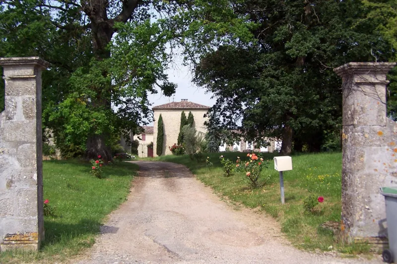
Bonsol Estate House
No reviews yet
Have you flown here? Share your experience with other pilots.
+ Write the first reviewHistory
18e siècle ; 1er quart 19e siècle La maison est connue depuis le 15e siècle. Les bâtiments datent de différentes époques et, au 18e siècle, une aile est ajoutée perpendiculairement au logis et les intérieurs sont réaménagés. Entre 1815 et 1820, un papier peint est posé dans cette aile. Attribué à la manufacture Dufour, il présente des lés identiques bleu turquoise divisés en quatre carrés ornés de faux plis imitant une étoffe. Chaque carré est décoré en son centre d'une couronne de fleurs orange. Les lés sont encadrés d'une frise géométrique de la même couleur orange et séparés les uns des autres par des rideaux verticaux bleus retenus tous les 20cm par un lien orangé. Une bordure haute composée de deux anges encadrant une couronne retenant un rideau décoré de petites fleurs et de pompons, termine la partie supérieure des lés. La partie basse de la même bordure a été posée également dans la partie inférieure des lés le long des lambris. Seuls les anges ont été enlevés et leurs jambes recouvertes d'un papier de teinte marron.
Map and restricted areas
Open in the main mapRestricted zones
| Zone | Category | Limits | Conditions |
|---|---|---|---|
| Zena Perigord High | ZRT | FL 395 / UNL | SUP AIP 062/26 · Du jeudi 23 avril 2026 au jeudi 25 mars 2027 |
Nearby aerodromes
Open aerodromes within 25 km of the spot, heliports included, with their distance and direction from the spot. Near an aerodrome, drone flying is prohibited or height-limited: check the UAS zones map.
| Aerodrome | Type | Distance | Elevation |
|---|---|---|---|
| La Réole Floudes Airport | Aerodrome | 5.1 km S | 13 m |
| Base ULM de Saint Pierre de Bat | Aerodrome | 14 km NW | 48 m |
| Base ULM de Arbis | Aerodrome | 17 km NW | 61 m |
| Bazas Cazats | Aerodrome | 19 km SW | 91 m |
| Marmande-Virazeil Airport | Aerodrome | 25 km SE | 32 m |
Aviation weather (METAR and TAF)
No METAR station within 50 km.
Weather and Kp index
| Day | Weather | Temp. min. / max. | Wind | Rain | Max Kp |
|---|---|---|---|---|---|
| Tue 17 Nov | Rain | 14° / 16° | 31 km/h W | 3.6 mm | 5 |
| Wed 18 Nov | Partly cloudy | 12° / 17° | 27 km/h W | 12 mm | 5 |
| Thu 19 Nov | Heavy rain | 10° / 13° | 35 km/h W | 22 mm | 3 |
| Fri 20 Nov | Showers | 10° / 13° | 27 km/h SW | 14 mm | 3 |
| Sat 21 Nov | Cloudy | 8° / 15° | 17 km/h SE | 5.5 mm | – |
| Sun 22 Nov | Partly cloudy | 11° / 14° | 23 km/h W | 2.2 mm | – |
| Mon 23 Nov | Cloudy | 8° / 15° | 13 km/h SE | – | – |
Hour by hour: Tuesday 17 November
| Time | Weather | Temp. | Wind | Rain | Clouds | Kp |
|---|---|---|---|---|---|---|
| 15:00 | Rain | 15° | 19 km/h SW | 0.8 mm | 100 % | 4 |
| 16:00 | Heavy rain | 14° | 18 km/h SW | 1.7 mm | 100 % | 4 |
| 17:00 | Rain | 14° | 23 km/h W | 0.4 mm | 99 % | 4 |
| 18:00 | Cloudy | 14° | 22 km/h SW | – | 95 % | 4 |
| 19:00 | Partly cloudy | 14° | 24 km/h SW | – | 65 % | 5 |
| 20:00 | Cloudy | 15° | 30 km/h W | – | 99 % | 5 |
| 21:00 | Light rain | 16° | 31 km/h W | 0.1 mm | 100 % | 5 |
| 22:00 | Cloudy | 16° | 30 km/h W | – | 100 % | 5 |
Hour by hour: Wednesday 18 November
| Time | Weather | Temp. | Wind | Rain | Clouds | Kp |
|---|---|---|---|---|---|---|
| 06:00 | Clear sky | 13° | 23 km/h W | – | 3 % | 4 |
| 07:00 | Clear sky | 13° | 24 km/h W | – | 7 % | 4 |
| 08:00 | Clear sky | 12° | 21 km/h W | – | 12 % | 4 |
| 09:00 | Fair | 13° | 23 km/h W | – | 31 % | 4 |
| 10:00 | Showers | 15° | 23 km/h W | 1.0 mm | 42 % | 4 |
| 11:00 | Rain | 14° | 27 km/h W | 0.5 mm | 93 % | 4 |
| 12:00 | Showers | 14° | 22 km/h W | 0.2 mm | 38 % | 4 |
| 13:00 | Partly cloudy | 15° | 25 km/h SW | – | 41 % | 3 |
| 14:00 | Fair | 16° | 24 km/h SW | – | 22 % | 3 |
| 15:00 | Partly cloudy | 17° | 24 km/h W | – | 38 % | 3 |
| 16:00 | Fair | 16° | 22 km/h W | – | 31 % | 3 |
| 17:00 | Clear sky | 15° | 14 km/h SW | – | 3 % | 3 |
| 18:00 | Cloudy | 13° | 9 km/h S | – | 94 % | 3 |
| 19:00 | Cloudy | 13° | 11 km/h SE | – | 100 % | 2 |
| 20:00 | Cloudy | 14° | 17 km/h SE | – | 100 % | 2 |
| 21:00 | Heavy rain | 14° | 21 km/h SE | 1.5 mm | 100 % | 2 |
| 22:00 | Heavy rain | 13° | 18 km/h S | 2.1 mm | 100 % | 2 |
Sunrise and sunset
| Day | Dawn | Sunrise | Golden hour | Sunset | Dusk | Day length |
|---|---|---|---|---|---|---|
| Tue 17 Nov | 07:28 | 08:00 | 08:00–08:44 · 16:46–17:31 | 17:31 | 18:02 | 9 h 31 |
| Wed 18 Nov | 07:29 | 08:01 | 08:01–08:46 · 16:45–17:30 | 17:30 | 18:02 | 9 h 29 |
| Thu 19 Nov | 07:30 | 08:02 | 08:02–08:47 · 16:44–17:29 | 17:29 | 18:01 | 9 h 26 |
| Fri 20 Nov | 07:32 | 08:03 | 08:03–08:49 · 16:43–17:28 | 17:28 | 18:00 | 9 h 24 |
| Sat 21 Nov | 07:33 | 08:05 | 08:05–08:50 · 16:42–17:28 | 17:28 | 17:59 | 9 h 22 |
| Sun 22 Nov | 07:34 | 08:06 | 08:06–08:52 · 16:41–17:27 | 17:27 | 17:59 | 9 h 20 |
| Mon 23 Nov | 07:35 | 08:07 | 08:07–08:53 · 16:40–17:26 | 17:26 | 17:58 | 9 h 18 |

Reviews (0)
Log in to review this spot. Log in · Create a free account
No reviews yet. Share yours!