

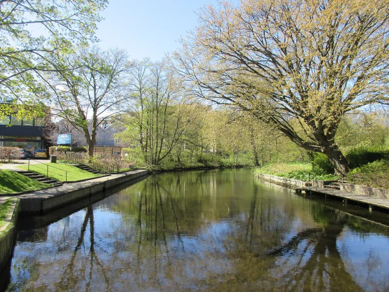
Fæstningskanalen
No reviews yet
Have you flown here? Share your experience with other pilots.
+ Write the first reviewHistory
Fæstningskanalen is a canal in central Kongens Lyngby, in Lyngby-Taarbæk Municipality, Copenhagen. It runs from Lyngby Lake in the west to Lyngby Hovedgade in the east, and its last leg towards Ermelunden no longer holds water. It was part of the fortification ring around the capital, together with the West Rampart (Vestvolden) and coastal fortresses.
Map and restricted areas
Open in the main mapRestricted zones
Nearby aerodromes
Open aerodromes within 25 km of the spot, heliports included, with their distance and direction from the spot. Near an aerodrome, drone flying is prohibited or height-limited: check the UAS zones map.
| Aerodrome | Type | Distance | Elevation |
|---|---|---|---|
| Rigshospitalet Helipad | Heliport | 12 km SE | 9 m |
| København Vandflyveplads | Seaplane base | 13 km SE | 0 m |
| Gørløse Glider Field | Aerodrome | 18 km NW | 14 m |
| Freerslev | Aerodrome | 19 km NW | 20 m |
| Grønholt Hillerød Airfield | Aerodrome | 19 km N | 30 m |
Aviation weather (METAR and TAF)
EKCH – Copenhagen Kastrup Airport VFR
METAR
METAR EKCH 171150Z AUTO 27006KT 9999 OVC032/// 05/02 Q0991 NOSIG
- Wind
- 270°, 11 km/h
- Visibility
- 10 km or more
- Clouds
- Overcast (8/8) at 3,200 ft (980 m)
- Temperature
- 5 °C, dew point 2 °C
- QNH
- 991 hPa
- Flight category
- VFR: ceiling > 3,000 ft and visibility > 5 mi
TAF
TAF EKCH 171127Z 1712/1812 27008KT 9999 BKN030 BECMG 1714/1717 12010KT BECMG 1801/1803 10015G25KT BKN012 TEMPO 1803/1812 09015KT 4000 RA BKN008
| Period (local time) | Change | Wind | Visibility | Weather | Clouds |
|---|---|---|---|---|---|
| 17/11 13:00 → 17/11 15:00 | Initial conditions | 270°, 15 km/h | 10 km or more | Broken (5-7/8) at 3,000 ft (910 m) | |
| 17/11 15:00 → 18/11 02:00 | Becoming | 120°, 19 km/h | 10 km or more | Broken (5-7/8) at 3,000 ft (910 m) | |
| 18/11 02:00 → 18/11 13:00 | Becoming | 100°, 28 km/h, gusts 46 km/h | 10 km or more | Broken (5-7/8) at 1,200 ft (370 m) | |
| 18/11 04:00 → 18/11 13:00 | Temporarily | 090°, 28 km/h | 4.0 km | Rain | Broken (5-7/8) at 800 ft (240 m) |
Weather and Kp index
| Day | Weather | Temp. min. / max. | Wind | Gusts | Rain | Max Kp |
|---|---|---|---|---|---|---|
| Tue 17 Nov | Cloudy | 5° / 6° | 18 km/h E | 37 km/h | – | 5 |
| Wed 18 Nov | Rain | 4° / 6° | 23 km/h E | 47 km/h | 7.3 mm | 5 |
| Thu 19 Nov | Cloudy | 3° / 5° | 14 km/h NW | 28 km/h | – | 3 |
| Fri 20 Nov | Fair | 1° / 5° | 13 km/h W | – | – | 3 |
| Sat 21 Nov | Fair | 2° / 6° | 16 km/h W | – | – | – |
| Sun 22 Nov | Clear sky | 1° / 4° | 11 km/h W | – | – | – |
| Mon 23 Nov | Clear sky | -0° / 2° | 10 km/h N | – | – | – |
Hour by hour: Tuesday 17 November
| Time | Weather | Temp. | Wind | Gusts | Rain | Clouds | Kp |
|---|---|---|---|---|---|---|---|
| 13:00 | Cloudy | 6° | 3 km/h S | 7 km/h | – | 94 % | 4 |
| 14:00 | Cloudy | 6° | 1 km/h S | 8 km/h | – | 96 % | 4 |
| 15:00 | Cloudy | 6° | 5 km/h E | 9 km/h | – | 97 % | 4 |
| 16:00 | Cloudy | 5° | 6 km/h E | 12 km/h | – | 99 % | 4 |
| 17:00 | Cloudy | 5° | 5 km/h E | 12 km/h | – | 100 % | 4 |
| 18:00 | Cloudy | 5° | 7 km/h E | 14 km/h | – | 100 % | 4 |
| 19:00 | Cloudy | 5° | 12 km/h SE | 23 km/h | – | 100 % | 5 |
| 20:00 | Cloudy | 5° | 14 km/h E | 27 km/h | – | 100 % | 5 |
| 21:00 | Cloudy | 5° | 16 km/h E | 31 km/h | – | 100 % | 5 |
| 22:00 | Cloudy | 5° | 18 km/h E | 36 km/h | – | 100 % | 5 |
Hour by hour: Wednesday 18 November
| Time | Weather | Temp. | Wind | Gusts | Rain | Clouds | Kp |
|---|---|---|---|---|---|---|---|
| 06:00 | Light rain | 4° | 23 km/h E | 45 km/h | 0.4 mm | 100 % | 4 |
| 07:00 | Light rain | 5° | 22 km/h E | 47 km/h | 0.4 mm | 100 % | 4 |
| 08:00 | Light rain | 5° | 22 km/h E | 44 km/h | 0.3 mm | 100 % | 4 |
| 09:00 | Rain | 6° | 22 km/h E | 43 km/h | 0.4 mm | 100 % | 4 |
| 10:00 | Light rain | 6° | 21 km/h E | 44 km/h | 0.2 mm | 100 % | 4 |
| 11:00 | Light rain | 6° | 19 km/h E | 41 km/h | 0.3 mm | 100 % | 4 |
| 12:00 | Rain | 6° | 18 km/h E | 38 km/h | 0.5 mm | 100 % | 4 |
| 13:00 | Rain | 6° | 18 km/h E | 36 km/h | 0.5 mm | 100 % | 3 |
| 14:00 | Light rain | 6° | 17 km/h E | 36 km/h | 0.1 mm | 100 % | 3 |
| 15:00 | Light rain | 6° | 17 km/h E | 36 km/h | 0.1 mm | 100 % | 3 |
| 16:00 | Light rain | 6° | 14 km/h NE | 33 km/h | 0.1 mm | 100 % | 3 |
| 17:00 | Cloudy | 5° | 13 km/h NE | 28 km/h | – | 100 % | 3 |
| 18:00 | Cloudy | 5° | 10 km/h NE | 24 km/h | – | 100 % | 3 |
| 19:00 | Cloudy | 5° | 9 km/h N | 19 km/h | – | 100 % | 2 |
| 20:00 | Cloudy | 5° | 10 km/h N | 21 km/h | – | 100 % | 2 |
| 21:00 | Cloudy | 5° | 11 km/h NW | 22 km/h | – | 100 % | 2 |
| 22:00 | Cloudy | 5° | 9 km/h N | 22 km/h | – | 100 % | 2 |
Sunrise and sunset
| Day | Dawn | Sunrise | Golden hour | Sunset | Dusk | Day length |
|---|---|---|---|---|---|---|
| Tue 17 Nov | 07:08 | 07:50 | 07:50–08:54 · 14:56–16:01 | 16:01 | 16:43 | 8 h 10 |
| Wed 18 Nov | 07:09 | 07:52 | 07:52–08:57 · 14:54–15:59 | 15:59 | 16:41 | 8 h 07 |
| Thu 19 Nov | 07:11 | 07:54 | 07:54–08:59 · 14:52–15:57 | 15:57 | 16:40 | 8 h 03 |
| Fri 20 Nov | 07:13 | 07:56 | 07:56–09:02 · 14:50–15:56 | 15:56 | 16:39 | 8 h 00 |
| Sat 21 Nov | 07:15 | 07:58 | 07:58–09:04 · 14:48–15:54 | 15:54 | 16:37 | 7 h 56 |
| Sun 22 Nov | 07:16 | 08:00 | 08:00–09:07 · 14:46–15:53 | 15:53 | 16:36 | 7 h 53 |
| Mon 23 Nov | 07:18 | 08:01 | 08:01–09:09 · 14:44–15:52 | 15:52 | 16:35 | 7 h 50 |
Reviews (0)
Log in to review this spot. Log in · Create a free account
No reviews yet. Share yours!