

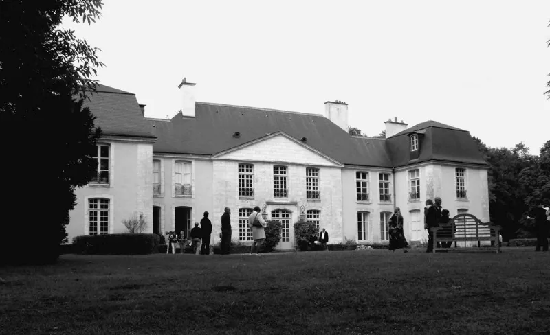
Blosset Castle
No reviews yet
Have you flown here? Share your experience with other pilots.
+ Write the first reviewHistory
Moyen Age ; 2e moitié 18e siècle Le château médiéval de Bourdeilles, restauré au 16e siècle, fut transformé à partir de 1771 en un château moderne pour Paul de Blosset, chevalier de l'ordre de Saint-Louis et ambassadeur. La rénovation fut peut-être confiée à l'ingénieur militaire Züber, dont le nom figure sur la page de garde du recueil des plans du château. L'intérêt de cet ensemble est d'avoir conservé les plans d'origine de la totalité du château, de la basse-cour et du parc. A travers la basse-cour, marquant l'entrée au sud, et constituée de deux ensembles à plan en U, se faisant face de part et d'autre d'une "place" circulaire, partait une chaussée qui empruntait l'ancienne levée du Barangeon pour conduire au château. Des jardins, installés le long de la rivière canalisée, dessinaient un axe est-ouest de part et d'autre du château, implanté au centre de la composition. Au-delà de cette perspective, au nord, s'étendait le parc boisé clos et percé d'allées. La toiture a été détruite par un incendie en 1997.
Map and restricted areas
Open in the main mapRestricted zones
| Zone | Category | Limits | Conditions |
|---|---|---|---|
| Avord | Zone réglementée | 914 m above sea level → 2297 m above sea level | Vols interdits sauf lorsque the official document of the zone l'autorise explicitement ou avec l'accord du gestionnaire de la zone lorsqu'il est désigné par the official document of the zone |
Nearby aerodromes
Open aerodromes within 25 km of the spot, heliports included, with their distance and direction from the spot. Near an aerodrome, drone flying is prohibited or height-limited: check the UAS zones map.
| Aerodrome | Type | Distance | Elevation |
|---|---|---|---|
| Vierzon Méreau Airfield | Aerodrome | 8.3 km W | 131 m |
| Bourges Airport | Airport | 22 km SE | 161 m |
| Centre Hospitalier Heliport | Heliport | 24 km SE | 136 m |
Aviation weather (METAR and TAF)
LFYR – Romorantin Pruniers Airfield VFR
METAR
METAR LFYR 171330Z AUTO 22012KT 170V260 9999 BKN031 BKN038 16/11 Q0996 TEMPO 4000 -RA BECMG 23015G25KT
- Wind
- 220°, 22 km/h
- Visibility
- 10 km or more
- Clouds
- Broken (5-7/8) at 3,100 ft (940 m) ; Broken (5-7/8) at 3,800 ft (1160 m)
- Temperature
- 16 °C, dew point 11 °C
- QNH
- 996 hPa
- Flight category
- VFR: ceiling > 3,000 ft and visibility > 5 mi
TAF
TAF LFYR 170800Z 1709/1809 23015G25KT 9999 BKN020 PROB40 TEMPO 1709/1717 4000 -RA TEMPO 1718/1720 25030G50KT 2000 RA BKN012 BKN020CB PROB40 TEMPO 1803/1809 26025G35KT 4000 SHRA SCT012 BKN020CB
| Period (local time) | Change | Wind | Visibility | Weather | Clouds |
|---|---|---|---|---|---|
| 17/11 10:00 → 18/11 10:00 | Initial conditions | 230°, 28 km/h, gusts 46 km/h | 10 km or more | Broken (5-7/8) at 2,000 ft (610 m) | |
| 17/11 10:00 → 17/11 18:00 | Temporarily, probability 40% | 4.0 km | Rain light | ||
| 17/11 19:00 → 17/11 21:00 | Temporarily | 250°, 56 km/h, gusts 93 km/h | 2.0 km | Rain | Broken (5-7/8) at 1,200 ft (370 m) ; Broken (5-7/8) at 2,000 ft (610 m) (cumulonimbus) |
| 18/11 04:00 → 18/11 10:00 | Temporarily, probability 40% | 260°, 46 km/h, gusts 65 km/h | 4.0 km | Showers of rain | Scattered (3-4/8) at 1,200 ft (370 m) ; Broken (5-7/8) at 2,000 ft (610 m) (cumulonimbus) |
Weather and Kp index
| Day | Weather | Temp. min. / max. | Wind | Rain | Max Kp |
|---|---|---|---|---|---|
| Tue 17 Nov | Cloudy | 12° / 16° | 34 km/h SW | 1.6 mm | 5 |
| Wed 18 Nov | Fair | 10° / 14° | 32 km/h SW | 3.1 mm | 5 |
| Thu 19 Nov | Showers | 9° / 13° | 35 km/h SW | 7.0 mm | 3 |
| Fri 20 Nov | Rain | 9° / 12° | 26 km/h SW | 4.0 mm | 3 |
| Sat 21 Nov | Cloudy | 8° / 12° | 18 km/h SW | 0.1 mm | – |
| Sun 22 Nov | Showers | 8° / 12° | 26 km/h W | 8.6 mm | – |
| Mon 23 Nov | Fair | 6° / 12° | 23 km/h W | 0.2 mm | – |
Hour by hour: Tuesday 17 November
| Time | Weather | Temp. | Wind | Rain | Clouds | Kp |
|---|---|---|---|---|---|---|
| 15:00 | Cloudy | 16° | 30 km/h SW | – | 91 % | 4 |
| 16:00 | Partly cloudy | 16° | 26 km/h SW | – | 47 % | 4 |
| 17:00 | Partly cloudy | 15° | 31 km/h SW | – | 54 % | 4 |
| 18:00 | Cloudy | 14° | 29 km/h SW | – | 98 % | 4 |
| 19:00 | Showers | 14° | 32 km/h SW | 0.8 mm | 56 % | 5 |
| 20:00 | Rain | 12° | 34 km/h SW | 0.5 mm | 99 % | 5 |
| 21:00 | Light rain | 12° | 33 km/h SW | 0.1 mm | 98 % | 5 |
| 22:00 | Showers | 12° | 30 km/h SW | 0.2 mm | 80 % | 5 |
Hour by hour: Wednesday 18 November
| Time | Weather | Temp. | Wind | Rain | Clouds | Kp |
|---|---|---|---|---|---|---|
| 06:00 | Partly cloudy | 11° | 25 km/h SW | – | 57 % | 4 |
| 07:00 | Cloudy | 10° | 26 km/h SW | – | 99 % | 4 |
| 08:00 | Cloudy | 10° | 26 km/h SW | – | 98 % | 4 |
| 09:00 | Cloudy | 10° | 25 km/h SW | – | 95 % | 4 |
| 10:00 | Partly cloudy | 11° | 24 km/h SW | – | 78 % | 4 |
| 11:00 | Showers | 12° | 29 km/h SW | 0.1 mm | 38 % | 4 |
| 12:00 | Showers | 13° | 30 km/h SW | 0.1 mm | 35 % | 4 |
| 13:00 | Fair | 14° | 32 km/h SW | – | 27 % | 3 |
| 14:00 | Showers | 14° | 28 km/h SW | 0.2 mm | 26 % | 3 |
| 15:00 | Fair | 13° | 26 km/h SW | – | 30 % | 3 |
| 16:00 | Partly cloudy | 13° | 25 km/h SW | – | 42 % | 3 |
| 17:00 | Partly cloudy | 12° | 23 km/h SW | – | 73 % | 3 |
| 18:00 | Partly cloudy | 12° | 21 km/h SW | – | 73 % | 3 |
| 19:00 | Cloudy | 11° | 21 km/h SW | – | 95 % | 2 |
| 20:00 | Cloudy | 11° | 21 km/h SW | – | 100 % | 2 |
| 21:00 | Rain | 12° | 20 km/h S | 0.4 mm | 100 % | 2 |
| 22:00 | Rain | 11° | 22 km/h S | 0.7 mm | 100 % | 2 |
Sunrise and sunset
| Day | Dawn | Sunrise | Golden hour | Sunset | Dusk | Day length |
|---|---|---|---|---|---|---|
| Tue 17 Nov | 07:25 | 07:58 | 07:58–08:46 · 16:27–17:14 | 17:14 | 17:48 | 9 h 16 |
| Wed 18 Nov | 07:26 | 08:00 | 08:00–08:47 · 16:25–17:13 | 17:13 | 17:47 | 9 h 13 |
| Thu 19 Nov | 07:27 | 08:01 | 08:01–08:49 · 16:24–17:12 | 17:12 | 17:46 | 9 h 11 |
| Fri 20 Nov | 07:29 | 08:02 | 08:02–08:51 · 16:23–17:11 | 17:11 | 17:45 | 9 h 08 |
| Sat 21 Nov | 07:30 | 08:04 | 08:04–08:52 · 16:22–17:10 | 17:10 | 17:44 | 9 h 06 |
| Sun 22 Nov | 07:31 | 08:05 | 08:05–08:54 · 16:21–17:10 | 17:10 | 17:43 | 9 h 04 |
| Mon 23 Nov | 07:33 | 08:07 | 08:07–08:56 · 16:20–17:09 | 17:09 | 17:43 | 9 h 02 |


Reviews (0)
Log in to review this spot. Log in · Create a free account
No reviews yet. Share yours!