

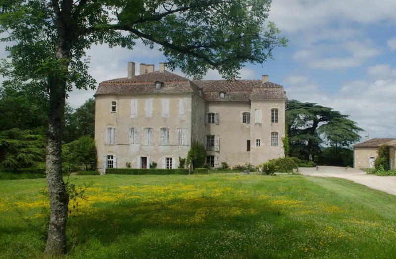
Lacassagne Castle
No reviews yet
Have you flown here? Share your experience with other pilots.
+ Write the first reviewHistory
13e siècle ; 14e siècle ; 17e siècle ; 18e siècle Primitivement, le château devait être une "tour salle" sur laquelle se sont greffés, au cours des siècles, plusieurs éléments architecturaux. Ce noyau central serait la tour ronde abritant l'escalier sur la façade nord-est. Au 17e siècle, l'édifice a été cantonné de deux tours rondes, reliées par un balcon supporté par des corbeaux (sans doute une adjonction du 18e siècle). A l'intérieur, la salle dite des Chevaliers de Malte, de la première moitié 17e siècle, est décorée de lambris, de peintures et d'un plafond peint, reproduisant la salle du grand conseil du palais du Grand Maître à Malte, détruite par Bonaparte en 1798. A l'ouest, une aile d'habitation a été rajoutée au 19e siècle. Les communs délimitant la cour datent de 1850.
Map and restricted areas
Open in the main mapRestricted zones
| Zone | Category | Limits | Conditions |
|---|---|---|---|
| Lectoure Finet (32) | Activité de loisirs | 0 m above ground level → 302 m above ground level · 0 m above ground level → 503 m above sea level | Flights reserved for members and guests of the club, under the terms set by the model-aircraft field manager |
| Voltac Pau Ne | Entrainement Militaire | 0 m above ground level → 15241 m above ground level | Pilotage de drones en vue directe : les aéronefs dont la masse est supérieure à 900 grammes sont soumis à notification préalable selon des modalités publiées sur le site www.ecologie.gouv.fr |
Nearby aerodromes
Open aerodromes within 25 km of the spot, heliports included, with their distance and direction from the spot. Near an aerodrome, drone flying is prohibited or height-limited: check the UAS zones map.
| Aerodrome | Type | Distance | Elevation |
|---|---|---|---|
| Aérodrome de Condom - Valence-sur-Baïse | Aerodrome | 22 km W | 135 m |
| Agen-La Garenne Airport | Airport | 23 km N | 62 m |
Aviation weather (METAR and TAF)
LFBA – Agen-La Garenne Airport IFR
METAR
METAR LFBA 171400Z AUTO 26004KT 230V290 2900 +RA BR SCT006/// BKN012/// OVC019/// ///TCU 14/14 Q1003 TEMPO 3000 RA BKN014 BKN035 FEW060CB
- Wind
- 260°, 7 km/h
- Visibility
- 2.9 km
- Weather
- Rain heavy ; mist
- Clouds
- Scattered (3-4/8) at 600 ft (180 m) ; Broken (5-7/8) at 1,200 ft (370 m) ; Overcast (8/8) at 1,900 ft (580 m)
- Temperature
- 14 °C, dew point 14 °C
- QNH
- 1003 hPa
- Flight category
- IFR: ceiling 500–1,000 ft or visibility 1–3 mi
TAF
TAF AMD LFBA 171415Z 1714/1721 25010KT CAVOK TEMPO 1714/1717 2000 RA SCT005 BKN014 BKN035 FEW060CB TEMPO 1719/1721 3000 RA BKN040TCU
| Period (local time) | Change | Wind | Visibility | Weather | Clouds |
|---|---|---|---|---|---|
| 17/11 15:00 → 17/11 22:00 | Initial conditions | 250°, 19 km/h | 10 km or more | No significant weather | No significant cloud |
| 17/11 15:00 → 17/11 18:00 | Temporarily | 2.0 km | Rain | Scattered (3-4/8) at 500 ft (150 m) ; Broken (5-7/8) at 1,400 ft (430 m) ; Broken (5-7/8) at 3,500 ft (1070 m) | |
| 17/11 20:00 → 17/11 22:00 | Temporarily | 3.0 km | Rain | Broken (5-7/8) at 4,000 ft (1220 m) (towering cumulus) |
Weather and Kp index
Sunrise and sunset
| Day | Dawn | Sunrise | Golden hour | Sunset | Dusk | Day length |
|---|---|---|---|---|---|---|
| Tue 17 Nov | 07:24 | 07:55 | 07:55–08:39 · 16:46–17:30 | 17:30 | 18:01 | 9 h 34 |
| Wed 18 Nov | 07:25 | 07:56 | 07:56–08:40 · 16:45–17:29 | 17:29 | 18:00 | 9 h 32 |
| Thu 19 Nov | 07:26 | 07:57 | 07:57–08:42 · 16:44–17:28 | 17:28 | 17:59 | 9 h 30 |
| Fri 20 Nov | 07:27 | 07:59 | 07:59–08:43 · 16:43–17:27 | 17:27 | 17:59 | 9 h 28 |
| Sat 21 Nov | 07:28 | 08:00 | 08:00–08:45 · 16:42–17:27 | 17:27 | 17:58 | 9 h 26 |
| Sun 22 Nov | 07:30 | 08:01 | 08:01–08:46 · 16:41–17:26 | 17:26 | 17:57 | 9 h 24 |
| Mon 23 Nov | 07:31 | 08:02 | 08:02–08:47 · 16:40–17:25 | 17:25 | 17:57 | 9 h 22 |

Reviews (0)
Log in to review this spot. Log in · Create a free account
No reviews yet. Share yours!