

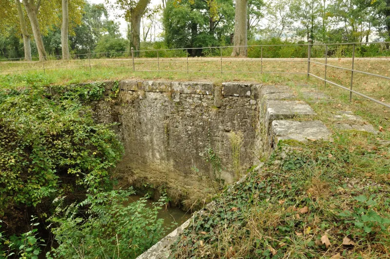
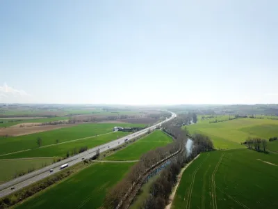
Canal du Midi: Joncasse Aqueduct
No reviews yet
Have you flown here? Share your experience with other pilots.
+ Write the first reviewHistory
2e quart 18e siècle Qualité de la réalisation architecturale et des matériaux employés pour cet aqueduc-siphon du 18e siècle qui permet le passage sous le Canal du Midi des ruisseaux des Rosiers et de la Joncasse. Aqueduc siphon construit en 1734-1735 par la province sur les plans de Clapiès. Ouvrage remarquable par la qualité de sa conception et son exécution, dans laquelle on trouve un des premiers emplois de chaux hydraulique. Il constitue, par ailleurs, un exemple de la compétition qui a mis au prise les ingénieurs du Roi et ceux de la province pour la maîtrise des travaux publics, ce qui s'est traduit par un ouvrage de qualité d'exécution irréprochable. Têtes en parties dégradées, mais maçonneries d'origine.
Map and restricted areas
Open in the main mapRestricted zones
| Zone | Category | Limits | Conditions |
|---|---|---|---|
| Deyme (31) | Activité de loisirs | 0 m above ground level → 152 m above ground level | Flights reserved for members and guests of the club, under the terms set by the model-aircraft field manager |
| Ctr Blagnac |
Zone de contrôle civile | 50 m above ground level → 610 m above sea level | Flights above 50 metres are forbidden without the prior agreement of air traffic control |
| Zrt Lauragais Nord High | ZRT | FL 175 / FL 185 | SUP AIP 055/26 · Du jeudi 16 avril 2026 au mercredi 12 avril 2028 |
| Zrt Lima 1 | ZRT | FL 195 / FL 285 | SUP AIP 219/26 · Du mardi 20 octobre au jeudi 22 octobre 2026 |
Nearby aerodromes
Open aerodromes within 25 km of the spot, heliports included, with their distance and direction from the spot. Near an aerodrome, drone flying is prohibited or height-limited: check the UAS zones map.
| Aerodrome | Type | Distance | Elevation |
|---|---|---|---|
| Toulouse Rangueil Pech David Heliport | Heliport | 11 km NW | 242 m |
| Aérodrome de Toulouse-Lasbordes | Aerodrome | 12 km N | 140 m |
| Toulouse-Francazal (BA 101) Air Base | Airport | 16 km NW | 163 m |
| Centre Hospitalier Régional Heliport | Heliport | 18 km NW | 162 m |
| Renneville Heliport | Heliport | 19 km SE | 190 m |
Aviation weather (METAR and TAF)
LFBO – Toulouse-Blagnac Airport MVFR
METAR
METAR LFBO 171330Z AUTO 03004KT 320V080 9999 OVC024 14/13 Q1004 TEMPO 4000 RA BKN010
- Wind
- 030°, 7 km/h
- Visibility
- 10 km or more
- Clouds
- Overcast (8/8) at 2,400 ft (730 m)
- Temperature
- 14 °C, dew point 13 °C
- QNH
- 1004 hPa
- Flight category
- MVFR: ceiling 1,000–3,000 ft or visibility 3–5 mi
TAF
TAF LFBO 171100Z 1712/1818 18006KT 9999 BKN038 TEMPO 1712/1717 4000 RA BKN010 TEMPO 1717/1720 8000 -RA BKN014 BECMG 1720/1722 CAVOK BECMG 1803/1805 33006KT BECMG 1805/1807 4000 -RA BKN013 BKN040 BECMG 1807/1809 25010KT BECMG 1809/1811 9999 NSW BKN030 BECMG 1816/1818 19006KT CAVOK
| Period (local time) | Change | Wind | Visibility | Weather | Clouds |
|---|---|---|---|---|---|
| 17/11 13:00 → 17/11 21:00 | Initial conditions | 180°, 11 km/h | 10 km or more | Broken (5-7/8) at 3,800 ft (1160 m) | |
| 17/11 13:00 → 17/11 18:00 | Temporarily | 4.0 km | Rain | Broken (5-7/8) at 1,000 ft (300 m) | |
| 17/11 18:00 → 17/11 21:00 | Temporarily | 8 km | Rain light | Broken (5-7/8) at 1,400 ft (430 m) | |
| 17/11 21:00 → 18/11 04:00 | Becoming | 180°, 11 km/h | 10 km or more | No significant weather | No significant cloud |
| 18/11 04:00 → 18/11 06:00 | Becoming | 330°, 11 km/h | 10 km or more | No significant weather | No significant cloud |
| 18/11 06:00 → 18/11 08:00 | Becoming | 330°, 11 km/h | 4.0 km | Rain light | Broken (5-7/8) at 1,300 ft (400 m) ; Broken (5-7/8) at 4,000 ft (1220 m) |
| 18/11 08:00 → 18/11 10:00 | Becoming | 250°, 19 km/h | 4.0 km | Rain light | Broken (5-7/8) at 1,300 ft (400 m) ; Broken (5-7/8) at 4,000 ft (1220 m) |
| 18/11 10:00 → 18/11 17:00 | Becoming | 250°, 19 km/h | 10 km or more | No significant weather | Broken (5-7/8) at 3,000 ft (910 m) |
| 18/11 17:00 → 18/11 19:00 | Becoming | 190°, 11 km/h | 10 km or more | No significant weather | No significant cloud |
Weather and Kp index
| Day | Weather | Temp. min. / max. | Wind | Rain | Max Kp |
|---|---|---|---|---|---|
| Tue 17 Nov | Light rain | 12° / 14° | 12 km/h S | 1.1 mm | 5 |
| Wed 18 Nov | Partly cloudy | 11° / 17° | 26 km/h SE | 3.1 mm | 5 |
| Thu 19 Nov | Fair | 10° / 16° | 29 km/h W | 6.5 mm | 3 |
| Fri 20 Nov | Partly cloudy | 8° / 16° | 17 km/h W | – | 3 |
| Sat 21 Nov | Cloudy | 8° / 16° | 19 km/h SE | 0.1 mm | – |
| Sun 22 Nov | Showers | 11° / 14° | 25 km/h W | 2.2 mm | – |
| Mon 23 Nov | Cloudy | 8° / 14° | 14 km/h W | – | – |
Hour by hour: Tuesday 17 November
| Time | Weather | Temp. | Wind | Rain | Clouds | Kp |
|---|---|---|---|---|---|---|
| 15:00 | Light rain | 14° | 5 km/h E | 0.3 mm | 100 % | 4 |
| 16:00 | Light rain | 14° | 9 km/h NE | 0.1 mm | 99 % | 4 |
| 17:00 | Cloudy | 14° | 8 km/h E | – | 100 % | 4 |
| 18:00 | Cloudy | 13° | 8 km/h SE | – | 100 % | 4 |
| 19:00 | Light rain | 13° | 8 km/h E | 0.3 mm | 100 % | 5 |
| 20:00 | Light rain | 12° | 11 km/h NE | 0.3 mm | 99 % | 5 |
| 21:00 | Light rain | 12° | 10 km/h E | 0.1 mm | 100 % | 5 |
| 22:00 | Cloudy | 12° | 7 km/h SE | – | 100 % | 5 |
Hour by hour: Wednesday 18 November
| Time | Weather | Temp. | Wind | Rain | Clouds | Kp |
|---|---|---|---|---|---|---|
| 06:00 | Light rain | 13° | 16 km/h W | 0.2 mm | 100 % | 4 |
| 07:00 | Light rain | 14° | 20 km/h W | 0.2 mm | 100 % | 4 |
| 08:00 | Rain | 14° | 23 km/h W | 0.4 mm | 100 % | 4 |
| 09:00 | Light rain | 13° | 21 km/h W | 0.2 mm | 100 % | 4 |
| 10:00 | Cloudy | 13° | 20 km/h W | – | 88 % | 4 |
| 11:00 | Cloudy | 14° | 18 km/h SW | – | 99 % | 4 |
| 12:00 | Cloudy | 15° | 18 km/h SW | – | 99 % | 4 |
| 13:00 | Partly cloudy | 16° | 17 km/h W | – | 55 % | 3 |
| 14:00 | Fair | 17° | 18 km/h W | – | 16 % | 3 |
| 15:00 | Partly cloudy | 17° | 16 km/h W | – | 64 % | 3 |
| 16:00 | Partly cloudy | 17° | 11 km/h W | – | 48 % | 3 |
| 17:00 | Partly cloudy | 15° | 3 km/h SW | – | 97 % | 3 |
| 18:00 | Partly cloudy | 13° | 6 km/h S | – | 85 % | 3 |
| 19:00 | Partly cloudy | 12° | 9 km/h S | – | 92 % | 2 |
| 20:00 | Partly cloudy | 13° | 13 km/h SE | – | 95 % | 2 |
| 21:00 | Cloudy | 13° | 18 km/h SE | – | 95 % | 2 |
| 22:00 | Rain | 13° | 24 km/h SE | 0.5 mm | 99 % | 2 |
Sunrise and sunset
| Day | Dawn | Sunrise | Golden hour | Sunset | Dusk | Day length |
|---|---|---|---|---|---|---|
| Tue 17 Nov | 07:19 | 07:50 | 07:50–08:34 · 16:44–17:28 | 17:28 | 17:58 | 9 h 37 |
| Wed 18 Nov | 07:20 | 07:51 | 07:51–08:35 · 16:43–17:27 | 17:27 | 17:58 | 9 h 35 |
| Thu 19 Nov | 07:21 | 07:53 | 07:53–08:36 · 16:42–17:26 | 17:26 | 17:57 | 9 h 33 |
| Fri 20 Nov | 07:23 | 07:54 | 07:54–08:38 · 16:41–17:25 | 17:25 | 17:56 | 9 h 31 |
| Sat 21 Nov | 07:24 | 07:55 | 07:55–08:39 · 16:40–17:24 | 17:24 | 17:56 | 9 h 29 |
| Sun 22 Nov | 07:25 | 07:56 | 07:56–08:41 · 16:39–17:24 | 17:24 | 17:55 | 9 h 27 |
| Mon 23 Nov | 07:26 | 07:57 | 07:57–08:42 · 16:39–17:23 | 17:23 | 17:54 | 9 h 25 |
Reviews (0)
Log in to review this spot. Log in · Create a free account
No reviews yet. Share yours!