

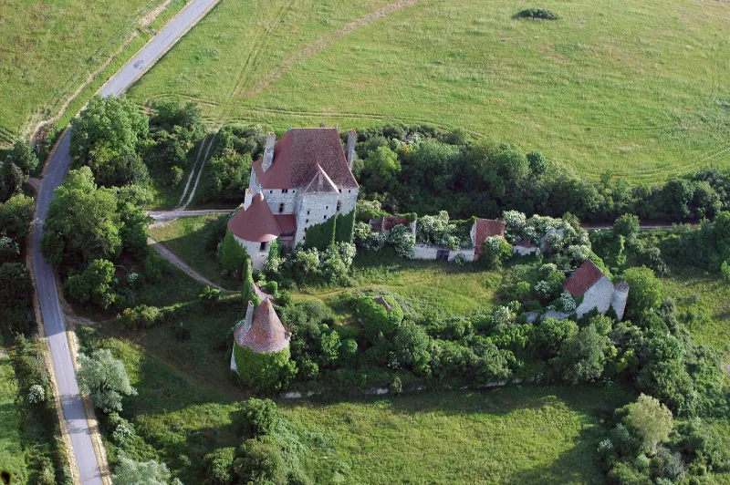
Fourchaud Castle
No reviews yet
Have you flown here? Share your experience with other pilots.
+ Write the first reviewHistory
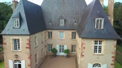
14e siècle ; 15e siècle ; 16e siècle Les constructions sont des 14e et 15e siècles. Au 16e siècle, cet édifice devait être une forteresse comprenant, outre le château, une cour rectangulaire fermée par de hautes courtines dont les angles étaient flanqués de tours rondes. La courtine ouest a conservé la porte d'entrée primitive qui était défendue par un pont-levis. Le corps de logis, accompagné d'une tour, comporte deux étages sur rez-de-chaussée, tous plafonnés. Chaque étage se compose de deux pièces. Les caves sont voûtées. Les pavillons d'avant-corps ont perdu leurs machicoulis. Le château constitue une des forteresses féodales les mieux conservées du Bourbonnais.
Map and restricted areas
Open in the main mapRestricted zones
Nearby aerodromes
Open aerodromes within 25 km of the spot, heliports included, with their distance and direction from the spot. Near an aerodrome, drone flying is prohibited or height-limited: check the UAS zones map.
| Aerodrome | Type | Distance | Elevation |
|---|---|---|---|
| Verneuil en Bourbonnais | Aerodrome | 10 km S | 264 m |
| Centre Hospitalier Heliport | Heliport | 14 km NE | 209 m |
| Aérodrome de Moulins - Montbeugny | Aerodrome | 16 km NE | 279 m |
Aviation weather (METAR and TAF)
LFLV – Vichy-Charmeil Airport VFR
METAR
METAR LFLV 171400Z AUTO 21007KT 140V280 9999 SCT048 SCT056 OVC210 18/10 Q0999
- Wind
- 210°, 13 km/h
- Visibility
- 10 km or more
- Clouds
- Scattered (3-4/8) at 4,800 ft (1460 m) ; Scattered (3-4/8) at 5,600 ft (1710 m) ; Overcast (8/8) at 21,000 ft (6400 m)
- Temperature
- 18 °C, dew point 10 °C
- QNH
- 999 hPa
- Flight category
- VFR: ceiling > 3,000 ft and visibility > 5 mi
TAF
Weather and Kp index
Sunrise and sunset
| Day | Dawn | Sunrise | Golden hour | Sunset | Dusk | Day length |
|---|---|---|---|---|---|---|
| Tue 17 Nov | 07:19 | 07:52 | 07:52–08:38 · 16:26–17:12 | 17:12 | 17:45 | 9 h 20 |
| Wed 18 Nov | 07:20 | 07:53 | 07:53–08:40 · 16:24–17:11 | 17:11 | 17:44 | 9 h 18 |
| Thu 19 Nov | 07:21 | 07:54 | 07:54–08:41 · 16:23–17:10 | 17:10 | 17:43 | 9 h 16 |
| Fri 20 Nov | 07:23 | 07:56 | 07:56–08:43 · 16:22–17:09 | 17:09 | 17:43 | 9 h 13 |
| Sat 21 Nov | 07:24 | 07:57 | 07:57–08:45 · 16:21–17:09 | 17:09 | 17:42 | 9 h 11 |
| Sun 22 Nov | 07:25 | 07:58 | 07:58–08:46 · 16:20–17:08 | 17:08 | 17:41 | 9 h 09 |
| Mon 23 Nov | 07:26 | 08:00 | 08:00–08:48 · 16:19–17:07 | 17:07 | 17:40 | 9 h 07 |
Reviews (0)
Log in to review this spot. Log in · Create a free account
No reviews yet. Share yours!