

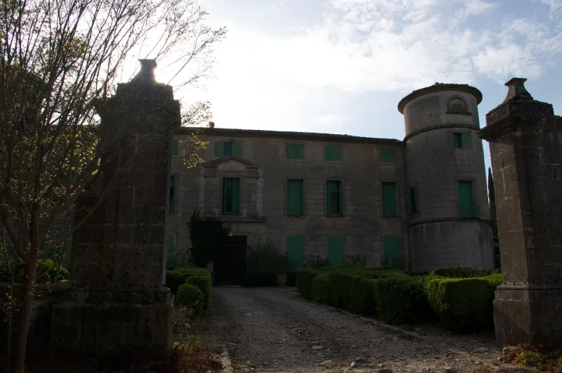
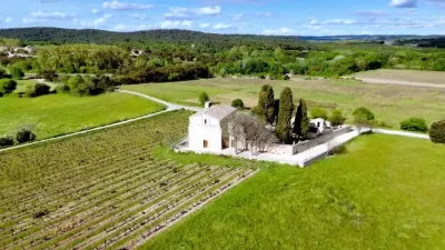
Fesq Castle
No reviews yet
Have you flown here? Share your experience with other pilots.
+ Write the first reviewHistory
17e siècle Plusieurs des éléments se rapportent à la campagne de construction amorcée en 1647 (l'escalier, l'ordonnance de la façade d'entrée avec ses ordres superposés). Le jardin latéral aux allées en croix et la fontaine qui le décore pourraient être des apports du 18e siècle, ainsi que les piliers du grand portail. L'entrée de la cour d'honneur est sans grille, marquée par les deux piliers. La façade principale, flanquée de deux tourelles rondes, s'élève d'un étage et d'un demi-étage sur rez-de-chaussée. L'entrée axiale est marquée par deux ordres superposés, dorique et ionique. A la base, une grande porte rectangulaire, à deux vantaux, est encadrée de pilastres nus. Au-dessus court un entablement : frise à métopes, triglyphes et gouttes, larmier souligné de denticules. La grande fenêtre du premier étage est encadrée de pilastres nus. Le tout est surmonté d'un fronton triangulaire. Les autres fenêtres sont simples. Les tourelles latérales n'ont aucun caractère défensif. Une porte grillée, aménagée au nord de la cour d'honneur, donne accès à un jardin aux allées en croix se recoupant sur un petit rond-point doté d'une vasque. A l'ouest du jardin, au fond de la grande allée, se trouve une fontaine sculptée de feuillages d'eau et de volutes d'où émergent un dauphin et deux aigles.
Map and restricted areas
Open in the main mapRestricted zones
| Zone | Category | Limits | Conditions |
|---|---|---|---|
| Rhone | Zone réglementée | 1067 m above sea level → 6259 m above sea level | Vols interdits sauf lorsque the official document of the zone l'autorise explicitement ou avec l'accord du gestionnaire de la zone lorsqu'il est désigné par the official document of the zone |
| Istres | Zone réglementée | 5491 m above sea level → 30766 m above sea level | Vols interdits sauf lorsque the official document of the zone l'autorise explicitement ou avec l'accord du gestionnaire de la zone lorsqu'il est désigné par the official document of the zone |
| Istres | Zone réglementée | 5491 m above sea level → 30766 m above sea level | Vols interdits sauf lorsque the official document of the zone l'autorise explicitement ou avec l'accord du gestionnaire de la zone lorsqu'il est désigné par the official document of the zone |
| Zrt 108 E4 | ZRT | From about 2,300 m to about 4,400 m above sea level | SUP AIP 232/24 · Du 6 janvier 2025 au 14 avril 2027 |
Nearby aerodromes
Open aerodromes within 25 km of the spot, heliports included, with their distance and direction from the spot. Near an aerodrome, drone flying is prohibited or height-limited: check the UAS zones map.
| Aerodrome | Type | Distance | Elevation |
|---|---|---|---|
| Aérodrome d'Alès Cévennes | Airport | 23 km N | 204 m |
| Aérodrome de Saint-Martin-de-Londres | Aerodrome | 24 km W | 182 m |
Aviation weather (METAR and TAF)
LFTW – Nîmes-Arles-Camargue Airport VFR
METAR
METAR LFTW 171330Z AUTO 17003KT 130V230 CAVOK 14/12 Q1003 TEMPO 4000 SHRA SCT070TCU
- Wind
- 170°, 6 km/h
- Visibility
- 10 km or more
- Clouds
- –
- Temperature
- 14 °C, dew point 12 °C
- QNH
- 1003 hPa
- Flight category
- VFR: ceiling > 3,000 ft and visibility > 5 mi
TAF
TAF LFTW 170800Z 1709/1809 03005KT 9999 SCT013 PROB40 TEMPO 1709/1719 BKN006 PROB40 TEMPO 1711/1717 4000 SHRA SCT070TCU BECMG 1716/1718 23010KT
| Period (local time) | Change | Wind | Visibility | Weather | Clouds |
|---|---|---|---|---|---|
| 17/11 10:00 → 17/11 17:00 | Initial conditions | 030°, 9 km/h | 10 km or more | Scattered (3-4/8) at 1,300 ft (400 m) | |
| 17/11 10:00 → 17/11 20:00 | Temporarily, probability 40% | Broken (5-7/8) at 600 ft (180 m) | |||
| 17/11 12:00 → 17/11 18:00 | Temporarily, probability 40% | 4.0 km | Showers of rain | Scattered (3-4/8) at 7,000 ft (2130 m) (towering cumulus) | |
| 17/11 17:00 → 18/11 10:00 | Becoming | 230°, 19 km/h | 10 km or more | Scattered (3-4/8) at 1,300 ft (400 m) |
Weather and Kp index
| Day | Weather | Temp. min. / max. | Wind | Rain | Max Kp |
|---|---|---|---|---|---|
| Tue 17 Nov | Cloudy | 12° / 16° | 16 km/h S | 2.3 mm | 5 |
| Wed 18 Nov | Clear sky | 11° / 19° | 22 km/h SW | – | 5 |
| Thu 19 Nov | Fair | 11° / 17° | 25 km/h SW | 5.9 mm | 3 |
| Fri 20 Nov | Fair | 11° / 14° | 20 km/h SW | – | 3 |
| Sat 21 Nov | Partly cloudy | 9° / 16° | 14 km/h W | 0.1 mm | – |
| Sun 22 Nov | Fair | 10° / 17° | 13 km/h N | 1.4 mm | – |
| Mon 23 Nov | Cloudy | 9° / 15° | 16 km/h SW | – | – |
Hour by hour: Tuesday 17 November
| Time | Weather | Temp. | Wind | Rain | Clouds | Kp |
|---|---|---|---|---|---|---|
| 15:00 | Cloudy | 16° | 12 km/h SW | – | 99 % | 4 |
| 16:00 | Cloudy | 16° | 16 km/h S | – | 98 % | 4 |
| 17:00 | Cloudy | 15° | 15 km/h SW | – | 100 % | 4 |
| 18:00 | Light rain | 14° | 14 km/h SW | 0.2 mm | 96 % | 4 |
| 19:00 | Heavy rain | 13° | 12 km/h SW | 1.5 mm | 100 % | 5 |
| 20:00 | Light rain | 13° | 9 km/h SW | 0.1 mm | 100 % | 5 |
| 21:00 | Rain | 12° | 8 km/h S | 0.5 mm | 100 % | 5 |
| 22:00 | Cloudy | 13° | 11 km/h S | – | 100 % | 5 |
Hour by hour: Wednesday 18 November
| Time | Weather | Temp. | Wind | Rain | Clouds | Kp |
|---|---|---|---|---|---|---|
| 06:00 | Cloudy | 14° | 18 km/h SW | – | 88 % | 4 |
| 07:00 | Partly cloudy | 14° | 21 km/h SW | – | 67 % | 4 |
| 08:00 | Fair | 14° | 19 km/h SW | – | 37 % | 4 |
| 09:00 | Partly cloudy | 15° | 20 km/h SW | – | 40 % | 4 |
| 10:00 | Partly cloudy | 16° | 19 km/h SW | – | 48 % | 4 |
| 11:00 | Fair | 17° | 22 km/h SW | – | 31 % | 4 |
| 12:00 | Fair | 18° | 19 km/h W | – | 25 % | 4 |
| 13:00 | Clear sky | 18° | 20 km/h W | – | 10 % | 3 |
| 14:00 | Clear sky | 19° | 19 km/h W | – | 4 % | 3 |
| 15:00 | Clear sky | 18° | 18 km/h W | – | 12 % | 3 |
| 16:00 | Clear sky | 17° | 15 km/h SW | – | 5 % | 3 |
| 17:00 | Clear sky | 16° | 14 km/h SW | – | 4 % | 3 |
| 18:00 | Partly cloudy | 14° | 13 km/h SW | – | 52 % | 3 |
| 19:00 | Partly cloudy | 13° | 10 km/h SW | – | 92 % | 2 |
| 20:00 | Partly cloudy | 12° | 12 km/h SW | – | 62 % | 2 |
| 21:00 | Partly cloudy | 12° | 13 km/h SW | – | 98 % | 2 |
| 22:00 | Partly cloudy | 12° | 10 km/h SW | – | 88 % | 2 |
Sunrise and sunset
| Day | Dawn | Sunrise | Golden hour | Sunset | Dusk | Day length |
|---|---|---|---|---|---|---|
| Tue 17 Nov | 07:10 | 07:41 | 07:41–08:25 · 16:33–17:16 | 17:16 | 17:48 | 9 h 35 |
| Wed 18 Nov | 07:11 | 07:42 | 07:42–08:26 · 16:32–17:16 | 17:16 | 17:47 | 9 h 33 |
| Thu 19 Nov | 07:12 | 07:43 | 07:43–08:28 · 16:31–17:15 | 17:15 | 17:46 | 9 h 31 |
| Fri 20 Nov | 07:13 | 07:45 | 07:45–08:29 · 16:30–17:14 | 17:14 | 17:45 | 9 h 29 |
| Sat 21 Nov | 07:15 | 07:46 | 07:46–08:31 · 16:29–17:13 | 17:13 | 17:45 | 9 h 27 |
| Sun 22 Nov | 07:16 | 07:47 | 07:47–08:32 · 16:28–17:12 | 17:12 | 17:44 | 9 h 25 |
| Mon 23 Nov | 07:17 | 07:49 | 07:49–08:33 · 16:27–17:12 | 17:12 | 17:43 | 9 h 23 |
Reviews (0)
Log in to review this spot. Log in · Create a free account
No reviews yet. Share yours!