

Victot Castle
No reviews yet
Have you flown here? Share your experience with other pilots.
+ Write the first reviewHistory
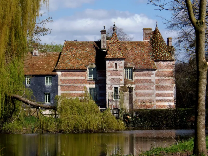
3e quart 13e siècle ; 3e quart 16e siècle ; 1er quart 19e siècle Si Pierre-Alexandre Aumont doit être considéré comme le véritable fondateur de l'écurie de course de Victot, il n'est pas le constructeur des bâtiments des haras de Victot, bâtis en pan de bois. Ces derniers figurent déjà sur le cadastre napoléonien levé en 1812. On doit donc en faire remonter logiquement la construction à son père, Pierre, fournisseur général de la grande Armée, qui acquit Victot en 1798. Il avait déjà consacré sa vie à l'élevage dans les domaines nombreux de Beuvron, Corbon, Thiéville et Victot. La passion chevaline animait la famille d'Aumont depuis le 17e siècle. A sa mort survenue en 1836, Pierre-Alexandre, son fils préféré, reçut en héritage Victot, les autres sites étant partagés entre ses autres enfants. Aussi, nous avons un ensemble qui remonte au tout début du 19e siècle avec quelques modifications intervenues dans les soubassements et des extensions des écuries latéralement qui ne gênent nullement la perception d'ensemble depuis cette grande cour. Lorsque l'on regarde plus en détail ces constructions à un seul niveau, la structure du pan de bois diffère entre l'aile est et l'aile ouest, cette dernière paraissant issue d'une reprise ultérieure. Toutefois, les cartes postales du début du siècle nous les montrent identiques à l'état actuel. L'extension des écuries à l'est modifia simplement les lieux par le percement d'un passage donnant accès aux nouveaux bâtiments. Un seul bâtiment, à l'angle sud-ouest est venu en extension contre le pignon de l'aile ouest. Pour le reste, les bâtiments n'ont guère été modifiés.
Map and restricted areas
Open in the main mapRestricted zones
Nearby aerodromes
Open aerodromes within 25 km of the spot, heliports included, with their distance and direction from the spot. Near an aerodrome, drone flying is prohibited or height-limited: check the UAS zones map.
No known open aerodrome within 25 km.
Aviation weather (METAR and TAF)
LFRG – Deauville-Saint-Gatien Airport VFR
METAR
METAR LFRG 171330Z AUTO 22013KT 190V250 9999 SCT027 OVC031 OVC038 14/10 Q0988 TEMPO 26020G42KT 1400 TSRAGS BKN008 BKN020CB
- Wind
- 220°, 24 km/h
- Visibility
- 10 km or more
- Clouds
- Scattered (3-4/8) at 2,700 ft (820 m) ; Overcast (8/8) at 3,100 ft (940 m) ; Overcast (8/8) at 3,800 ft (1160 m)
- Temperature
- 14 °C, dew point 10 °C
- QNH
- 988 hPa
- Flight category
- VFR: ceiling > 3,000 ft and visibility > 5 mi
TAF
TAF LFRG 171100Z 1712/1721 26020G30KT 9999 BKN030 TEMPO 1712/1721 3000 SHRA BKN012 BKN020TCU SCT025CB TEMPO 1712/1718 26020G42KT PROB40 TEMPO 1713/1718 1400 TSRAGS BKN008 BKN020CB
| Period (local time) | Change | Wind | Visibility | Weather | Clouds |
|---|---|---|---|---|---|
| 17/11 13:00 → 17/11 22:00 | Initial conditions | 260°, 37 km/h, gusts 56 km/h | 10 km or more | Broken (5-7/8) at 3,000 ft (910 m) | |
| 17/11 13:00 → 17/11 22:00 | Temporarily | 3.0 km | Showers of rain | Broken (5-7/8) at 1,200 ft (370 m) ; Broken (5-7/8) at 2,000 ft (610 m) (towering cumulus) ; Scattered (3-4/8) at 2,500 ft (760 m) (cumulonimbus) | |
| 17/11 13:00 → 17/11 19:00 | Temporarily | 260°, 37 km/h, gusts 78 km/h | |||
| 17/11 14:00 → 17/11 19:00 | Temporarily, probability 40% | 1.4 km | Thunderstorm rain ; thunderstorm small hail | Broken (5-7/8) at 800 ft (240 m) ; Broken (5-7/8) at 2,000 ft (610 m) (cumulonimbus) |
Weather and Kp index
| Day | Weather | Temp. min. / max. | Wind | Rain | Max Kp |
|---|---|---|---|---|---|
| Tue 17 Nov | Rain | 10° / 13° | 40 km/h SW | 3.1 mm | 5 |
| Wed 18 Nov | Showers | 10° / 13° | 35 km/h SW | 4.0 mm | 5 |
| Thu 19 Nov | Showers | 8° / 13° | 34 km/h SW | 4.5 mm | 3 |
| Fri 20 Nov | Showers | 9° / 12° | 31 km/h SW | 2.8 mm | 3 |
| Sat 21 Nov | Fair | 6° / 11° | 21 km/h W | 0.1 mm | – |
| Sun 22 Nov | Cloudy | 8° / 11° | 21 km/h SE | 9.9 mm | – |
| Mon 23 Nov | Clear sky | 7° / 11° | 21 km/h W | 0.1 mm | – |
Hour by hour: Tuesday 17 November
| Time | Weather | Temp. | Wind | Rain | Clouds | Kp |
|---|---|---|---|---|---|---|
| 15:00 | Rain | 12° | 32 km/h SW | 0.5 mm | 100 % | 4 |
| 16:00 | Heavy rain | 13° | 36 km/h SW | 1.1 mm | 95 % | 4 |
| 17:00 | Heavy rain | 11° | 40 km/h SW | 1.1 mm | 98 % | 4 |
| 18:00 | Showers | 10° | 37 km/h SW | 0.1 mm | 84 % | 4 |
| 19:00 | Showers | 11° | 34 km/h SW | 0.3 mm | 65 % | 5 |
| 20:00 | Partly cloudy | 11° | 35 km/h SW | – | 53 % | 5 |
| 21:00 | Partly cloudy | 10° | 35 km/h SW | – | 73 % | 5 |
| 22:00 | Partly cloudy | 10° | 36 km/h SW | – | 68 % | 5 |
Hour by hour: Wednesday 18 November
| Time | Weather | Temp. | Wind | Rain | Clouds | Kp |
|---|---|---|---|---|---|---|
| 06:00 | Partly cloudy | 10° | 31 km/h SW | – | 80 % | 4 |
| 07:00 | Partly cloudy | 10° | 30 km/h SW | – | 73 % | 4 |
| 08:00 | Partly cloudy | 10° | 31 km/h SW | – | 66 % | 4 |
| 09:00 | Partly cloudy | 10° | 29 km/h SW | – | 51 % | 4 |
| 10:00 | Partly cloudy | 10° | 28 km/h SW | – | 61 % | 4 |
| 11:00 | Partly cloudy | 12° | 28 km/h SW | – | 66 % | 4 |
| 12:00 | Showers | 12° | 33 km/h SW | 0.2 mm | 57 % | 4 |
| 13:00 | Showers | 13° | 34 km/h SW | 0.2 mm | 41 % | 3 |
| 14:00 | Fair | 13° | 28 km/h SW | – | 23 % | 3 |
| 15:00 | Clear sky | 13° | 28 km/h SW | – | 8 % | 3 |
| 16:00 | Partly cloudy | 13° | 25 km/h SW | – | 45 % | 3 |
| 17:00 | Partly cloudy | 12° | 23 km/h SW | – | 86 % | 3 |
| 18:00 | Cloudy | 11° | 20 km/h SW | – | 97 % | 3 |
| 19:00 | Light rain | 11° | 22 km/h S | 0.4 mm | 99 % | 2 |
| 20:00 | Heavy rain | 11° | 26 km/h S | 1.6 mm | 100 % | 2 |
| 21:00 | Rain | 10° | 27 km/h S | 0.7 mm | 99 % | 2 |
| 22:00 | Light rain | 10° | 26 km/h S | 0.2 mm | 89 % | 2 |
Sunrise and sunset
| Day | Dawn | Sunrise | Golden hour | Sunset | Dusk | Day length |
|---|---|---|---|---|---|---|
| Tue 17 Nov | 07:38 | 08:13 | 08:13–09:04 · 16:26–17:17 | 17:17 | 17:52 | 9 h 03 |
| Wed 18 Nov | 07:40 | 08:15 | 08:15–09:05 · 16:25–17:16 | 17:16 | 17:51 | 9 h 00 |
| Thu 19 Nov | 07:41 | 08:16 | 08:16–09:07 · 16:24–17:15 | 17:15 | 17:50 | 8 h 58 |
| Fri 20 Nov | 07:43 | 08:18 | 08:18–09:09 · 16:22–17:14 | 17:14 | 17:49 | 8 h 55 |
| Sat 21 Nov | 07:44 | 08:19 | 08:19–09:11 · 16:21–17:13 | 17:13 | 17:48 | 8 h 53 |
| Sun 22 Nov | 07:45 | 08:21 | 08:21–09:12 · 16:20–17:12 | 17:12 | 17:47 | 8 h 50 |
| Mon 23 Nov | 07:47 | 08:22 | 08:22–09:14 · 16:19–17:11 | 17:11 | 17:46 | 8 h 48 |

Reviews (0)
Log in to review this spot. Log in · Create a free account
No reviews yet. Share yours!