

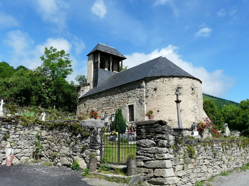
Saint-Geniès de Benque-Dessous Church
No reviews yet
Have you flown here? Share your experience with other pilots.
+ Write the first reviewHistory
12e siècle ; 17e siècle Eglise romane, remaniée au 17e siècle. L'édifice comporte une nef et une abside semi-circulaire voûtée en cul-de-four. Des cippes funéraires gallo-romaines sont réemployées dans la chaîne d'angle sud-ouest. L'élévation sud est percée d'un portail dont le tympan est orné d'un chrisme en bas-relief. Intérieurement, la nef est lambrissée avec une voûte en arc polygonal, résultat d'une restauration du 19e siècle, travaux qui ont également touché le décor peint, afin d'uniformiser les anciennes peintures murales et le nouveau décor. Ces peintures ont été conservées sans repeint au cul-de-four avec la colombe de l'Esprit dans une nuée, et deux grands anges musiciens. Les murs latéraux de l'abside sont traités en trompe l'oeil à la façon d'un retable.
Map and restricted areas
Open in the main mapRestricted zones
Nearby aerodromes
Open aerodromes within 25 km of the spot, heliports included, with their distance and direction from the spot. Near an aerodrome, drone flying is prohibited or height-limited: check the UAS zones map.
| Aerodrome | Type | Distance | Elevation |
|---|---|---|---|
| Altisurface de Cap De Pouy | Aerodrome | 3.5 km S | 1,800 m |
| Aérodrome de Bagnères de Luchon | Aerodrome | 4.1 km SE | 618 m |
| Altisurface de Honteyde | Aerodrome | 4.9 km NW | 1,900 m |
| Altisurface de Cap De Barres | Aerodrome | 6.2 km NW | 1,767 m |
| Pene De Soulit Altisurface | Aerodrome | 7.9 km W | 1,940 m |
Aviation weather (METAR and TAF)
No METAR station within 50 km.
Weather and Kp index
Sunrise and sunset
| Day | Dawn | Sunrise | Golden hour | Sunset | Dusk | Day length |
|---|---|---|---|---|---|---|
| Tue 17 Nov | 07:22 | 07:52 | 07:52–08:35 · 16:50–17:33 | 17:33 | 18:04 | 9 h 41 |
| Wed 18 Nov | 07:23 | 07:53 | 07:53–08:36 · 16:49–17:32 | 17:32 | 18:03 | 9 h 39 |
| Thu 19 Nov | 07:24 | 07:55 | 07:55–08:38 · 16:49–17:32 | 17:32 | 18:02 | 9 h 36 |
| Fri 20 Nov | 07:25 | 07:56 | 07:56–08:39 · 16:48–17:31 | 17:31 | 18:02 | 9 h 34 |
| Sat 21 Nov | 07:26 | 07:57 | 07:57–08:41 · 16:47–17:30 | 17:30 | 18:01 | 9 h 33 |
| Sun 22 Nov | 07:27 | 07:58 | 07:58–08:42 · 16:46–17:29 | 17:29 | 18:00 | 9 h 31 |
| Mon 23 Nov | 07:29 | 08:00 | 08:00–08:43 · 16:45–17:29 | 17:29 | 18:00 | 9 h 29 |

Reviews (0)
Log in to review this spot. Log in · Create a free account
No reviews yet. Share yours!