

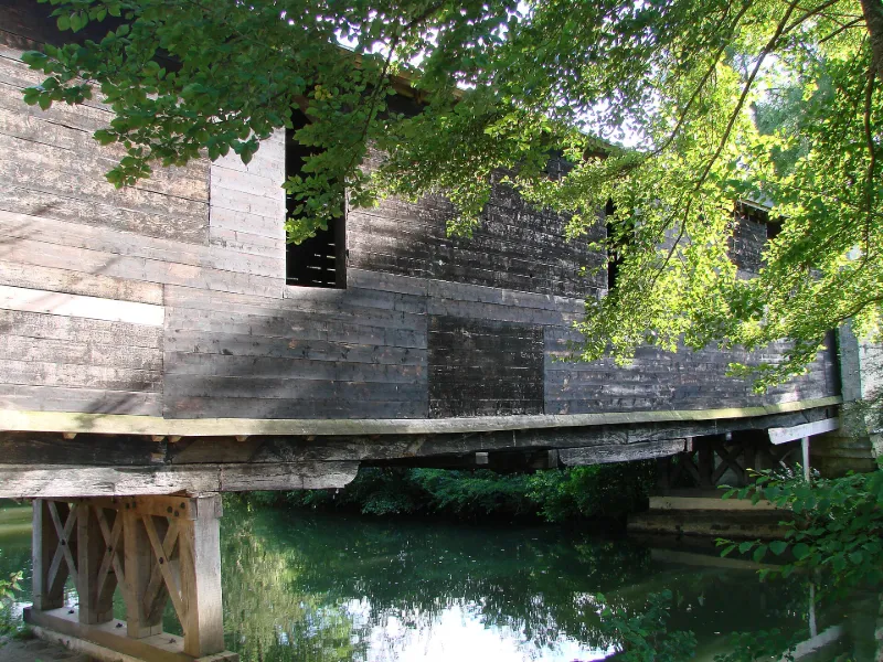
Wooden Covered Bridge
No reviews yet
Have you flown here? Share your experience with other pilots.
+ Write the first reviewHistory
19e siècle L'ouvrage pourrait dater du milieu du 19e siècle. Selon la version locale, il aurait été bâti par les entreprises qui travaillaient sur le chemin du viaduc des Roches, élevé entre 1847 et 1854 lors de la construction du tronçon Châteauroux/Argenton-sur-Creuse du chemin de fer du Centre, suite à la noyade de plusieurs ouvriers. Selon une autre version, le pont aurait été construit vers 1860 par le comte de Foix pour desservir ses domaines. Ce pont doit être, en France, le seul ouvrage en bois entièrement couvert.£Deux culées de pierre reçoivent les appuis du pont. La structure porteuse consiste en deux poutres triangulées, reposant sur des palées de bois. Le tablier est bordé par deux parois formées de planches jointives, percées d'orifices circulaires. Les assemblages de bois sont réalisés soit à l'ancienne, soit par simple boulonnage. Des tirants ont été ajoutés pour assurer les contreventements. De chaque côté, le pont se termine par des avant-corps en maçonnerie qui prolongent en élévation les culées.
Map and restricted areas
Open in the main mapRestricted zones
| Zone | Category | Limits | Conditions |
|---|---|---|---|
| Tours Cinq Mars la Pile | Zone réglementée | 3053 m above sea level → 6259 m above sea level | Vols interdits sauf lorsque the official document of the zone l'autorise explicitement ou avec l'accord du gestionnaire de la zone lorsqu'il est désigné par the official document of the zone |
Nearby aerodromes
Open aerodromes within 25 km of the spot, heliports included, with their distance and direction from the spot. Near an aerodrome, drone flying is prohibited or height-limited: check the UAS zones map.
| Aerodrome | Type | Distance | Elevation |
|---|---|---|---|
| Argenton Sur Creuse Airfield | Aerodrome | 7.6 km SE | 202 m |
| Centre Hospitalier Heliport | Heliport | 23 km NE | 170 m |
| Châteauroux Villers Airfield | Aerodrome | 25 km N | 165 m |
Aviation weather (METAR and TAF)
LFLX – Châteauroux-Déols "Marcel Dassault" Airport VFR
METAR
METAR LFLX 171400Z AUTO 22025KT 9999 SCT037 BKN045 BKN052 17/11 Q0997 BECMG 22020G30KT
- Wind
- 220°, 46 km/h
- Visibility
- 10 km or more
- Clouds
- Scattered (3-4/8) at 3,700 ft (1130 m) ; Broken (5-7/8) at 4,500 ft (1370 m) ; Broken (5-7/8) at 5,200 ft (1580 m)
- Temperature
- 17 °C, dew point 11 °C
- QNH
- 997 hPa
- Flight category
- VFR: ceiling > 3,000 ft and visibility > 5 mi
TAF
TAF LFLX 171100Z 1712/1818 22020G30KT 9999 BKN025 TEMPO 1717/1721 2500 SHRA BKN015CB PROB30 TEMPO 1719/1721 25025G45KT BECMG 1721/1723 24015KT PROB40 TEMPO 1805/1816 24020G30KT PROB30 TEMPO 1805/1810 3000 -TSRA BKN015CB
| Period (local time) | Change | Wind | Visibility | Weather | Clouds |
|---|---|---|---|---|---|
| 17/11 13:00 → 17/11 22:00 | Initial conditions | 220°, 37 km/h, gusts 56 km/h | 10 km or more | Broken (5-7/8) at 2,500 ft (760 m) | |
| 17/11 18:00 → 17/11 22:00 | Temporarily | 2.5 km | Showers of rain | Broken (5-7/8) at 1,500 ft (460 m) (cumulonimbus) | |
| 17/11 20:00 → 17/11 22:00 | Temporarily, probability 30% | 250°, 46 km/h, gusts 83 km/h | |||
| 17/11 22:00 → 18/11 19:00 | Becoming | 240°, 28 km/h | 10 km or more | Broken (5-7/8) at 2,500 ft (760 m) | |
| 18/11 06:00 → 18/11 17:00 | Temporarily, probability 40% | 240°, 37 km/h, gusts 56 km/h | |||
| 18/11 06:00 → 18/11 11:00 | Temporarily, probability 30% | 3.0 km | Thunderstorm rain light | Broken (5-7/8) at 1,500 ft (460 m) (cumulonimbus) |
Weather and Kp index
Sunrise and sunset
| Day | Dawn | Sunrise | Golden hour | Sunset | Dusk | Day length |
|---|---|---|---|---|---|---|
| Tue 17 Nov | 07:26 | 07:59 | 07:59–08:46 · 16:32–17:19 | 17:19 | 17:52 | 9 h 19 |
| Wed 18 Nov | 07:27 | 08:00 | 08:00–08:48 · 16:31–17:18 | 17:18 | 17:51 | 9 h 17 |
| Thu 19 Nov | 07:29 | 08:02 | 08:02–08:49 · 16:29–17:17 | 17:17 | 17:50 | 9 h 14 |
| Fri 20 Nov | 07:30 | 08:03 | 08:03–08:51 · 16:28–17:16 | 17:16 | 17:49 | 9 h 12 |
| Sat 21 Nov | 07:31 | 08:05 | 08:05–08:52 · 16:27–17:15 | 17:15 | 17:48 | 9 h 10 |
| Sun 22 Nov | 07:33 | 08:06 | 08:06–08:54 · 16:26–17:14 | 17:14 | 17:48 | 9 h 08 |
| Mon 23 Nov | 07:34 | 08:07 | 08:07–08:55 · 16:25–17:13 | 17:13 | 17:47 | 9 h 06 |

Reviews (0)
Log in to review this spot. Log in · Create a free account
No reviews yet. Share yours!