

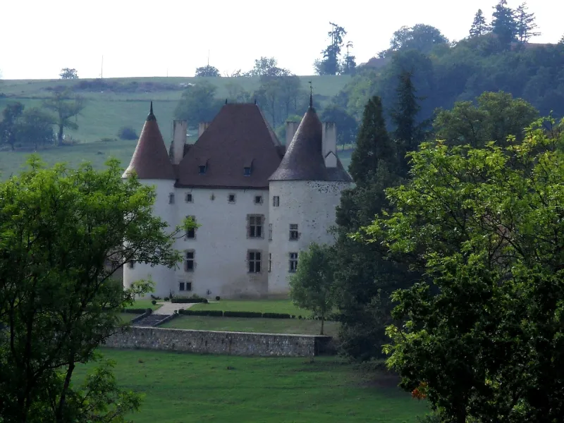
Verseilles Castle
No reviews yet
Have you flown here? Share your experience with other pilots.
+ Write the first reviewHistory
15e siècle ; 17e siècle Construit au milieu du 15e siècle, le château se présente comme une maison forte dont les dispositions architecturales n'ont pas subi de modifications notables, hormis quelques percements du 16e siècle. Il se compose d'un logis rectangulaire flanqué de deux tours d'angle et d'une tourelle d'escalier demi hors-oeuvre. A l'intérieur, un ensemble de pièces ont conservé leurs cheminées gothiques, leurs plafonds à la française, leurs sols en tomettes et leurs portes à plis de serviette. Des restes de peintures murales du 17e siècle décorent certaines pièces du premier étage. Une embrasure de fenêtre du second étage contient un dessin gravé, sans doute du 16e siècle, représentant un personnage en pied.
Map and restricted areas
Open in the main mapRestricted zones
Nearby aerodromes
Open aerodromes within 25 km of the spot, heliports included, with their distance and direction from the spot. Near an aerodrome, drone flying is prohibited or height-limited: check the UAS zones map.
| Aerodrome | Type | Distance | Elevation |
|---|---|---|---|
| Vichy-Charmeil Airport | Airport | 10 km W | 249 m |
| Lapalisse - Périgny Airfield | Aerodrome | 12 km N | 317 m |
Aviation weather (METAR and TAF)
LFLV – Vichy-Charmeil Airport VFR
METAR
METAR LFLV 171400Z AUTO 21007KT 140V280 9999 SCT048 SCT056 OVC210 18/10 Q0999
- Wind
- 210°, 13 km/h
- Visibility
- 10 km or more
- Clouds
- Scattered (3-4/8) at 4,800 ft (1460 m) ; Scattered (3-4/8) at 5,600 ft (1710 m) ; Overcast (8/8) at 21,000 ft (6400 m)
- Temperature
- 18 °C, dew point 10 °C
- QNH
- 999 hPa
- Flight category
- VFR: ceiling > 3,000 ft and visibility > 5 mi
TAF
Weather and Kp index
Sunrise and sunset
| Day | Dawn | Sunrise | Golden hour | Sunset | Dusk | Day length |
|---|---|---|---|---|---|---|
| Tue 17 Nov | 07:17 | 07:50 | 07:50–08:36 · 16:26–17:12 | 17:12 | 17:45 | 9 h 22 |
| Wed 18 Nov | 07:18 | 07:51 | 07:51–08:37 · 16:25–17:11 | 17:11 | 17:44 | 9 h 20 |
| Thu 19 Nov | 07:19 | 07:52 | 07:52–08:39 · 16:23–17:10 | 17:10 | 17:43 | 9 h 17 |
| Fri 20 Nov | 07:21 | 07:54 | 07:54–08:41 · 16:22–17:09 | 17:09 | 17:42 | 9 h 15 |
| Sat 21 Nov | 07:22 | 07:55 | 07:55–08:42 · 16:21–17:08 | 17:08 | 17:41 | 9 h 13 |
| Sun 22 Nov | 07:23 | 07:56 | 07:56–08:44 · 16:20–17:08 | 17:08 | 17:41 | 9 h 11 |
| Mon 23 Nov | 07:25 | 07:58 | 07:58–08:45 · 16:19–17:07 | 17:07 | 17:40 | 9 h 09 |
Reviews (0)
Log in to review this spot. Log in · Create a free account
No reviews yet. Share yours!