

Tourist site
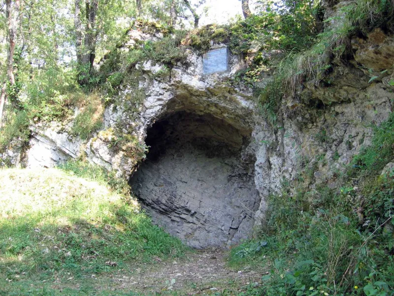
Prehistoric Cave
No reviews yet
Have you flown here? Share your experience with other pilots.
+ Write the first reviewHistory
Préhistoire ; Paléolithique supérieur
Map and restricted areas
Open in the main mapRestricted zones
| Zone | Category | Limits | Conditions |
|---|---|---|---|
| Voltac Pau Ne | Entrainement Militaire | 0 m above ground level → 15241 m above ground level | Pilotage de drones en vue directe : les aéronefs dont la masse est supérieure à 900 grammes sont soumis à notification préalable selon des modalités publiées sur le site www.ecologie.gouv.fr |
| R 46 F3 | Zone réglementée | 244 m above ground level → 1006 m above sea level | Vols interdits sauf lorsque the official document of the zone l'autorise explicitement ou avec l'accord du gestionnaire de la zone lorsqu'il est désigné par the official document of the zone |
| Zrt Lima 1 | ZRT | FL 195 / FL 285 | SUP AIP 219/26 · Du mardi 20 octobre au jeudi 22 octobre 2026 |
Nearby aerodromes
Open aerodromes within 25 km of the spot, heliports included, with their distance and direction from the spot. Near an aerodrome, drone flying is prohibited or height-limited: check the UAS zones map.
| Aerodrome | Type | Distance | Elevation |
|---|---|---|---|
| Altisurface de Balesta Nature | Aerodrome | 13 km SE | 425 m |
| Aérodrome de Cazères - Palaminy | Aerodrome | 15 km E | 247 m |
| Base ULM du Fousseret | Aerodrome | 16 km E | 250 m |
| Aérodrome de L'Isle-en-Dodon | Aerodrome | 18 km N | 280 m |
| Cérizols Balloonport | Balloon port | 20 km SE | 400 m |
Aviation weather (METAR and TAF)
No METAR station within 50 km.
Weather and Kp index
| Day | Weather | Temp. min. / max. | Wind | Rain | Max Kp |
|---|---|---|---|---|---|
| Tue 17 Nov | Cloudy | 11° / 14° | 15 km/h N | – | 5 |
| Wed 18 Nov | Clear sky | 11° / 17° | 24 km/h W | 2.2 mm | 5 |
| Thu 19 Nov | Clear sky | 8° / 16° | 35 km/h NW | 5.9 mm | 3 |
| Fri 20 Nov | Partly cloudy | 4° / 16° | 21 km/h W | – | 3 |
| Sat 21 Nov | Cloudy | 6° / 16° | 13 km/h E | 0.2 mm | – |
| Sun 22 Nov | Partly cloudy | 10° / 14° | 30 km/h W | 1.9 mm | – |
| Mon 23 Nov | Cloudy | 4° / 14° | 12 km/h W | – | – |
Hour by hour: Tuesday 17 November
| Time | Weather | Temp. | Wind | Rain | Clouds | Kp |
|---|---|---|---|---|---|---|
| 15:00 | Cloudy | 14° | 8 km/h NE | – | 100 % | 4 |
| 16:00 | Cloudy | 14° | 12 km/h E | – | 100 % | 4 |
| 17:00 | Cloudy | 13° | 8 km/h SE | – | 100 % | 4 |
| 18:00 | Cloudy | 13° | 11 km/h S | – | 100 % | 4 |
| 19:00 | Cloudy | 12° | 10 km/h SE | – | 99 % | 5 |
| 20:00 | Cloudy | 12° | 15 km/h N | – | 100 % | 5 |
| 21:00 | Fog | 12° | 6 km/h SE | – | 100 % | 5 |
| 22:00 | Fog | 12° | 9 km/h S | – | 99 % | 5 |
Hour by hour: Wednesday 18 November
| Time | Weather | Temp. | Wind | Rain | Clouds | Kp |
|---|---|---|---|---|---|---|
| 06:00 | Light rain | 12° | 19 km/h NW | 0.2 mm | 100 % | 4 |
| 07:00 | Light rain | 12° | 24 km/h W | 0.4 mm | 100 % | 4 |
| 08:00 | Rain | 12° | 24 km/h W | 0.4 mm | 98 % | 4 |
| 09:00 | Showers | 12° | 22 km/h W | 0.1 mm | 80 % | 4 |
| 10:00 | Partly cloudy | 12° | 21 km/h W | – | 70 % | 4 |
| 11:00 | Fair | 14° | 17 km/h W | – | 33 % | 4 |
| 12:00 | Clear sky | 15° | 17 km/h W | – | 6 % | 4 |
| 13:00 | Clear sky | 16° | 18 km/h W | – | 6 % | 3 |
| 14:00 | Clear sky | 17° | 15 km/h W | – | 5 % | 3 |
| 15:00 | Partly cloudy | 17° | 13 km/h W | – | 79 % | 3 |
| 16:00 | Partly cloudy | 16° | 9 km/h W | – | 39 % | 3 |
| 17:00 | Partly cloudy | 15° | 3 km/h E | – | 84 % | 3 |
| 18:00 | Partly cloudy | 12° | 6 km/h E | – | 84 % | 3 |
| 19:00 | Partly cloudy | 12° | 12 km/h SE | – | 99 % | 2 |
| 20:00 | Cloudy | 13° | 17 km/h SE | – | 89 % | 2 |
| 21:00 | Cloudy | 12° | 19 km/h SE | – | 98 % | 2 |
| 22:00 | Light rain | 12° | 17 km/h E | 0.2 mm | 100 % | 2 |
Sunrise and sunset
| Day | Dawn | Sunrise | Golden hour | Sunset | Dusk | Day length |
|---|---|---|---|---|---|---|
| Tue 17 Nov | 07:21 | 07:52 | 07:52–08:35 · 16:48–17:31 | 17:31 | 18:02 | 9 h 38 |
| Wed 18 Nov | 07:22 | 07:53 | 07:53–08:37 · 16:47–17:30 | 17:30 | 18:01 | 9 h 36 |
| Thu 19 Nov | 07:24 | 07:55 | 07:55–08:38 · 16:46–17:29 | 17:29 | 18:00 | 9 h 34 |
| Fri 20 Nov | 07:25 | 07:56 | 07:56–08:39 · 16:45–17:29 | 17:29 | 18:00 | 9 h 32 |
| Sat 21 Nov | 07:26 | 07:57 | 07:57–08:41 · 16:44–17:28 | 17:28 | 17:59 | 9 h 30 |
| Sun 22 Nov | 07:27 | 07:58 | 07:58–08:42 · 16:43–17:27 | 17:27 | 17:58 | 9 h 28 |
| Mon 23 Nov | 07:28 | 07:59 | 07:59–08:44 · 16:42–17:26 | 17:26 | 17:58 | 9 h 26 |

Reviews (0)
Log in to review this spot. Log in · Create a free account
No reviews yet. Share yours!