

Vallade Manor House
No reviews yet
Have you flown here? Share your experience with other pilots.
+ Write the first reviewHistory
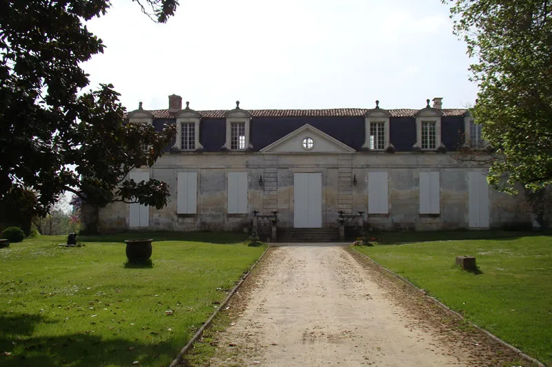
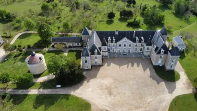
2e quart 18e siècle La famille Vallade est pointée dans les registres paroissiaux du début du 17e siècle. La maison noble a été construite en 1746, probablement à l'emplacement d'un logis plus ancien. Le domaine se trouvait au centre d'une parcelle rayonnant autour du logis de plan rectangulaire. Des servitudes en U fermaient une cour au devant. Actuellement, le logis a été amputé de sa partie nord. Il ne reste plus qu'une aile nord de communs, qui ont été agrandis. Le corps de logis en pierre de taille se développe sur un niveau recouvert d'un comble éclairé de lucarnes à frontons cintrés. La porte axiale est encadrée de pilastres à bossages en table, supportant un fronton triangulaire. La façade sur jardin présente cinq lucarnes sous fronton triangulaire. Un pavillon en saillie termine le logis au nord et renferme un vaste escalier en pierre à balustres qui paraît remonter au 17e siècle (vestige d'un édifice antérieur ou réemploi). L'aménagement intérieur du logis date pour l'essentiel du 19e siècle. Le style de Vallade, oeuvre du 18e siècle, se rapproche bien plus des exemples connus de l'architecture classique du 17e siècle. Il faut y voir une demeure modeste, pérennisant un style correspondant au goût de la petite noblesse soucieuse de se retirer dans ses terres et de les gérer.
Map and restricted areas
Open in the main mapRestricted zones
| Zone | Category | Limits | Conditions |
|---|---|---|---|
| Tma la Rochelle |
Région de contrôle terminal | 610 m above sea level → 914 m above sea level · 610 m above sea level → 914 m above sea level · 610 m above sea level → 3821 m above sea level · 610 m above sea level → 3821 m above sea level · 914 m above sea level → 3821 m above sea level | Drone flights inside this zone are forbidden without the prior agreement of air traffic control |
| Cognac | Zone réglementée | 914 m above sea level → 1219 m above sea level | Vols interdits sauf lorsque the official document of the zone l'autorise explicitement ou avec l'accord du gestionnaire de la zone lorsqu'il est désigné par the official document of the zone |
| Cognac | Zone réglementée | 1219 m above sea level → 2297 m above sea level | Vols interdits sauf lorsque the official document of the zone l'autorise explicitement ou avec l'accord du gestionnaire de la zone lorsqu'il est désigné par the official document of the zone |
| Cognac | Zone réglementée | 1529 m above sea level → 6259 m above sea level | Vols interdits sauf lorsque the official document of the zone l'autorise explicitement ou avec l'accord du gestionnaire de la zone lorsqu'il est désigné par the official document of the zone |
| Bordeaux | Zone réglementée | 5491 m above sea level → 30766 m above sea level | Vols interdits sauf lorsque the official document of the zone l'autorise explicitement ou avec l'accord du gestionnaire de la zone lorsqu'il est désigné par the official document of the zone |
| Zena Gascogne | Zone dangereuse | 5491 m above sea level → 30766 m above sea level | Vols interdits sauf lorsque the official document of the zone l'autorise explicitement ou avec l'accord du gestionnaire de la zone lorsqu'il est désigné par the official document of the zone |
| Zena Gascogne Restreinte | Zone dangereuse | 5491 m above sea level → 30766 m above sea level | Vols interdits sauf lorsque the official document of the zone l'autorise explicitement ou avec l'accord du gestionnaire de la zone lorsqu'il est désigné par the official document of the zone |
Nearby aerodromes
Open aerodromes within 25 km of the spot, heliports included, with their distance and direction from the spot. Near an aerodrome, drone flying is prohibited or height-limited: check the UAS zones map.
| Aerodrome | Type | Distance | Elevation |
|---|---|---|---|
| Saintes Thénac Airfield | Aerodrome | 5.9 km E | 36 m |
| Centre Hospitalier de Saintongues Heliport | Heliport | 7.2 km NE | 41 m |
| Pons Avy Airfield | Aerodrome | 21 km SE | 36 m |
| Royan-Médis Airport | Airport | 22 km W | 22 m |
| Base ULM Vol d'oiseau | Aerodrome | 23 km W | 15 m |
Aviation weather (METAR and TAF)
LFBG – Cognac-Châteaubernard (BA 709) Air Base VFR
METAR
METAR LFBG 171330Z AUTO 23016KT 9999 SCT025 BKN031 BKN038 18/13 Q1000 TEMPO 4000 SHRA SCT030TCU BECMG 25018G28KT
- Wind
- 230°, 30 km/h
- Visibility
- 10 km or more
- Clouds
- Scattered (3-4/8) at 2,500 ft (760 m) ; Broken (5-7/8) at 3,100 ft (940 m) ; Broken (5-7/8) at 3,800 ft (1160 m)
- Temperature
- 18 °C, dew point 13 °C
- QNH
- 1000 hPa
- Flight category
- VFR: ceiling > 3,000 ft and visibility > 5 mi
TAF
TAF LFBG 170800Z 1709/1809 25018G28KT 9999 BKN020 PROB30 TEMPO 1715/1718 4000 SHRA SCT030TCU TEMPO 1719/1723 24025G35KT 4000 SHRA BKN030TCU PROB40 TEMPO 1720/1722 3000 TSRA BKN025CB TEMPO 1806/1809 4000 SHRA BKN020TCU
| Period (local time) | Change | Wind | Visibility | Weather | Clouds |
|---|---|---|---|---|---|
| 17/11 10:00 → 18/11 10:00 | Initial conditions | 250°, 33 km/h, gusts 52 km/h | 10 km or more | Broken (5-7/8) at 2,000 ft (610 m) | |
| 17/11 16:00 → 17/11 19:00 | Temporarily, probability 30% | 4.0 km | Showers of rain | Scattered (3-4/8) at 3,000 ft (910 m) (towering cumulus) | |
| 17/11 20:00 → 18/11 00:00 | Temporarily | 240°, 46 km/h, gusts 65 km/h | 4.0 km | Showers of rain | Broken (5-7/8) at 3,000 ft (910 m) (towering cumulus) |
| 17/11 21:00 → 17/11 23:00 | Temporarily, probability 40% | 3.0 km | Thunderstorm rain | Broken (5-7/8) at 2,500 ft (760 m) (cumulonimbus) | |
| 18/11 07:00 → 18/11 10:00 | Temporarily | 4.0 km | Showers of rain | Broken (5-7/8) at 2,000 ft (610 m) (towering cumulus) |
Weather and Kp index
| Day | Weather | Temp. min. / max. | Wind | Rain | Max Kp |
|---|---|---|---|---|---|
| Tue 17 Nov | Showers | 14° / 17° | 35 km/h W | 8.3 mm | 5 |
| Wed 18 Nov | Cloudy | 12° / 15° | 32 km/h S | 12 mm | 5 |
| Thu 19 Nov | Showers | 10° / 13° | 37 km/h W | 12 mm | 3 |
| Fri 20 Nov | Showers | 10° / 13° | 27 km/h W | 6.7 mm | 3 |
| Sat 21 Nov | Cloudy | 9° / 14° | 17 km/h SE | 5.2 mm | – |
| Sun 22 Nov | Showers | 12° / 15° | 30 km/h W | 6.9 mm | – |
| Mon 23 Nov | Cloudy | 9° / 14° | 12 km/h SW | 0.1 mm | – |
Hour by hour: Tuesday 17 November
| Time | Weather | Temp. | Wind | Rain | Clouds | Kp |
|---|---|---|---|---|---|---|
| 15:00 | Showers | 17° | 29 km/h SW | 0.3 mm | 44 % | 4 |
| 16:00 | Partly cloudy | 16° | 33 km/h SW | – | 73 % | 4 |
| 17:00 | Light rain | 15° | 31 km/h SW | 0.3 mm | 99 % | 4 |
| 18:00 | Light rain | 15° | 34 km/h SW | 0.2 mm | 100 % | 4 |
| 19:00 | Light rain | 15° | 35 km/h W | 0.2 mm | 99 % | 5 |
| 20:00 | Light rain | 15° | 35 km/h W | 0.3 mm | 100 % | 5 |
| 21:00 | Rain | 15° | 35 km/h W | 0.9 mm | 100 % | 5 |
| 22:00 | Heavy rain | 14° | 33 km/h W | 2.4 mm | 100 % | 5 |
Hour by hour: Wednesday 18 November
| Time | Weather | Temp. | Wind | Rain | Clouds | Kp |
|---|---|---|---|---|---|---|
| 06:00 | Fair | 12° | 25 km/h SW | – | 33 % | 4 |
| 07:00 | Showers | 13° | 27 km/h W | 0.2 mm | 60 % | 4 |
| 08:00 | Showers | 12° | 25 km/h W | 0.3 mm | 38 % | 4 |
| 09:00 | Showers | 13° | 26 km/h W | 0.4 mm | 77 % | 4 |
| 10:00 | Showers | 13° | 21 km/h W | 1.3 mm | 57 % | 4 |
| 11:00 | Heavy rain | 13° | 24 km/h W | 1.0 mm | 94 % | 4 |
| 12:00 | Rain | 13° | 27 km/h SW | 0.6 mm | 91 % | 4 |
| 13:00 | Cloudy | 13° | 25 km/h SW | – | 98 % | 3 |
| 14:00 | Cloudy | 14° | 28 km/h SW | – | 96 % | 3 |
| 15:00 | Partly cloudy | 14° | 24 km/h SW | – | 69 % | 3 |
| 16:00 | Light rain | 15° | 24 km/h SW | 0.2 mm | 89 % | 3 |
| 17:00 | Light rain | 13° | 20 km/h SW | 0.1 mm | 92 % | 3 |
| 18:00 | Cloudy | 14° | 21 km/h SW | – | 100 % | 3 |
| 19:00 | Rain | 14° | 22 km/h SW | 0.7 mm | 100 % | 2 |
| 20:00 | Heavy rain | 13° | 18 km/h S | 1.4 mm | 100 % | 2 |
| 21:00 | Heavy rain | 13° | 24 km/h S | 1.4 mm | 100 % | 2 |
| 22:00 | Heavy rain | 13° | 29 km/h S | 2.0 mm | 100 % | 2 |
Sunrise and sunset
| Day | Dawn | Sunrise | Golden hour | Sunset | Dusk | Day length |
|---|---|---|---|---|---|---|
| Tue 17 Nov | 07:33 | 08:05 | 08:05–08:51 · 16:45–17:30 | 17:30 | 18:03 | 9 h 25 |
| Wed 18 Nov | 07:34 | 08:07 | 08:07–08:53 · 16:43–17:29 | 17:29 | 18:02 | 9 h 22 |
| Thu 19 Nov | 07:35 | 08:08 | 08:08–08:54 · 16:42–17:29 | 17:29 | 18:01 | 9 h 20 |
| Fri 20 Nov | 07:37 | 08:09 | 08:09–08:56 · 16:41–17:28 | 17:28 | 18:00 | 9 h 18 |
| Sat 21 Nov | 07:38 | 08:11 | 08:11–08:57 · 16:40–17:27 | 17:27 | 17:59 | 9 h 16 |
| Sun 22 Nov | 07:39 | 08:12 | 08:12–08:59 · 16:39–17:26 | 17:26 | 17:59 | 9 h 14 |
| Mon 23 Nov | 07:40 | 08:13 | 08:13–09:00 · 16:38–17:25 | 17:25 | 17:58 | 9 h 12 |


Reviews (0)
Log in to review this spot. Log in · Create a free account
No reviews yet. Share yours!