

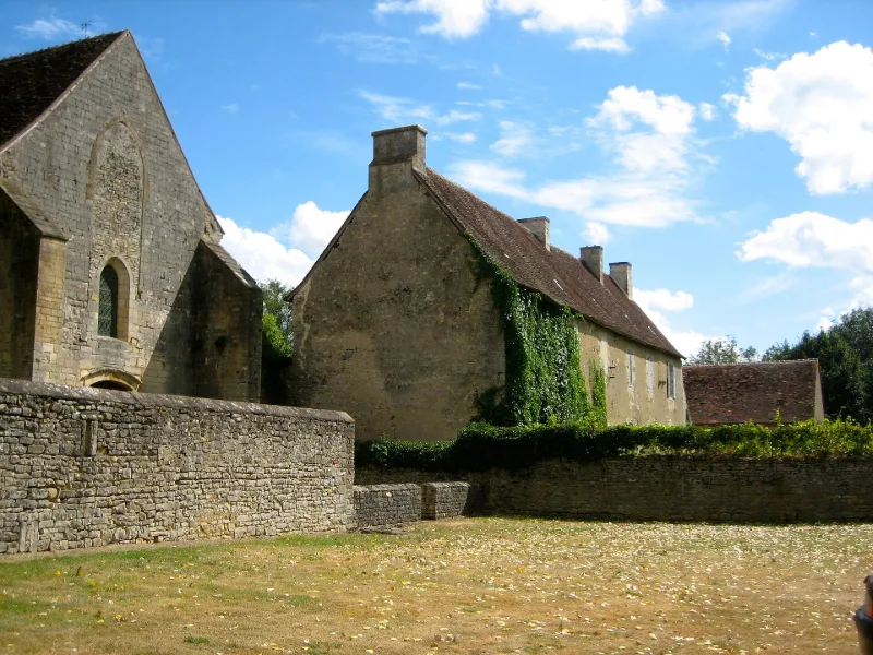
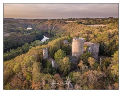
Varennes Abbey
No reviews yet
Have you flown here? Share your experience with other pilots.
+ Write the first reviewHistory
2e moitié 12e siècle ; 13e siècle ; limite 17e siècle 18e siècle La première fondation remonte au milieu du 6e siècle, lorsque des disciples de Saint-Benoît choisirent ce lieu pour s'y installer. La date de la destruction demeure inconnue. En 1148, le prince Ebbe II de Déols fit venir des moines de l'abbaye de Vauluisant pour fonder un monastère affilié à l'ordre de Cîteaux. L'église a été construite dans la deuxième moitié du 12e siècle. Elle présentait une nef flanquée de collatéraux supprimés au 13e siècle. A la même époque, la nef fut raccourcie à l'ouest. Le réfectoire date du 13e siècle. Les bâtiments des convers sont également du 13e siècle ; ils ont été modifiés au 18e siècle. La maison abbatiale a été édifiée à partir de 1698. Au 18e siècle, certains bâtiments ont été remaniés, le transept et le chevet de l'église abattus. A la Révolution, l'abbaye fut transformée en exploitation agricole et le cloître démoli.
Map and restricted areas
Open in the main mapRestricted zones
| Zone | Category | Limits | Conditions |
|---|---|---|---|
| SETBA Secteur COMBRAILLES | Entrainement Militaire | 0 m above ground level → 15241 m above ground level | Pilotage de drones en vue directe : les aéronefs dont la masse est supérieure à 900 grammes sont soumis à notification préalable selon des modalités publiées sur le site www.ecologie.gouv.fr |
| Avord | Zone réglementée | 914 m above sea level → 2297 m above sea level | Vols interdits sauf lorsque the official document of the zone l'autorise explicitement ou avec l'accord du gestionnaire de la zone lorsqu'il est désigné par the official document of the zone |
| Avord | Zone réglementée | 1529 m above sea level → 6259 m above sea level | Vols interdits sauf lorsque the official document of the zone l'autorise explicitement ou avec l'accord du gestionnaire de la zone lorsqu'il est désigné par the official document of the zone |
Nearby aerodromes
Open aerodromes within 25 km of the spot, heliports included, with their distance and direction from the spot. Near an aerodrome, drone flying is prohibited or height-limited: check the UAS zones map.
| Aerodrome | Type | Distance | Elevation |
|---|---|---|---|
| Argenton Sur Creuse Airfield | Aerodrome | 20 km W | 202 m |
Aviation weather (METAR and TAF)
LFLX – Châteauroux-Déols "Marcel Dassault" Airport VFR
METAR
METAR LFLX 171330Z AUTO 22022KT 9999 BKN035 BKN200 OVC220 17/12 Q0997 BECMG 22020G30KT
- Wind
- 220°, 41 km/h
- Visibility
- 10 km or more
- Clouds
- Broken (5-7/8) at 3,500 ft (1070 m) ; Broken (5-7/8) at 20,000 ft (6100 m) ; Overcast (8/8) at 22,000 ft (6710 m)
- Temperature
- 17 °C, dew point 12 °C
- QNH
- 997 hPa
- Flight category
- VFR: ceiling > 3,000 ft and visibility > 5 mi
TAF
TAF LFLX 171100Z 1712/1818 22020G30KT 9999 BKN025 TEMPO 1717/1721 2500 SHRA BKN015CB PROB30 TEMPO 1719/1721 25025G45KT BECMG 1721/1723 24015KT PROB40 TEMPO 1805/1816 24020G30KT PROB30 TEMPO 1805/1810 3000 -TSRA BKN015CB
| Period (local time) | Change | Wind | Visibility | Weather | Clouds |
|---|---|---|---|---|---|
| 17/11 13:00 → 17/11 22:00 | Initial conditions | 220°, 37 km/h, gusts 56 km/h | 10 km or more | Broken (5-7/8) at 2,500 ft (760 m) | |
| 17/11 18:00 → 17/11 22:00 | Temporarily | 2.5 km | Showers of rain | Broken (5-7/8) at 1,500 ft (460 m) (cumulonimbus) | |
| 17/11 20:00 → 17/11 22:00 | Temporarily, probability 30% | 250°, 46 km/h, gusts 83 km/h | |||
| 17/11 22:00 → 18/11 19:00 | Becoming | 240°, 28 km/h | 10 km or more | Broken (5-7/8) at 2,500 ft (760 m) | |
| 18/11 06:00 → 18/11 17:00 | Temporarily, probability 40% | 240°, 37 km/h, gusts 56 km/h | |||
| 18/11 06:00 → 18/11 11:00 | Temporarily, probability 30% | 3.0 km | Thunderstorm rain light | Broken (5-7/8) at 1,500 ft (460 m) (cumulonimbus) |
Weather and Kp index
| Day | Weather | Temp. min. / max. | Wind | Rain | Max Kp |
|---|---|---|---|---|---|
| Tue 17 Nov | Partly cloudy | 12° / 16° | 38 km/h SW | 2.4 mm | 5 |
| Wed 18 Nov | Showers | 10° / 13° | 36 km/h SW | 7.2 mm | 5 |
| Thu 19 Nov | Showers | 9° / 12° | 45 km/h SW | 8.7 mm | 3 |
| Fri 20 Nov | Showers | 8° / 12° | 32 km/h SW | 2.9 mm | 3 |
| Sat 21 Nov | Partly cloudy | 9° / 13° | 22 km/h SW | 0.3 mm | – |
| Sun 22 Nov | Showers | 9° / 11° | 31 km/h SW | 9.5 mm | – |
| Mon 23 Nov | Partly cloudy | 7° / 12° | 24 km/h W | 0.2 mm | – |
Hour by hour: Tuesday 17 November
| Time | Weather | Temp. | Wind | Rain | Clouds | Kp |
|---|---|---|---|---|---|---|
| 15:00 | Partly cloudy | 16° | 32 km/h SW | – | 51 % | 4 |
| 16:00 | Clear sky | 16° | 32 km/h SW | – | 6 % | 4 |
| 17:00 | Fair | 15° | 33 km/h SW | – | 25 % | 4 |
| 18:00 | Showers | 14° | 35 km/h SW | 0.2 mm | 46 % | 4 |
| 19:00 | Heavy rain | 13° | 35 km/h SW | 1.1 mm | 100 % | 5 |
| 20:00 | Light rain | 12° | 37 km/h SW | 0.4 mm | 99 % | 5 |
| 21:00 | Rain | 12° | 38 km/h SW | 0.6 mm | 99 % | 5 |
| 22:00 | Cloudy | 12° | 35 km/h SW | – | 100 % | 5 |
Hour by hour: Wednesday 18 November
| Time | Weather | Temp. | Wind | Rain | Clouds | Kp |
|---|---|---|---|---|---|---|
| 06:00 | Showers | 11° | 26 km/h SW | 0.3 mm | 75 % | 4 |
| 07:00 | Showers | 10° | 26 km/h SW | 0.9 mm | 78 % | 4 |
| 08:00 | Heavy rain | 10° | 28 km/h SW | 1.4 mm | 91 % | 4 |
| 09:00 | Partly cloudy | 10° | 28 km/h SW | – | 82 % | 4 |
| 10:00 | Partly cloudy | 11° | 31 km/h SW | – | 85 % | 4 |
| 11:00 | Fair | 12° | 33 km/h SW | – | 24 % | 4 |
| 12:00 | Showers | 13° | 34 km/h SW | 0.2 mm | 40 % | 4 |
| 13:00 | Showers | 13° | 36 km/h SW | 0.2 mm | 61 % | 3 |
| 14:00 | Showers | 13° | 34 km/h SW | 0.1 mm | 23 % | 3 |
| 15:00 | Fair | 13° | 32 km/h SW | – | 35 % | 3 |
| 16:00 | Partly cloudy | 12° | 30 km/h SW | – | 77 % | 3 |
| 17:00 | Partly cloudy | 12° | 26 km/h SW | – | 48 % | 3 |
| 18:00 | Partly cloudy | 11° | 24 km/h SW | – | 73 % | 3 |
| 19:00 | Cloudy | 11° | 25 km/h SW | – | 95 % | 2 |
| 20:00 | Cloudy | 11° | 27 km/h SW | – | 98 % | 2 |
| 21:00 | Light rain | 11° | 28 km/h SW | 0.2 mm | 100 % | 2 |
| 22:00 | Heavy rain | 12° | 28 km/h SW | 1.3 mm | 100 % | 2 |
Sunrise and sunset
| Day | Dawn | Sunrise | Golden hour | Sunset | Dusk | Day length |
|---|---|---|---|---|---|---|
| Tue 17 Nov | 07:25 | 07:57 | 07:57–08:44 · 16:31–17:17 | 17:17 | 17:50 | 9 h 20 |
| Wed 18 Nov | 07:26 | 07:59 | 07:59–08:46 · 16:29–17:16 | 17:16 | 17:49 | 9 h 17 |
| Thu 19 Nov | 07:27 | 08:00 | 08:00–08:48 · 16:28–17:16 | 17:16 | 17:49 | 9 h 15 |
| Fri 20 Nov | 07:28 | 08:02 | 08:02–08:49 · 16:27–17:15 | 17:15 | 17:48 | 9 h 12 |
| Sat 21 Nov | 07:30 | 08:03 | 08:03–08:51 · 16:26–17:14 | 17:14 | 17:47 | 9 h 10 |
| Sun 22 Nov | 07:31 | 08:04 | 08:04–08:52 · 16:25–17:13 | 17:13 | 17:46 | 9 h 08 |
| Mon 23 Nov | 07:32 | 08:06 | 08:06–08:54 · 16:24–17:12 | 17:12 | 17:46 | 9 h 06 |
Reviews (0)
Log in to review this spot. Log in · Create a free account
No reviews yet. Share yours!