

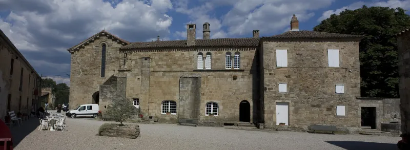
Former Saint-Michel de Grandmont Priory
No reviews yet
Have you flown here? Share your experience with other pilots.
+ Write the first reviewHistory
4e quart 12e siècle ; 13e siècle ; 19e siècle Fondé en 1076 au nord de Limoges par un ermite nommé Etienne, l'ordre de Grandmont se développa rapidement et de nouvelles "celles" furent fondées, notamment en Languedoc. Le monastère du Lodévois était d'une des quatre "celles" du Languedoc, et l'une des premières de l'ordre, tant par l'ancienneté de la fondation que par l'importance de la communauté. L'ordre subsista jusqu'en 1772. Saint-Michel fut fondé en 1128. La chapelle romane alors édifiée fut remplacée à la fin du 12e siècle par l'église actuelle. Au 14e siècle s'amorce le déclin de l'ordre. En 1772, lorsque l'ordre fut supprimé, il ne restait plus que deux moines à Saint-Michel. Le domaine est vendu comme bien national en 1791. L'église est la partie la plus ancienne du prieuré. Construite à la fin du 12e siècle, elle présente une nef unique couverte d'une voûte en berceau légèrement brisé. L'abside semi-circulaire, plus large que la nef, est voûtée en cul de four précédé par une partie en berceau. Seule la porte nord présente un décor d'allure gothique. Au sud, la porte des moines ouvre sur le cloître. Au 14e siècle, construction de la chapelle Saint-Michel. Le clocher, seule entorse à l'austérité de l'ordre, fut édifié assez tardivement (fin 13e-début 14e siècle). De plan carré, le cloître appartient à une seconde tranche de travaux (début 13e siècle). Des galeries sont séparées du préau par un mur bahuit sur lequel s'élèvent des colonnettes jumelées, alternant avec des piles rectangulaires qui reçoivent les retombées des arcs plein-cintre géminés. Les galeries sont couvertes de voûtes sur croisées d'ogives toriques. Les différentes parties des bâtiments monastiques sont encore visibles. A l'est, le "couloir des morts", la salle capitulaire, la salle des moines et un vestibule donnant sur les champs. L'aile sud était autrefois entièrement occupée par le réfectoire et la cuisine. L'aile ouest abritait, à l'origine, les communs et autres locaux utilitaires.
Map and restricted areas
Open in the main mapRestricted zones
| Zone | Category | Limits | Conditions |
|---|---|---|---|
| Zrt Victor | ZRT | From the ground up to about 2,000 m above sea level | SUP AIP 219/26 · Du mardi 20 octobre au jeudi 22 octobre 2026 |
| Tarn | Zone réglementée | 244 m above ground level → 1280 m above sea level | Vols interdits sauf lorsque the official document of the zone l'autorise explicitement ou avec l'accord du gestionnaire de la zone lorsqu'il est désigné par the official document of the zone |
| Istres | Zone réglementée | 1529 m above sea level → 6259 m above sea level | Vols interdits sauf lorsque the official document of the zone l'autorise explicitement ou avec l'accord du gestionnaire de la zone lorsqu'il est désigné par the official document of the zone |
| Istres | Zone réglementée | 5491 m above sea level → 30766 m above sea level | Vols interdits sauf lorsque the official document of the zone l'autorise explicitement ou avec l'accord du gestionnaire de la zone lorsqu'il est désigné par the official document of the zone |
| Istres | Zone réglementée | 5491 m above sea level → 30766 m above sea level | Vols interdits sauf lorsque the official document of the zone l'autorise explicitement ou avec l'accord du gestionnaire de la zone lorsqu'il est désigné par the official document of the zone |
| Istres | Zone réglementée | 5491 m above sea level → 30766 m above sea level | Vols interdits sauf lorsque the official document of the zone l'autorise explicitement ou avec l'accord du gestionnaire de la zone lorsqu'il est désigné par the official document of the zone |
| Istres | Zone réglementée | 5491 m above sea level → 30766 m above sea level | Vols interdits sauf lorsque the official document of the zone l'autorise explicitement ou avec l'accord du gestionnaire de la zone lorsqu'il est désigné par the official document of the zone |
Nearby aerodromes
Open aerodromes within 25 km of the spot, heliports included, with their distance and direction from the spot. Near an aerodrome, drone flying is prohibited or height-limited: check the UAS zones map.
| Aerodrome | Type | Distance | Elevation |
|---|---|---|---|
| Bédarieux La Tour Airfield | Aerodrome | 21 km SW | 377 m |
Aviation weather (METAR and TAF)
LFMU – Béziers-Vias Airport VFR
METAR
METAR LFMU 171330Z AUTO 23009KT CAVOK 16/13 Q1005 TEMPO SCT050TCU
- Wind
- 230°, 17 km/h
- Visibility
- 10 km or more
- Clouds
- –
- Temperature
- 16 °C, dew point 13 °C
- QNH
- 1005 hPa
- Flight category
- VFR: ceiling > 3,000 ft and visibility > 5 mi
TAF
TAF LFMU 170800Z 1709/1809 VRB04KT 9999 BKN013 BECMG 1709/1711 CAVOK TEMPO 1711/1718 -SHRA SCT050TCU TEMPO 1807/1809 -SHRA SCT050TCU
| Period (local time) | Change | Wind | Visibility | Weather | Clouds |
|---|---|---|---|---|---|
| 17/11 10:00 → 18/11 10:00 | Initial conditions | Variable, 7 km/h | 10 km or more | Broken (5-7/8) at 1,300 ft (400 m) | |
| 17/11 10:00 → 18/11 10:00 | Becoming | Variable, 7 km/h | 10 km or more | No significant weather | No significant cloud |
| 17/11 12:00 → 17/11 19:00 | Temporarily | Showers of rain light | Scattered (3-4/8) at 5,000 ft (1520 m) (towering cumulus) | ||
| 18/11 08:00 → 18/11 10:00 | Temporarily | Showers of rain light | Scattered (3-4/8) at 5,000 ft (1520 m) (towering cumulus) |
Weather and Kp index
| Day | Weather | Temp. min. / max. | Wind | Rain | Max Kp |
|---|---|---|---|---|---|
| Tue 17 Nov | Light rain | 11° / 16° | 22 km/h NW | 4.0 mm | 5 |
| Wed 18 Nov | Fair | 10° / 16° | 30 km/h NW | – | 5 |
| Thu 19 Nov | Fair | 9° / 13° | 38 km/h W | 6.5 mm | 3 |
| Fri 20 Nov | Partly cloudy | 9° / 14° | 28 km/h W | – | 3 |
| Sat 21 Nov | Partly cloudy | 10° / 15° | 8 km/h NW | – | – |
| Sun 22 Nov | Fair | 10° / 14° | 26 km/h NW | 0.6 mm | – |
| Mon 23 Nov | Partly cloudy | 8° / 13° | 12 km/h NW | – | – |
Hour by hour: Tuesday 17 November
| Time | Weather | Temp. | Wind | Rain | Clouds | Kp |
|---|---|---|---|---|---|---|
| 15:00 | Light rain | 16° | 21 km/h W | 0.1 mm | 100 % | 4 |
| 16:00 | Light rain | 14° | 16 km/h W | 0.3 mm | 99 % | 4 |
| 17:00 | Heavy rain | 13° | 14 km/h W | 1.5 mm | 91 % | 4 |
| 18:00 | Heavy rain | 12° | 12 km/h SW | 1.2 mm | 96 % | 4 |
| 19:00 | Cloudy | 12° | 10 km/h W | – | 94 % | 5 |
| 20:00 | Light rain | 11° | 12 km/h NW | 0.1 mm | 100 % | 5 |
| 21:00 | Rain | 11° | 14 km/h NW | 0.5 mm | 100 % | 5 |
| 22:00 | Light rain | 11° | 16 km/h NW | 0.3 mm | 100 % | 5 |
Hour by hour: Wednesday 18 November
| Time | Weather | Temp. | Wind | Rain | Clouds | Kp |
|---|---|---|---|---|---|---|
| 06:00 | Cloudy | 12° | 22 km/h W | – | 97 % | 4 |
| 07:00 | Cloudy | 12° | 22 km/h W | – | 88 % | 4 |
| 08:00 | Cloudy | 12° | 24 km/h W | – | 96 % | 4 |
| 09:00 | Partly cloudy | 13° | 26 km/h W | – | 74 % | 4 |
| 10:00 | Partly cloudy | 14° | 28 km/h W | – | 81 % | 4 |
| 11:00 | Cloudy | 15° | 30 km/h NW | – | 90 % | 4 |
| 12:00 | Partly cloudy | 15° | 28 km/h NW | – | 84 % | 4 |
| 13:00 | Fair | 15° | 26 km/h W | – | 22 % | 3 |
| 14:00 | Fair | 16° | 25 km/h W | – | 31 % | 3 |
| 15:00 | Clear sky | 16° | 23 km/h W | – | 5 % | 3 |
| 16:00 | Fair | 15° | 22 km/h W | – | 13 % | 3 |
| 17:00 | Fair | 14° | 16 km/h W | – | 16 % | 3 |
| 18:00 | Partly cloudy | 11° | 13 km/h NW | – | 57 % | 3 |
| 19:00 | Partly cloudy | 10° | 10 km/h NW | – | 73 % | 2 |
| 20:00 | Partly cloudy | 10° | 7 km/h NW | – | 44 % | 2 |
| 21:00 | Partly cloudy | 10° | 5 km/h N | – | 98 % | 2 |
| 22:00 | Partly cloudy | 11° | 5 km/h N | – | 90 % | 2 |
Sunrise and sunset
| Day | Dawn | Sunrise | Golden hour | Sunset | Dusk | Day length |
|---|---|---|---|---|---|---|
| Tue 17 Nov | 07:12 | 07:43 | 07:43–08:27 · 16:36–17:20 | 17:20 | 17:51 | 9 h 36 |
| Wed 18 Nov | 07:14 | 07:45 | 07:45–08:29 · 16:35–17:19 | 17:19 | 17:50 | 9 h 34 |
| Thu 19 Nov | 07:15 | 07:46 | 07:46–08:30 · 16:34–17:18 | 17:18 | 17:49 | 9 h 31 |
| Fri 20 Nov | 07:16 | 07:47 | 07:47–08:31 · 16:33–17:17 | 17:17 | 17:48 | 9 h 29 |
| Sat 21 Nov | 07:17 | 07:48 | 07:48–08:33 · 16:32–17:16 | 17:16 | 17:48 | 9 h 27 |
| Sun 22 Nov | 07:18 | 07:50 | 07:50–08:34 · 16:31–17:16 | 17:16 | 17:47 | 9 h 25 |
| Mon 23 Nov | 07:19 | 07:51 | 07:51–08:36 · 16:30–17:15 | 17:15 | 17:46 | 9 h 24 |
Reviews (0)
Log in to review this spot. Log in · Create a free account
No reviews yet. Share yours!