

Becquet de l'Iton
No reviews yet
Have you flown here? Share your experience with other pilots.
+ Write the first reviewHistory
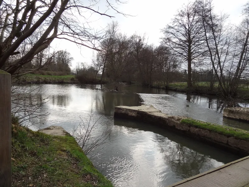
12e siècle ; 1ère moitié 19e siècle Henri Ier Beauclerc a fait creuser le bras de Verneuil pour alimenter en eau les fossés de la ville et construire l'éperon de maçonnerie qui assure la répartition des eaux de l'Iton entre le nouveau canal et le bras de Breteuil. Les maçonneries ont été réparées en 1808. Le bassin de retenue a été agrandi en 1843 et les bassins déversoirs ont été réaménagés. Depuis 1857, sa gestion est assurée dans le cadre d'un règlement de police des eaux par le syndicat des eaux de l'Iton. L'ouvrage s'étend sur 30 kilomètres.
Map and restricted areas
Open in the main mapRestricted zones
| Zone | Category | Limits | Conditions |
|---|---|---|---|
| Zrt l'Aigle - Verneuil d'Avre | ZRT | From the ground up to about 100 m above the ground | SUP AIP 210/25 · Du jeudi 1er janvier 2026 au vendredi 31 décembre 2027 |
| ZRT LE MANS (IHEDN uniquement) | ZRT | From about 3,800 m to about 4,100 m above sea level | SUP AIP 053/26 · Du jeudi 16 avril 2026 au mercredi 12 avril 2028 |
Nearby aerodromes
Open aerodromes within 25 km of the spot, heliports included, with their distance and direction from the spot. Near an aerodrome, drone flying is prohibited or height-limited: check the UAS zones map.
| Aerodrome | Type | Distance | Elevation |
|---|---|---|---|
| Center Parc Heliport | Heliport | 6.4 km S | 196 m |
| Centre Hospitalier de Verneuil Heliport | Heliport | 6.7 km SE | 182 m |
| Aérodrome de L'Aigle-Saint-Michel | Aerodrome | 12 km W | 240 m |
| Centre Hospitalier Heliport | Heliport | 16 km W | 233 m |
Aviation weather (METAR and TAF)
LFOE – Évreux-Fauville (BA 105) Air Base VFR
METAR
METAR LFOE 171330Z AUTO 22016KT 9999 FEW030 BKN200 15/10 Q0990 TEMPO 27030G50KT 2000 SHRA BKN020CB
- Wind
- 220°, 30 km/h
- Visibility
- 10 km or more
- Clouds
- Few (1-2/8) at 3,000 ft (910 m) ; Broken (5-7/8) at 20,000 ft (6100 m)
- Temperature
- 15 °C, dew point 10 °C
- QNH
- 990 hPa
- Flight category
- VFR: ceiling > 3,000 ft and visibility > 5 mi
TAF
TAF LFOE 170800Z 1709/1809 21020G30KT 9999 BKN025 TEMPO 1715/1719 25025G45KT 2000 SHRA BKN025TCU PROB40 TEMPO 1715/1719 27030G50KT -TSRAGS BKN020CB
| Period (local time) | Change | Wind | Visibility | Weather | Clouds |
|---|---|---|---|---|---|
| 17/11 10:00 → 18/11 10:00 | Initial conditions | 210°, 37 km/h, gusts 56 km/h | 10 km or more | Broken (5-7/8) at 2,500 ft (760 m) | |
| 17/11 16:00 → 17/11 20:00 | Temporarily | 250°, 46 km/h, gusts 83 km/h | 2.0 km | Showers of rain | Broken (5-7/8) at 2,500 ft (760 m) (towering cumulus) |
| 17/11 16:00 → 17/11 20:00 | Temporarily, probability 40% | 270°, 56 km/h, gusts 93 km/h | Thunderstorm rain light ; thunderstorm small hail light | Broken (5-7/8) at 2,000 ft (610 m) (cumulonimbus) |
Weather and Kp index
| Day | Weather | Temp. min. / max. | Wind | Rain | Max Kp |
|---|---|---|---|---|---|
| Tue 17 Nov | Cloudy | 10° / 13° | 35 km/h SW | 3.4 mm | 5 |
| Wed 18 Nov | Fair | 9° / 13° | 31 km/h SW | 4.1 mm | 5 |
| Thu 19 Nov | Showers | 8° / 12° | 33 km/h SW | 1.9 mm | 3 |
| Fri 20 Nov | Showers | 8° / 12° | 28 km/h SW | 2.5 mm | 3 |
| Sat 21 Nov | Partly cloudy | 6° / 11° | 24 km/h W | – | – |
| Sun 22 Nov | Light rain | 6° / 10° | 19 km/h SW | 9.4 mm | – |
| Mon 23 Nov | Clear sky | 6° / 10° | 24 km/h W | 0.1 mm | – |
Hour by hour: Tuesday 17 November
| Time | Weather | Temp. | Wind | Rain | Clouds | Kp |
|---|---|---|---|---|---|---|
| 15:00 | Cloudy | 12° | 30 km/h SW | – | 100 % | 4 |
| 16:00 | Light rain | 13° | 33 km/h SW | 0.2 mm | 99 % | 4 |
| 17:00 | Heavy rain | 12° | 35 km/h SW | 1.2 mm | 100 % | 4 |
| 18:00 | Heavy rain | 11° | 33 km/h SW | 1.4 mm | 100 % | 4 |
| 19:00 | Rain | 10° | 30 km/h SW | 0.6 mm | 91 % | 5 |
| 20:00 | Cloudy | 10° | 28 km/h SW | – | 100 % | 5 |
| 21:00 | Partly cloudy | 11° | 28 km/h SW | – | 43 % | 5 |
| 22:00 | Fair | 10° | 28 km/h W | – | 29 % | 5 |
Hour by hour: Wednesday 18 November
| Time | Weather | Temp. | Wind | Rain | Clouds | Kp |
|---|---|---|---|---|---|---|
| 06:00 | Partly cloudy | 10° | 26 km/h SW | – | 61 % | 4 |
| 07:00 | Cloudy | 9° | 26 km/h SW | – | 89 % | 4 |
| 08:00 | Partly cloudy | 10° | 28 km/h SW | – | 50 % | 4 |
| 09:00 | Partly cloudy | 10° | 28 km/h SW | – | 54 % | 4 |
| 10:00 | Fair | 11° | 27 km/h SW | – | 29 % | 4 |
| 11:00 | Fair | 12° | 28 km/h SW | – | 37 % | 4 |
| 12:00 | Showers | 12° | 30 km/h SW | 0.3 mm | 25 % | 4 |
| 13:00 | Fair | 12° | 31 km/h SW | – | 16 % | 3 |
| 14:00 | Clear sky | 13° | 29 km/h SW | – | 12 % | 3 |
| 15:00 | Clear sky | 13° | 27 km/h SW | – | 9 % | 3 |
| 16:00 | Clear sky | 12° | 24 km/h SW | – | 9 % | 3 |
| 17:00 | Partly cloudy | 11° | 23 km/h SW | – | 47 % | 3 |
| 18:00 | Cloudy | 10° | 22 km/h SW | – | 97 % | 3 |
| 19:00 | Rain | 10° | 22 km/h SW | 0.8 mm | 97 % | 2 |
| 20:00 | Rain | 10° | 23 km/h SW | 0.9 mm | 99 % | 2 |
| 21:00 | Rain | 10° | 25 km/h S | 0.9 mm | 99 % | 2 |
| 22:00 | Heavy rain | 10° | 27 km/h S | 1.0 mm | 98 % | 2 |
Sunrise and sunset
| Day | Dawn | Sunrise | Golden hour | Sunset | Dusk | Day length |
|---|---|---|---|---|---|---|
| Tue 17 Nov | 07:34 | 08:09 | 08:09–08:58 · 16:25–17:15 | 17:15 | 17:49 | 9 h 06 |
| Wed 18 Nov | 07:35 | 08:10 | 08:10–09:00 · 16:24–17:14 | 17:14 | 17:48 | 9 h 03 |
| Thu 19 Nov | 07:37 | 08:12 | 08:12–09:02 · 16:22–17:13 | 17:13 | 17:47 | 9 h 00 |
| Fri 20 Nov | 07:38 | 08:13 | 08:13–09:04 · 16:21–17:12 | 17:12 | 17:46 | 8 h 58 |
| Sat 21 Nov | 07:40 | 08:15 | 08:15–09:05 · 16:20–17:11 | 17:11 | 17:46 | 8 h 55 |
| Sun 22 Nov | 07:41 | 08:16 | 08:16–09:07 · 16:19–17:10 | 17:10 | 17:45 | 8 h 53 |
| Mon 23 Nov | 07:42 | 08:18 | 08:18–09:09 · 16:17–17:09 | 17:09 | 17:44 | 8 h 51 |

Reviews (0)
Log in to review this spot. Log in · Create a free account
No reviews yet. Share yours!