

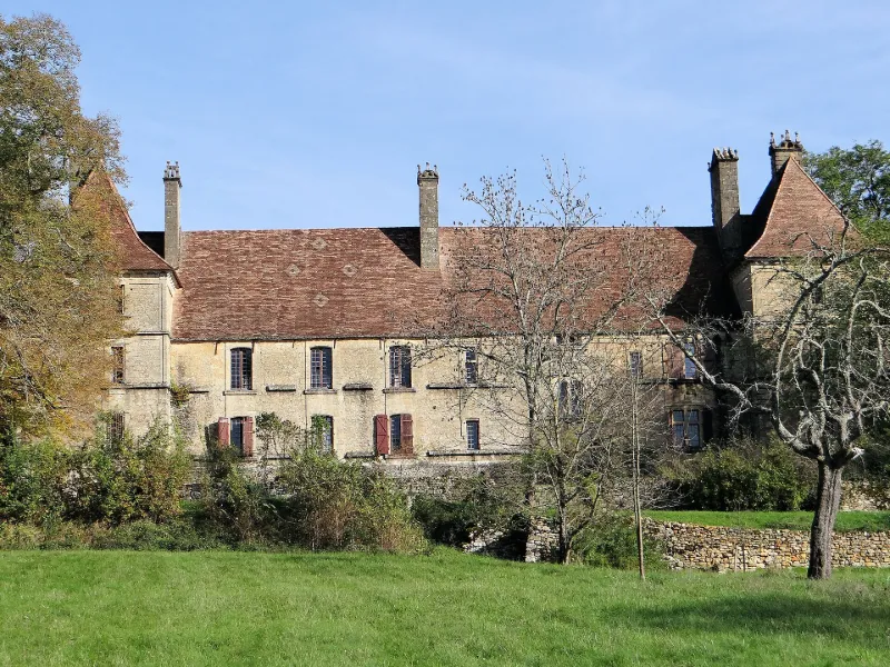
Besse Castle
No reviews yet
Have you flown here? Share your experience with other pilots.
+ Write the first reviewHistory
16e siècle ; 17e siècle Le château actuel fut bâti au 16e siècle puis restauré et agrandi à partir de 1616. La demeure s'organise autour d'une cour carrée. Deux tours rondes limitent le mur est dans lequel s'ouvre le châtelet d'entrée. A l'opposé, est implanté un grand corps de logis ponctué de deux pavillons. L'ensemble est également constitué de bâtiments agricoles et des courtines reliant le logis au côté est. Enfin, deux grandes terrasses avec leur mur se déploient à partir du logis en direction de l'est.
Map and restricted areas
Open in the main mapRestricted zones
| Zone | Category | Limits | Conditions |
|---|---|---|---|
| Sebah Eh 01.067 B | Entrainement Militaire | 0 m above ground level → 9145 m above ground level | Pilotage de drones en vue directe : les aéronefs dont la masse est supérieure à 900 grammes sont soumis à notification préalable selon des modalités publiées sur le site www.ecologie.gouv.fr |
| Zrt Buck Alpha 1 | ZRT | From the ground up to about 1,500 m above sea level | SUP AIP 166/26 · Du lundi 17 août 2026 au mercredi 14 avril 2027 |
| Zrt Buck Alpha 2 | ZRT | From the ground up to about 1,500 m above sea level | SUP AIP 166/26 · Du lundi 17 août 2026 au mercredi 14 avril 2027 |
| Zena Perigord High | ZRT | FL 395 / UNL | SUP AIP 062/26 · Du jeudi 23 avril 2026 au jeudi 25 mars 2027 |
| Zrt Buck Bravo 1 | ZRT | 5000 ft AMSL / FL 085 | SUP AIP 166/26 · Du lundi 17 août 2026 au mercredi 14 avril 2027 |
| Zrt Buck Bravo 2 | ZRT | FL 085 / FL 115 | SUP AIP 166/26 · Du lundi 17 août 2026 au mercredi 14 avril 2027 |
Nearby aerodromes
Open aerodromes within 25 km of the spot, heliports included, with their distance and direction from the spot. Near an aerodrome, drone flying is prohibited or height-limited: check the UAS zones map.
| Aerodrome | Type | Distance | Elevation |
|---|---|---|---|
| Aérodrome de Belvès Saint-Pardoux | Aerodrome | 18 km NW | 241 m |
| Sarlat Domme Airfield | Aerodrome | 18 km NE | 298 m |
| Fumel Montayral Airport | Aerodrome | 24 km S | 211 m |
Aviation weather (METAR and TAF)
No METAR station within 50 km.
Weather and Kp index
| Day | Weather | Temp. min. / max. | Wind | Rain | Max Kp |
|---|---|---|---|---|---|
| Tue 17 Nov | Rain | 12° / 14° | 21 km/h SW | 6.3 mm | 5 |
| Wed 18 Nov | Partly cloudy | 11° / 15° | 23 km/h W | 7.9 mm | 5 |
| Thu 19 Nov | Showers | 9° / 12° | 30 km/h W | 17 mm | 3 |
| Fri 20 Nov | Rain | 8° / 12° | 22 km/h SW | 11 mm | 3 |
| Sat 21 Nov | Cloudy | 8° / 14° | 13 km/h SE | 1.8 mm | – |
| Sun 22 Nov | Showers | 9° / 12° | 20 km/h W | 6.9 mm | – |
| Mon 23 Nov | Cloudy | 7° / 13° | 14 km/h SW | 0.2 mm | – |
Hour by hour: Tuesday 17 November
| Time | Weather | Temp. | Wind | Rain | Clouds | Kp |
|---|---|---|---|---|---|---|
| 15:00 | Rain | 14° | 17 km/h SW | 0.9 mm | 100 % | 4 |
| 16:00 | Heavy rain | 13° | 16 km/h SW | 2.0 mm | 100 % | 4 |
| 17:00 | Heavy rain | 12° | 14 km/h SW | 2.2 mm | 100 % | 4 |
| 18:00 | Light rain | 12° | 14 km/h SW | 0.4 mm | 100 % | 4 |
| 19:00 | Cloudy | 12° | 17 km/h SW | – | 98 % | 5 |
| 20:00 | Cloudy | 12° | 18 km/h SW | – | 100 % | 5 |
| 21:00 | Light rain | 12° | 21 km/h SW | 0.1 mm | 98 % | 5 |
| 22:00 | Rain | 12° | 19 km/h SW | 0.7 mm | 100 % | 5 |
Hour by hour: Wednesday 18 November
| Time | Weather | Temp. | Wind | Rain | Clouds | Kp |
|---|---|---|---|---|---|---|
| 06:00 | Fair | 12° | 19 km/h W | – | 34 % | 4 |
| 07:00 | Fair | 12° | 19 km/h W | – | 23 % | 4 |
| 08:00 | Fair | 12° | 21 km/h W | – | 27 % | 4 |
| 09:00 | Fair | 12° | 16 km/h W | – | 31 % | 4 |
| 10:00 | Fair | 13° | 21 km/h W | – | 16 % | 4 |
| 11:00 | Showers | 14° | 21 km/h W | 0.5 mm | 44 % | 4 |
| 12:00 | Showers | 13° | 23 km/h W | 0.6 mm | 81 % | 4 |
| 13:00 | Partly cloudy | 13° | 19 km/h SW | – | 56 % | 3 |
| 14:00 | Cloudy | 14° | 22 km/h W | – | 99 % | 3 |
| 15:00 | Fair | 15° | 19 km/h W | – | 26 % | 3 |
| 16:00 | Showers | 14° | 17 km/h W | 0.1 mm | 51 % | 3 |
| 17:00 | Fair | 13° | 13 km/h SW | – | 25 % | 3 |
| 18:00 | Fair | 12° | 11 km/h SW | – | 17 % | 3 |
| 19:00 | Cloudy | 11° | 11 km/h S | – | 98 % | 2 |
| 20:00 | Cloudy | 12° | 13 km/h S | – | 100 % | 2 |
| 21:00 | Cloudy | 12° | 17 km/h SE | – | 100 % | 2 |
| 22:00 | Heavy rain | 12° | 19 km/h SE | 1.2 mm | 100 % | 2 |
Sunrise and sunset
| Day | Dawn | Sunrise | Golden hour | Sunset | Dusk | Day length |
|---|---|---|---|---|---|---|
| Tue 17 Nov | 07:23 | 07:55 | 07:55–08:40 · 16:41–17:26 | 17:26 | 17:58 | 9 h 31 |
| Wed 18 Nov | 07:25 | 07:56 | 07:56–08:41 · 16:40–17:25 | 17:25 | 17:57 | 9 h 28 |
| Thu 19 Nov | 07:26 | 07:58 | 07:58–08:43 · 16:39–17:24 | 17:24 | 17:56 | 9 h 26 |
| Fri 20 Nov | 07:27 | 07:59 | 07:59–08:44 · 16:38–17:23 | 17:23 | 17:55 | 9 h 24 |
| Sat 21 Nov | 07:28 | 08:00 | 08:00–08:46 · 16:37–17:23 | 17:23 | 17:55 | 9 h 22 |
| Sun 22 Nov | 07:29 | 08:01 | 08:01–08:47 · 16:36–17:22 | 17:22 | 17:54 | 9 h 20 |
| Mon 23 Nov | 07:31 | 08:03 | 08:03–08:48 · 16:35–17:21 | 17:21 | 17:53 | 9 h 18 |

Reviews (0)
Log in to review this spot. Log in · Create a free account
No reviews yet. Share yours!