

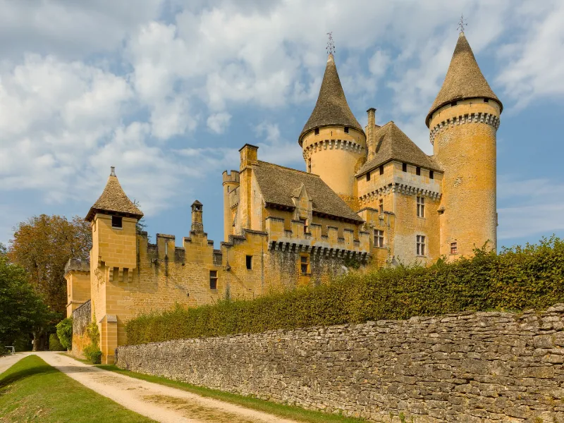
Puymartin Castle
No reviews yet
Have you flown here? Share your experience with other pilots.
+ Write the first reviewHistory
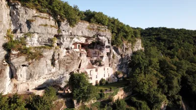
15e siècle ; 16e siècle ; 17e siècle Le château fut une importante forteresse entourée de courtines et d'échauguettes. En 1357, les Anglais s'en emparèrent. Durant les guerres de Religion, il servit de repaire au capitaine Puymartin, chef catholique qui reprit Sarlat aux Calvinistes en 1534. L'accès à la cour intérieure se fait par un châtelet. Les deux corps de logis des 15e et 16e siècles sont soudés par deux tours à mâchicoulis accostées d'une poivrière contenant un escalier à vis de Saint-Gilles. La partie ancienne est terminée par un chemin de ronde avec trous à couleuvrines. Une grande salle conserve un belle cheminée et des tapisseries. Poutres peintes au pochoir. Le cabinet lambrissé qui fait suite est peint en trompe l'oeil de sujets païens et chrétiens. Ces peintures à la colle, traitées comme des fresques, doivent dater du début du 17e siècle.
Map and restricted areas
Open in the main mapRestricted zones
| Zone | Category | Limits | Conditions |
|---|---|---|---|
| Sebah Eh 01.067 B | Entrainement Militaire | 0 m above ground level → 9145 m above ground level | Pilotage de drones en vue directe : les aéronefs dont la masse est supérieure à 900 grammes sont soumis à notification préalable selon des modalités publiées sur le site www.ecologie.gouv.fr |
| Zena Perigord Low | ZRT | FL 165 / FL 195 | SUP AIP 062/26 · Du jeudi 23 avril 2026 au jeudi 25 mars 2027 |
| Zena Perigord Medium | ZRT | FL 195 / FL 245 | SUP AIP 062/26 · Du jeudi 23 avril 2026 au jeudi 25 mars 2027 |
| Zena Perigord High | ZRT | FL 395 / UNL | SUP AIP 062/26 · Du jeudi 23 avril 2026 au jeudi 25 mars 2027 |
Nearby aerodromes
Open aerodromes within 25 km of the spot, heliports included, with their distance and direction from the spot. Near an aerodrome, drone flying is prohibited or height-limited: check the UAS zones map.
| Aerodrome | Type | Distance | Elevation |
|---|---|---|---|
| La Canéda Centre Hospitalier Heliport | Heliport | 6.5 km E | 200 m |
| Sarlat Domme Airfield | Aerodrome | 15 km SE | 298 m |
| Aérodrome de Belvès Saint-Pardoux | Aerodrome | 20 km SW | 241 m |
| Aérodrome de Peyrillac | Aerodrome | 22 km E | 274 m |
| Condat sur Vézère | Aerodrome | 22 km N | 152 m |
Aviation weather (METAR and TAF)
LFSL – Brive-Souillac MVFR
METAR
METAR LFSL 171400Z AUTO 20005KT 160V270 9999 BKN017/// BKN025/// OVC100/// ///TCU 15/14 Q1002 TEMPO 4000 -SHRA
- Wind
- 200°, 9 km/h
- Visibility
- 10 km or more
- Clouds
- Broken (5-7/8) at 1,700 ft (520 m) ; Broken (5-7/8) at 2,500 ft (760 m) ; Overcast (8/8) at 10,000 ft (3050 m)
- Temperature
- 15 °C, dew point 14 °C
- QNH
- 1002 hPa
- Flight category
- MVFR: ceiling 1,000–3,000 ft or visibility 3–5 mi
TAF
TAF LFSL 171400Z 1715/1724 21008KT 9999 BKN020 TEMPO 1715/1724 24015G25KT 3000 -SHRA BKN025TCU
| Period (local time) | Change | Wind | Visibility | Weather | Clouds |
|---|---|---|---|---|---|
| 17/11 16:00 → 18/11 01:00 | Initial conditions | 210°, 15 km/h | 10 km or more | Broken (5-7/8) at 2,000 ft (610 m) | |
| 17/11 16:00 → 18/11 01:00 | Temporarily | 240°, 28 km/h, gusts 46 km/h | 3.0 km | Showers of rain light | Broken (5-7/8) at 2,500 ft (760 m) (towering cumulus) |
Weather and Kp index
Sunrise and sunset
| Day | Dawn | Sunrise | Golden hour | Sunset | Dusk | Day length |
|---|---|---|---|---|---|---|
| Tue 17 Nov | 07:24 | 07:56 | 07:56–08:40 · 16:40–17:25 | 17:25 | 17:57 | 9 h 29 |
| Wed 18 Nov | 07:25 | 07:57 | 07:57–08:42 · 16:39–17:24 | 17:24 | 17:56 | 9 h 27 |
| Thu 19 Nov | 07:26 | 07:58 | 07:58–08:43 · 16:38–17:23 | 17:23 | 17:55 | 9 h 25 |
| Fri 20 Nov | 07:27 | 07:59 | 07:59–08:45 · 16:37–17:23 | 17:23 | 17:55 | 9 h 23 |
| Sat 21 Nov | 07:29 | 08:01 | 08:01–08:46 · 16:36–17:22 | 17:22 | 17:54 | 9 h 21 |
| Sun 22 Nov | 07:30 | 08:02 | 08:02–08:48 · 16:35–17:21 | 17:21 | 17:53 | 9 h 18 |
| Mon 23 Nov | 07:31 | 08:03 | 08:03–08:49 · 16:34–17:20 | 17:20 | 17:53 | 9 h 16 |
Reviews (0)
Log in to review this spot. Log in · Create a free account
No reviews yet. Share yours!