

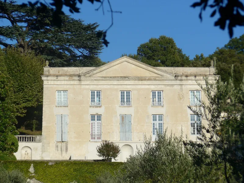
Serre-de-Parc Estate
No reviews yet
Have you flown here? Share your experience with other pilots.
+ Write the first reviewHistory
2e moitié 18e siècle Domaine aménagé entre 1770 et 1780 à partir d'une ancienne maison forte. Corps de logis construit dans le style néo-classique. Domaine en partie détruit après la Révolution : nombreux remaniements au 19e siècle. Grande galerie décorée de gypseries évoquant le jardinage, la chasse, les arts et les sciences. Disposition du parc prévue dès le projet de 1770 : parc composé de terrasses, d'un jardin à la française et de vergers.
Map and restricted areas
Open in the main mapRestricted zones
| Zone | Category | Limits | Conditions |
|---|---|---|---|
| MONTELIMAR ANCONE Aérodrome (26) | Activité de loisirs | 0 m above ground level → 152 m above ground level | Flights reserved for members and guests of the club, under the terms set by the model-aircraft field manager |
| Zrt Privas High | ZRT | FL 175 / FL 185 | SUP AIP 055/26 · Du jeudi 16 avril 2026 au mercredi 12 avril 2028 |
| Zrt Rone 1 | ZRT | 1000 ft ASFC / 3500 ft AMSL | SUP AIP 207/26 · Du lundi 28 septembre au vendredi 16 octobre 2026 |
Nearby aerodromes
Open aerodromes within 25 km of the spot, heliports included, with their distance and direction from the spot. Near an aerodrome, drone flying is prohibited or height-limited: check the UAS zones map.
| Aerodrome | Type | Distance | Elevation |
|---|---|---|---|
| Aérodrome de Montélimar - Ancône | Aerodrome | 1.2 km SW | 73 m |
| Aérodrome de Pierrelatte | Aerodrome | 21 km S | 60 m |
Aviation weather (METAR and TAF)
LFLU – Valence-Chabeuil Airport VFR
METAR
METAR LFLU 171400Z AUTO 20010KT 9999 SCT042 BKN190 BKN230 13/11 Q1003
- Wind
- 200°, 19 km/h
- Visibility
- 10 km or more
- Clouds
- Scattered (3-4/8) at 4,200 ft (1280 m) ; Broken (5-7/8) at 19,000 ft (5790 m) ; Broken (5-7/8) at 23,000 ft (7010 m)
- Temperature
- 13 °C, dew point 11 °C
- QNH
- 1003 hPa
- Flight category
- VFR: ceiling > 3,000 ft and visibility > 5 mi
TAF
Weather and Kp index
Sunrise and sunset
| Day | Dawn | Sunrise | Golden hour | Sunset | Dusk | Day length |
|---|---|---|---|---|---|---|
| Tue 17 Nov | 07:09 | 07:40 | 07:40–08:25 · 16:27–17:12 | 17:12 | 17:43 | 9 h 31 |
| Wed 18 Nov | 07:10 | 07:41 | 07:41–08:26 · 16:26–17:11 | 17:11 | 17:42 | 9 h 29 |
| Thu 19 Nov | 07:11 | 07:43 | 07:43–08:28 · 16:25–17:10 | 17:10 | 17:42 | 9 h 27 |
| Fri 20 Nov | 07:12 | 07:44 | 07:44–08:29 · 16:24–17:09 | 17:09 | 17:41 | 9 h 25 |
| Sat 21 Nov | 07:13 | 07:45 | 07:45–08:31 · 16:23–17:08 | 17:08 | 17:40 | 9 h 22 |
| Sun 22 Nov | 07:15 | 07:47 | 07:47–08:32 · 16:22–17:08 | 17:08 | 17:40 | 9 h 20 |
| Mon 23 Nov | 07:16 | 07:48 | 07:48–08:34 · 16:21–17:07 | 17:07 | 17:39 | 9 h 18 |

Reviews (0)
Log in to review this spot. Log in · Create a free account
No reviews yet. Share yours!